
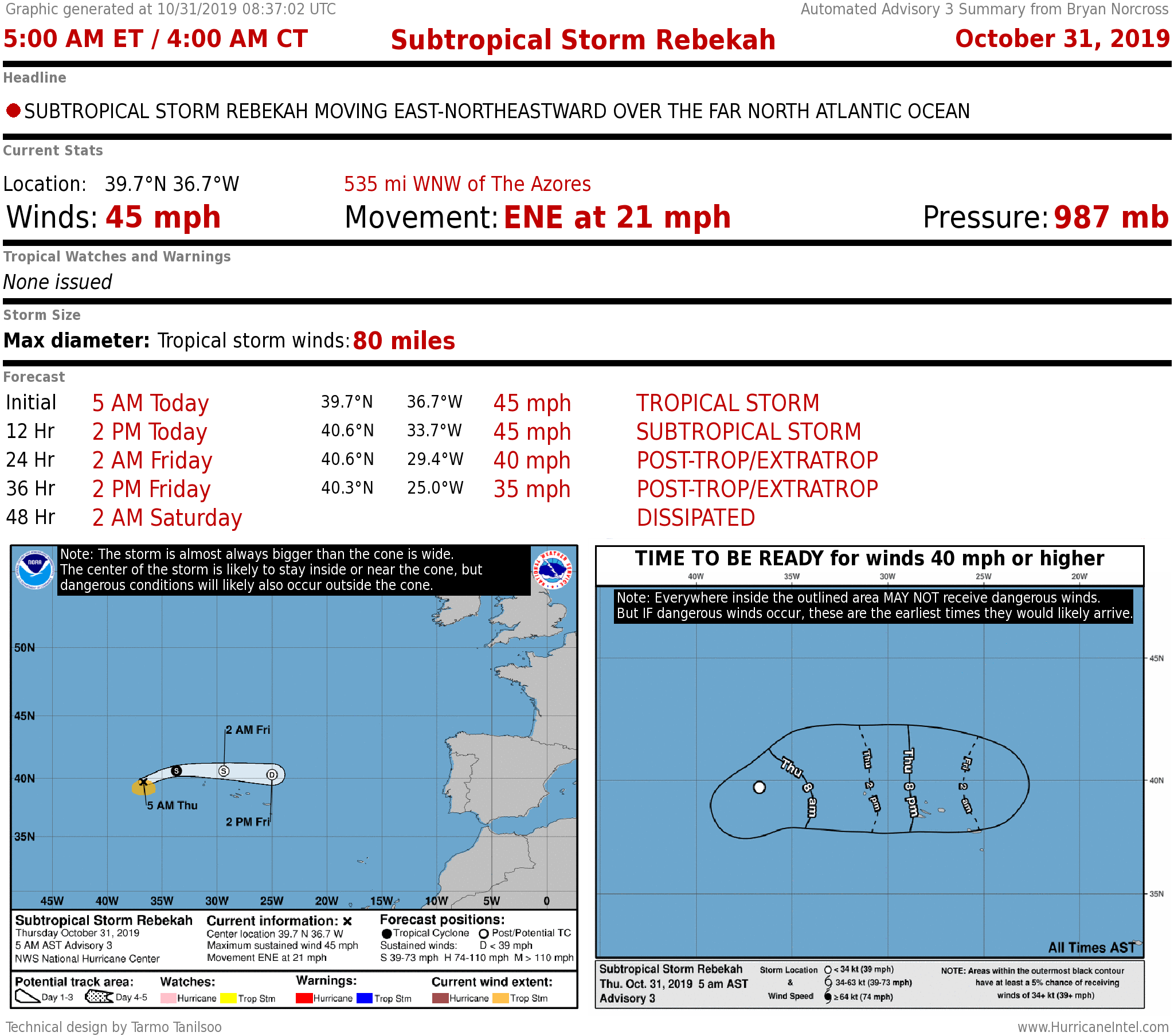
Subtropical Storm Rebekah in the northeast Atlantic doesn't have long to live. Close to home, high pressure continues to dominate the weather over South Florida. No front to fully sweep away the moisture is forecast for at least another week.
Tiny Subtropical Storm Rebekah is forecast to turn back into a typical wintertime storm in the northeast Atlantic later today or tomorrow. The system is forecast to head north of the Azores Islands off of Portugal, but as a weaker system. The islands will likely feel some fringe effects.
Recommended Videos
Yesterday, enough thunderstorms wrapped around the center of circulation of the giant low-pressure system in the middle of the Atlantic to identify the center as a separate weather system and give it a name. This is not uncommon. Those huge low-pressure systems are deep in the atmosphere, so the upper-level winds are light near the center.
When a system like that is stationary or moving slowly, sometimes the atmospheric environment is sufficient for a separately identifiable system to develop from the spinning air at the ocean surface. Temperatures are often too cold to maintain the quasi-tropical nature of the systems however, especially once the whole low-pressure area starts moving north.
A strong cold front has brought winter to east Texas. The front is moving toward Florida. The high-pressure system that has been dominating South Florida weather this fall will be pushed east a bit, but should hang tough enough to keep the front from pushing all the way through the state. The current consensus of the computer forecast models is that the front will stall near Lake Okeechobee, but be close enough to increase the chance of rain and create a modest change in the weather through the weekend.
Extreme South Florida is expected to stay on the warm and humid side of the front, though the breeze will increase off the ocean late in the weekend or early next week making it more comfortable. Increased cloudiness and rain will make it a bit cooler as well.
That front is expected to recede back north and die out early in the week, and the long-range computer models don't show any significant front pushing through Florida for next seven days, at least.
CLICK HERE to have the Bryan Norcross Talks Tropics newsletter delivered to your inbox.
Elsewhere in the tropics, there is a Tropical Disturbance well south of the Cabo Verde Islands, which are off of Africa. There is a slight chance it could attain a circulation, but the odds are it will just move through the southern Caribbean Islands as a moisture surge next week.