
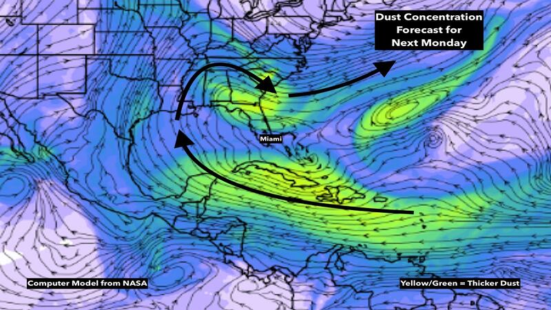
The stunningly dense blanket of dust from the Sahara Desert continues to cover the Caribbean. The edge of the plume has moved over South Florida, but it’s hardly detectable. NASA’s specialized computer forecast model, which we use to forecast where the dust will move, shows that Saharan air will continue to overspread the tropics through next week.
The good news is, the trajectory of the forecast wind flow over the Caribbean and Gulf is forecast to keep the core of the plume south of Florida, and then swing it north over Texas and then back east over the southeastern U.S.
Most of Florida is currently forecast to be in the middle of this horseshoe-shape dust path. If the computers are right, we will only see minor effects.
Scientific analyses from various locations in the Caribbean indicate that this plume is as dense as any ever measured, and in some cases thicker. The obvious question is, why is this happening?
The short answer is, these things happen on occasion. But there are factors to consider. The dust is injected into the atmosphere by thunderstorm complexes that form over Africa. These are the same disturbances that become the seeds for hurricanes later in the season as they move off the African continent and over the tropical Atlantic.
This time of year, these disturbances move west only as moisture surges, due to generally unfavorable upper-level winds, and for now, a dry and dusty atmosphere. We have noticed in the computer forecast models, however, that some of these disturbance – so called tropical waves – have been quite strong in spite of the Saharan Dust.

One of the factors cited by NOAA forecasters leading to a prediction of an active hurricane season was the forecast of more rainfall, i.e. more and/or stronger disturbances, over Africa south of the Sahara Desert. Whether the excess dust and the strong disturbances in the computer forecast models fit with the pattern that was forecast for later in the summer remains to be seen. But, at the least, it gives us pause.
Elsewhere in the tropics:
Well north of the dust belt, Tropical Storm Dolly evolved out of a daughter system spawned by the giant upper-level low-pressure system that affected the entire East Coast last week. The system that became Dolly passed over the Gulf Stream well off the coast of New England, and that was enough to gain it some tropical characteristics. It is dying quickly today in the cold North Atlantic.
In the modern era – since 1991 – the average date for the fourth named storm has been August 16th, so we are obviously spectacularly ahead of schedule – in fact this is the earliest “D” storm in the record book. But, once again, this stormed was generated by processes unrelated to how strong hurricanes form in the heart of hurricane season, so we shouldn’t draw any conclusions from its formation.
For now, and likely through next week, the Saharan dust should keep the tropics calm, as it usually is this time of year.
Copyright 2020 by WPLG Local10.com - All rights reserved.
