
Artificial Intelligence continues to chisel away at the hurricane forecast problem, with Google’s DeepMind flagship AI hurricane model once again leading the pack in 2026.
In verification data shared by former National Hurricane Center Branch Chief James Franklin, so far in 2026 Google DeepMind is besting all other publicly available hurricane forecast guidance for track prediction in the Atlantic, eastern Pacific, and central Pacific basins.

Through the first week of September DeepMind is also notably outpacing track predictions from the world-class forecasters at the National Hurricane Center by as much as 30% for a five-day forecast. This is the second year in a row that DeepMind has topped NHC’s human-refined forecasts at most lead times. The AI model has been especially prescient at longer time horizons – that is at 4 and 5 days out – compared to NHC and the former gold-standard Hurricane Forecast Improvement Project Corrected Consensus Approach or HCCA aid.
Meanwhile, DeepMind continues to put up an impressive performance in tropical cyclone intensity prediction this year, especially against the computationally demanding, high-fidelity hurricane models such as the HAFS suite which have become a mainstay of hurricane intensity forecasting in recent years.
While DeepMind is keeping pace with NHC’s official intensity forecast, it hasn’t shown as dramatic an outperformance as on the track forecast side. It’s been HCCA – an adaptive aid that leverages the best-performing models but corrects for their biases on the fly in real time – that’s having a banner year so far in the intensity forecast department.

And what about the famed Euro?
Franklin was quick to note that neither the famed physics-based European model nor its AI counterpart is in his season-to-date verification numbers. While the newer AI-based European model showed tremendous promise for track intensity last hurricane season – similar to DeepMind and better than the conventional Euro model – as we wrote back in June, it was absolutely atrocious in forecasting intensity, showing essentially negative skill (that is, worse than using a simple climatology).
Developers at the European Centre are aware of the AI’s model’s proclivity to vastly underestimate storm intensity and in August introduced a lightweight post-processing fix which in back tests for 2025 reduced the AI model’s tropical cyclone intensity error by a factor of three, which could make it a true DeepMind competitor if the correction carries forward operationally for future years.
For now, the correction is based only on the single-run (so-called deterministic) AI model and not the more useful AI ensembles that professional hurricane forecasters lean on. The European Centre is working to stress test and evaluate the correction on its AI ensembles with the goal of improving the Euro AI intensity forecasts. But for now – including this hurricane season – we should remain wary of underdone hurricane intensity forecasts from the Euro AI ensembles.
Jump around, jump around
One area where human forecasters routinely add value to the forecast is in forecast consistency. Whereas computer models can shift wildly from run-to-run – windshield-wipering back and forth every 6 or 12 hours – forecasters prefer gradual adjustments over time, something called continuity in forecast-speak.
Critical decisions with costly ramifications hinge on every forecast, so forecasters want to make sure when models shift, it’s an actual trend and not a short-term jump, before making big adjustments to the forecast. A steady, reliable forecast is easier to make decisions from than one that bounces around every 6 hours.
Similar to being a passenger on an airplane, you wouldn’t want your pilot to suddenly jerk the airplane up or down based on an unforeseen bout of turbulence. This could be dangerous for unprepared passengers on board. However, if the turbulence doesn’t relent or becomes significant, you’d expect the captain to gradually climb or descend to a more comfortable altitude, even if it meant a little more time in bumpy skies beforehand to confirm.
NHC knows it will sacrifice some forecast accuracy for consistency but also knows consistency matters when making challenging decisions like large scale evacuations ahead of a hurricane. NHC’s goal is to be the most accurate and most consistent among the forecasts.
Lowell showcasing NHC’s consistency
Hurricane Lowell that sideswiped Kauaʻi and Niʻihau in Hawaii and lashed parts of the state earlier this week is a good recent example of how even the best models can jump around. Its track shifted significantly east in the 72 hours leading up to its closest approach to Hawaii, putting the state’s westernmost islands suddenly in play for a direct hit from its dangerous core.
Though Google DeepMind had substantially lower track errors for Lowell than any nearest competitor, including NHC’s official forecast, it did initially jump around erratically – far more than NHC’s gradual shift eastward – as it finally settled on an eastward trend over the weekend.


“Ideally you want to get the correct track as soon as possible so that warnings can go up with ample lead time,” wrote James Franklin in a post on BlueSky Tuesday which accompanied his analyses. “But it looks to me like OFCL [the official NHC forecast] homed in…on the track [of Hurricane Lowell] faster than GDMI [Google DeepMind]…and with better timing consistency.”
The models are considered “raw” output for a reason and it’s left to the discretion of the human forecaster to not only interpret the output but massage the model forecast in a way that’s most useful for those whose lives and livelihood are at risk.
Tropical tumbleweeds at the peak
Today (September 10th) is the official peak of the hurricane season, the day on which you’re most likely to find a named storm across the Atlantic basin. Not only do we see no named storms looking across the Gulf, Caribbean, or wider Atlantic today, we see no tropical depressions or any tropical contenders on the near horizon.

A ribbon of record-setting wind shear for the time of year should shut down activity over the next week at least across the deep tropics.
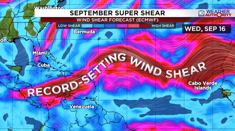
The only suspect area any of our models show looking out the next few weeks is in the open subtropical Atlantic in a week or so. For now, odds are low but we’ll watch the trends to see if a real signal emerges in the days ahead. Regardless it’s not anything for us stateside to worry about.

Copyright 2026 by WPLG Local10.com - All rights reserved.
