The large tropical disturbance we’ve been following is still trying to get organized. Until and if it does, it will not be able to significantly strengthen. And the Caribbean islands with the tallest mountains appear to be in the path between the system and Florida.
If it can form a well-developed circulation, it will be named Tropical Storm Isaias.
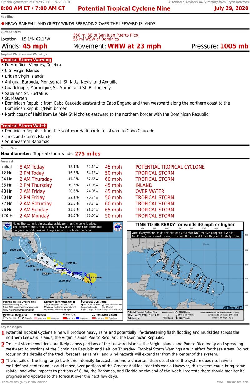
The broad approximate center of the disturbance is near the eastern Caribbean islands on a path in the general direction of Puerto Rico and the Dominican Republic.
Gusty winds in tropical squalls with very heavy rain are impacting the islands and will continue spreading to the west.
The National Hurricane Center’s cone aims across the Dominican Republic and toward Florida, but the future path and strength of the storm are fraught with uncertainty.
It’s still a ragged, ill-defined system. The rule is, if you don’t know where the center is today, and we don’t, you can’t make an accurate forecast of its future.
The storm is trying to form out of an extremely large circulation, which is slowing its development process. In addition, a dense plume of Saharan Dust is moving west with the storm. The dust will have a negative effect if it can work its way into the circulation.
Directly ahead in or near the storm’s path are the very tall mountains of the Dominican Republic. Whether the storm runs over those mountains or skirts around them will affect what happens downstream. Those mountains are tall enough to disrupt or destroy a tropical system’s circulation. This system’s large size might lessen the mountains’ impact, but it will still have a weakening effect.
In general, the weaker the storm is due to dust or its interaction with the mountains, the more likely it is to stay to the left side of the cone. If it can hold off the dust and/or skirt between the mountains and Puerto Rico, it is more likely to favor the right side of the cone and turn to the north.
In addition, when the system gets into the Bahamas or near Florida, the upper-level winds are forecast to become somewhat hostile, which will weaken the storm if the prediction is correct.
The computer forecast models take all these factors into account in trying to predict where the storm will be four or five days from now, and how strong it will be at that time. The track and the intensity are interrelated, of course, so a very slight difference in either one can significantly change the outcome.
FLORIDA IMPACTS
On the current schedule, Tropical Storm Isaias or its remnants would affect South Florida beginning Saturday and perhaps last into Sunday. If the storm is relatively weak, it will likely slow down and take a while to pass.
We should have a better idea tomorrow how strong it will be in our vicinity since we should know how much the tall mountains damage the circulation.
The odds at this point favor a weakening storm over or near Florida over the weekend bringing squalls with tropical downpours and gusty winds. But we don’t know how strong it will get at its peak. If it gets fairly strong out over the ocean, it could still be stronger when it is near Florida, even if the trend is toward weakening.
For now, be ready to take action tomorrow and Friday in case it suddenly looks like Tropical Storm Isaias will be stronger than is now expected.
Elsewhere, there are no signs that anything else will develop in the tropics for the rest of this week.
Copyright 2020 by WPLG Local10.com - All rights reserved.
