
Author’s note: The taxpayer-funded tools from NOAA I consulted to provide the forecast information and analyses in today’s newsletter include satellite data from the Cooperative Institute for Research in the Atmosphere (CIRA) and wind analyses from the University of Wisconsin’s Cooperative Institute for Meteorological Satellite Studies (CIMSS). Both CIRA and CIMSS area slated for elimination in NOAA’s 2026 proposed budget.
A disorganized area of low pressure that moved across north Florida from the Atlantic yesterday is migrating westward through the northern Gulf today.
As we’ve discussed in previous newsletters, development is unlikely as strong wind shear and land entanglements keep the system in check over the next day or two. The National Hurricane Center is maintaining very low development odds, mainly for a brief period tomorrow as it nears the upper Texas coast and harsh upper-level winds begin to subside.
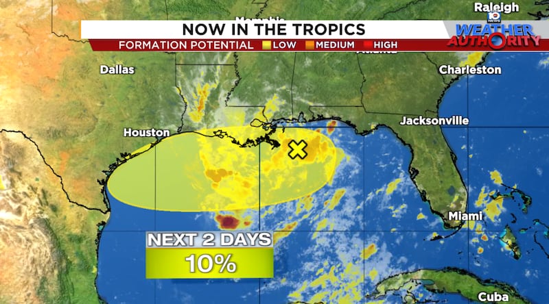
The paper-thin development window will quickly shut as the disturbance moves inland early Saturday.
The upshot regardless will be periods of heavy rain along and south of the I-10 corridor from the central and northeastern Gulf Coast today to parts of the Texas coastal plain tomorrow and Saturday.
In general, rainfall rates and totals over land look manageable and the National Weather Service is keeping the risk of flash flooding at marginal (level 1 of 4) for the next few days, meaning mainly isolated, localized flooding.

We’ll keep an eye on the movement of the system, as any northward deviation of the broad low-pressure center could shift the heavier totals from over water to over land, but for now widespread flash flooding isn’t expected.
Elsewhere across the Atlantic
We continue to see more robust tropical waves moving through the deep Atlantic. Though the American GFS shows some interest in the wave that rolled off Africa earlier this week, forecast models are overall tepid on development odds for now.
Nevertheless, we’ll be watching these disturbances a little more closely, especially once we turn the calendar to August next week.
CLICK HERE to download the Local 10 Weather Authority’s 2025 hurricane survival guide.
Copyright 2025 by WPLG Local10.com - All rights reserved.
