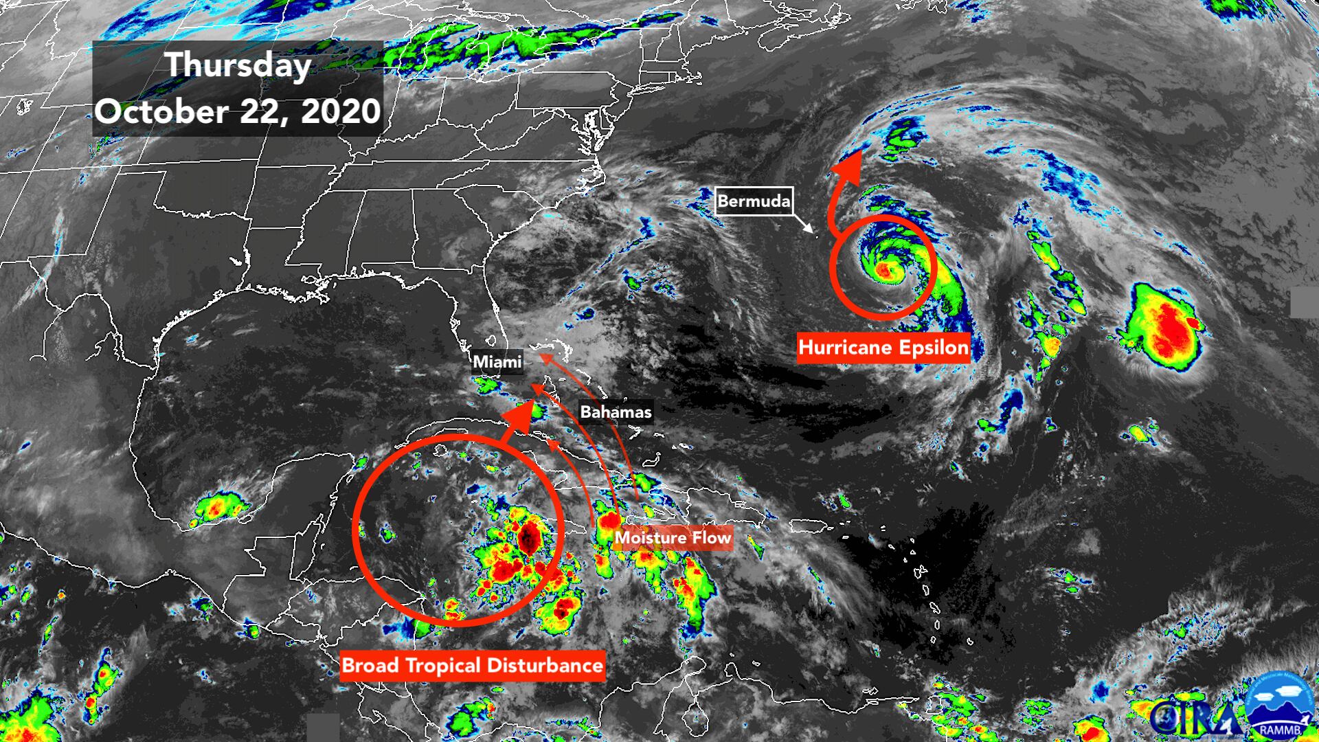
Hurricane Epsilon rapidly intensified into a Category 3 hurricane Wednesday, which was significantly stronger than forecast. While the weather pattern is not typical for a strong hurricane, the contrast between the warm ocean and the cold air aloft seems to have provided enough energy for it to spin up. Now the weakening process is underway as it heads to the north into cooler water.
Later today, the center of the hurricane is forecast to pass well to the east of Bermuda, but still track close enough to put winds of 40 mph or higher over the island. A Tropical Storm Warning is in effect. The strongest winds in the circulation should stay well offshore, however.
The future track of Epsilon takes it into the North Atlantic where it will eventually be absorbed by a northern storm.
Epsilon’s move to the north will have the effect of neutralizing the western nose of the strong high-pressure system that has been contributing to the strong winds over Florida. That wind flow is one of the factors that has been supporting the persistent rainy weather. As a result of the high being out of the picture, the amount of rain coverage is forecast to decrease today with even less coverage tomorrow, but some downpours are still expected in South Florida.
Another factor in the rainy pattern has been a broad low-pressure system over the western Caribbean. That system is tapping rich tropical moisture and has been feeding it north. This system is forecast to be suppressed a bit to the south through tomorrow, but over the weekend indications are it will move back north.
A subtle dip in the jet stream across the southern U.S. is forecast to come along and scoop that system and its moisture north. Whether the moisture surge affects the Bahamas, the southern Florida peninsula or both is an open question. The systems involved are not very strong, and therefore less prone to being forecast well.
Right now, we just need to be ready for a return of extra-moist tropical air over the weekend. The chances of another round of wet weather are highest in the Bahamas, the Keys, and Miami-Dade.
The pure odds are somewhat lower in Broward and points north, but the line between fairly dry and quite wet will likely be sharp, and it can’t be pinned down yet.
After the system passes through the Bahamas and past South Florida, there is a slight chance it could organize into a tropical depression, although the odds are low. The only threat from this system appears to be, once again, the potential for heavy rain.
With the ground fully saturated in South Florida, local flooding would be a threat. It will be something to watch for if and where the rain materializes.
Once the system passes on Monday, much drier air is forecast to push into South Florida next week.
Whether this is the beginning of the fall season is still an open question. As we get later in the year, the jet stream dips farther and farther south, on average, and that eventually pushes dry northern air into South Florida and the tropics making tropical development much less likely.
No strong cold fronts are evident, but a change in the right direction looks likely early next week after the disturbance passes.

Copyright 2020 by WPLG Local10.com - All rights reserved.
