
PEMBROKE PARK, Fla. — This year’s first tropical system may form before the Atlantic hurricane season even starts. The National Hurricane Center is eyeing an area around the northern Bahamas for potential subtropical development this weekend.
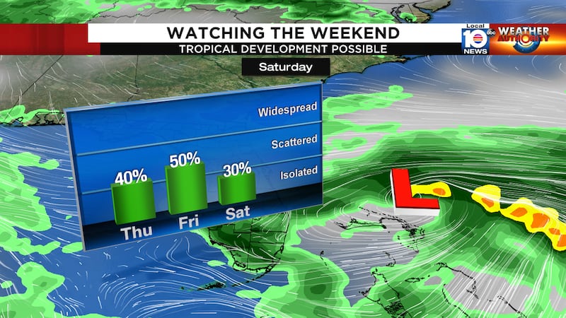
The system has a 50% chance of development this weekend.
An area of low pressure is expected to form along a stalled out frontal boundary draped over southern Florida this weekend. Models continue to place this developing low around the Bahamas on Saturday.

Due to the fact that this low will be interacting with a frontal boundary, it will not possess fully tropical characteristics. Therefore, if it were to strengthen, it would be classified as a subtropical system. This means it is the characteristics of a tropical cyclone and a cold front. Think of it as a hybrid of the two.
This system will have a very short window to develop this weekend into early next week. Sea surface temperatures are barely warm enough to support tropical development.
On top of that, we expect this system to interact with a trough to the north next week, and therefore pull it to the northeast into even cooler waters.
According to our Weather Authority Hurricane Specialist, Bryan Norcross: “The bottom line is, if the system ends up meeting the NHC criteria to be classified subtropical, it does not affect the weather the system will cause. It will essentially be an ocean storm, as are common in the winter. If the models are right, however, it will incorporate tropical air as it forms off the Bahamas. At this point, we’re talking about a system that is only in the computer models. It doesn’t exist yet. The details of what’s going to happen may well change as we get closer to the weekend.”
Regardless of formation, the potential impacts for South Florida remain the same. Tropical moisture will increase across South Florida late week into the first half of the weekend. This will increase rain chances across the area. If this system does develop, it would make conditions along our offshore waters on the choppy side, making boating more difficult.
Stick with your Weather Authority all week for continued updates on this potential formation and increased rain chances coming our way. And click here to get the latest forecasts and weather news delivered straight to your email inbox.
The Atlantic hurricane season officially starts on June 1.
ALSO SEE
New Hurricane Season forecast predicts busier than normal season
Florida makes plans for dealing with coronavirus during hurricane season
Copyright 2020 by WPLG Local10.com - All rights reserved.
