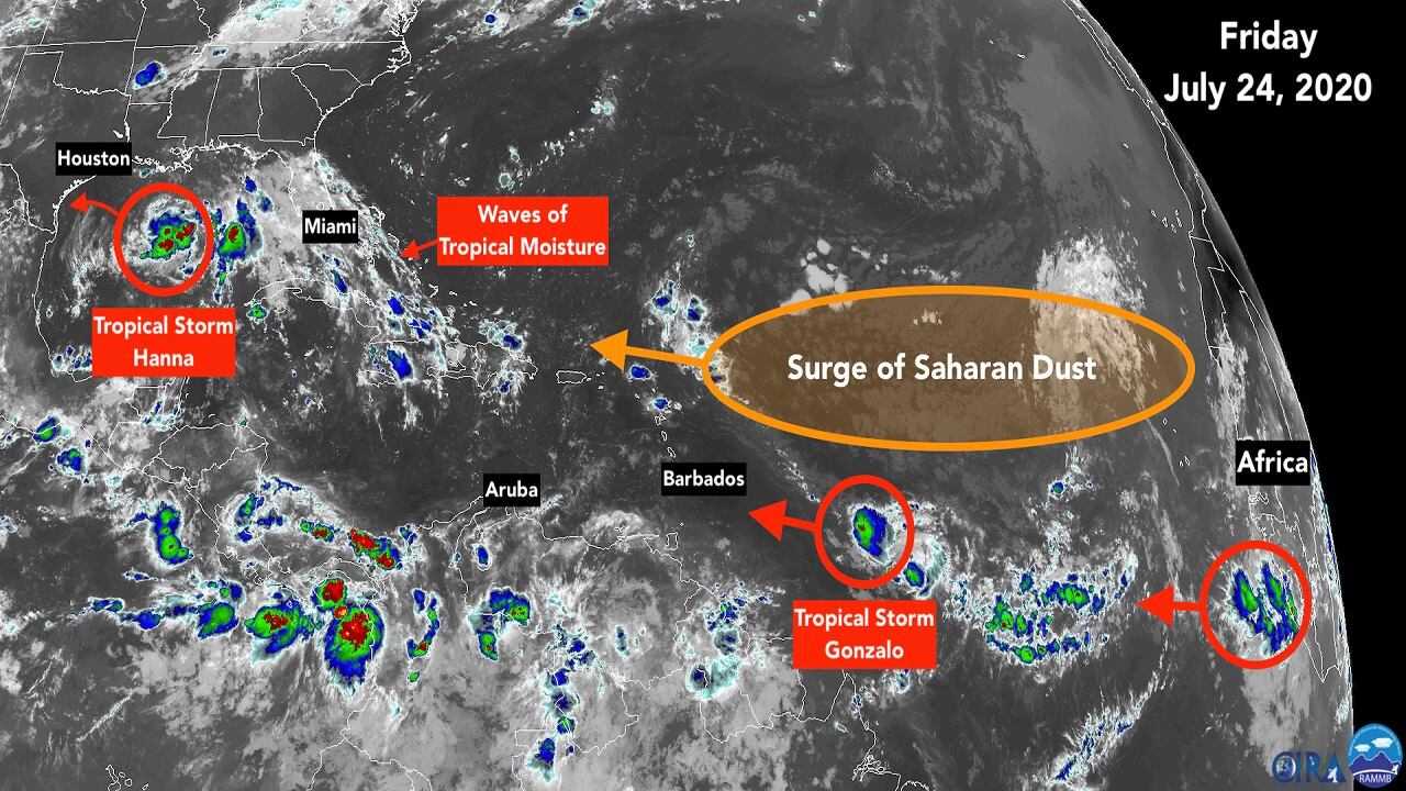
Tropical Storm Hanna is continuing to get organized as it heads toward the Texas coast. Far out in the Atlantic, Tropical Storm Gonzalo could still become a hurricane as it tracks toward the eastern Caribbean islands. And in the Pacific, fierce Hurricane Douglas is on course for the Hawaiian Islands. All three of these storms will impact land over the weekend.
Tropical Storm Hanna formed in the Gulf of Mexico out of the Tropical Disturbance that brought days of clouds and rain to South Florida. The moisture associated with the consolidating storm has finally moved off the Florida peninsula, but the persistent strong flow of air off the ocean will continue to bring in waves of tropical moisture mixed with gaps of drier air. Finally, some Saharan Dust is forecast to be caught in the flow next week bringing in a drier spell.

Hanna is the first “H” storm in the record book to occur in July – with a week still left in the month! In terms of the total energy created by the tropical systems so far this year, however, we are way behind peak years of the past. The systems have generally been fairly weak, and a few were very short-lived.
The center of Hanna is forecast to cross the Texas coast tomorrow. It still has time to further organize over the warm Gulf water with upper-level winds conducive for strengthening. There is a long history of storms strengthening very quickly just offshore of the Texas coastline, so residents there should stay aware of changing forecasts.
Winds gusting to near hurricane force will likely affect the middle and southern Texas coast, and flooding rain is forecast for Louisiana, Texas and Northern Mexico, with the most in South Texas. Just as the system affected South Florida long after it passed through, the moist flow feeding into Hanna will produce very heavy rainfall well away from where the center comes ashore.
Out in the Atlantic, about 600 miles east of the southern Caribbean islands, micro Tropical Storm Gonzalo is the little storm that could. Yesterday it took a big gulp of dry, dusty air, which gummed up its works. But its tiny core has now moistened up, and it’s gathering strength over the warm ocean and with generally favorable upper winds.

The National Hurricane Center is forecasting it to be at or near hurricane strength when it approaches the southern Caribbean islands tomorrow.
About the time Gonzalo gets to the islands, the atmosphere is forecast to become much more hostile. Dry Saharan air should get sucked into the system causing fairly rapid weakening. It’s impossible to know whether that will happen just before or just after it crosses the islands, so everybody on the warned islands needs to be ready for a strong storm.
Gonzalo is a tiny storm, so it won’t affect much area. The worst of it could even slide between islands. But nobody under a hurricane warning can count on a miss.
Once Gonzalo gets into the Caribbean, it is forecast to fairly quickly weaken and dissipate. The remnants are expected to continue off to the west well south of Florida.
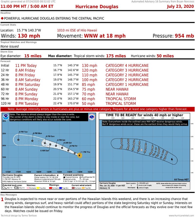
In the Pacific, powerful Hurricane Douglas is forecast to slowly weaken as it approaches the Big Island of Hawaii Saturday night or early Sunday and Maui later in the day. It reached Category 4 strength but will now encounter colder ocean water east of the islands.
A tropical system interacting with the volcanic mountains on the Hawaiian Islands can cause big problems. Winds are stronger at higher elevations, and the mountains can enhance the already torrential rain causing potential mudslides.
Back in the Atlantic, a tropical disturbance has moved off Africa and will follow Gonzalo across the deep tropics. It is far enough south to avoid the Saharan Dust plume, at least for now. Some of the computer forecast models predict that it will find a moist enough corridor to continue west toward the Caribbean islands, so we’ll have to watch it over the next several days.
Except for Hanna, no tropical systems are expected to affect the Atlantic or Gulf coastlines into the middle of next week, at least.
Copyright 2020 by WPLG Local10.com - All rights reserved.
