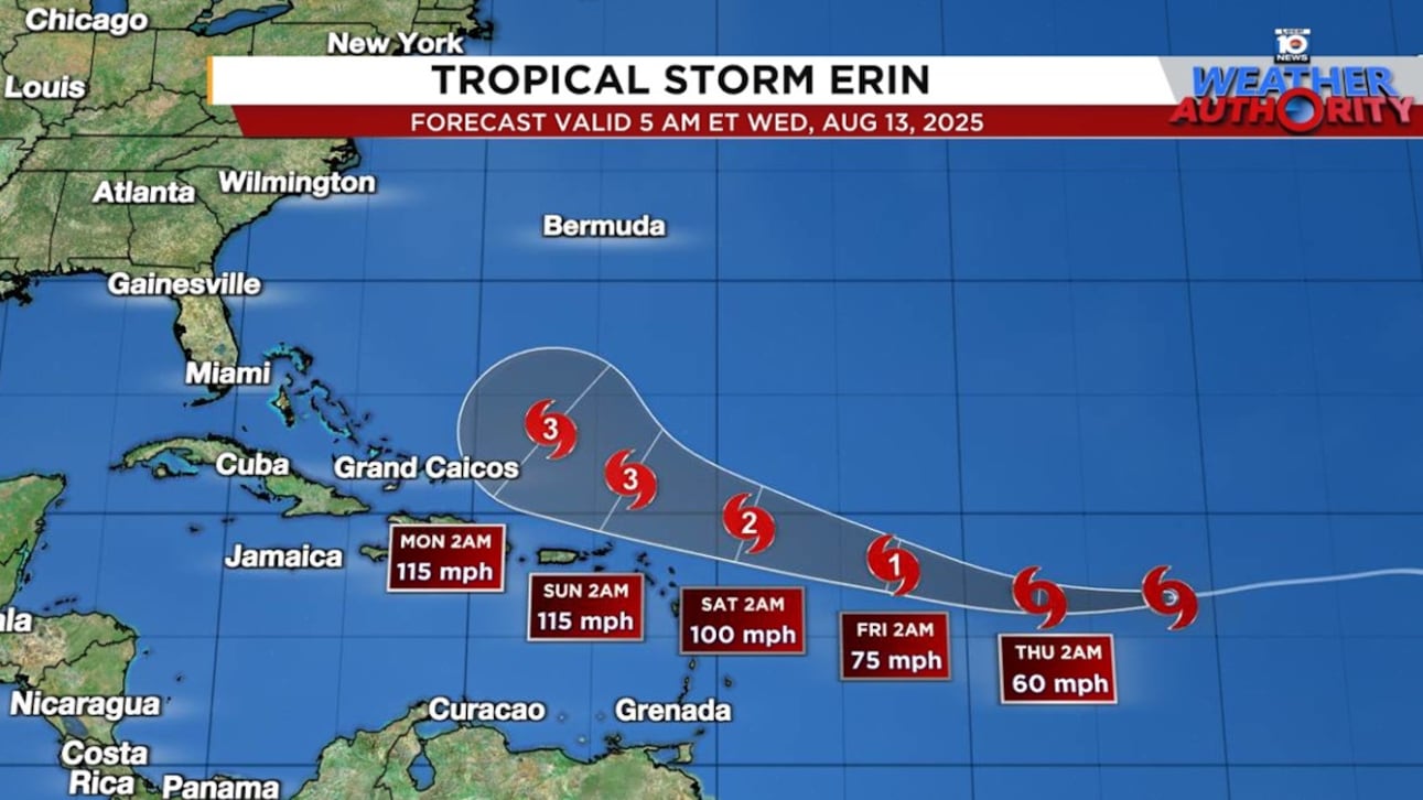
After waffling over Erin’s future path in recent days, forecast models seem to have settled on a course that will take the center of the future hurricane just north of the Leeward Islands, U.S. Virgin Islands, and Puerto Rico this weekend, with nearly all models now turning it safely east of the broader U.S. next week.
On the forecast track, however, Erin with move precariously close to the islands of the northeastern Caribbean as a strengthening hurricane this weekend, so interests in these areas will want to continue to closely monitor the situation for any shifts in track.
At a minimum, periphery effects like squally trailing rainbands with gusty winds are likely beginning on Saturday and extending through the weekend, which could bring the threat of flooding.

Erin is expected to be a strong Category 3 hurricane as it rounds the western edge of the subtropical high pressure dome and turns north into the Atlantic well east of the mainland U.S., but dangerous rip currents will likely be a problem along eastern U.S. beaches next week due to Erin’s long swell.
It’s too soon to say what impact Erin might have on Bermuda, but those with interests in the British Overseas Territory will want to follow the forecasts closely, especially for the middle part of next week.
Erin sailing along
Though Erin is beginning to show signs of strengthening, it hasn’t appreciably changed since Tuesday. Part of the struggle so far, as we discussed in Tuesday’s newsletter, has been it’s position over relatively cool waters – waters still in the 78 to 79 degree Fahrenheit (~26°C) range, marginal temperatures for tropical development.

Erin will cross into much warmer waters beginning later today and on Thursday, waters that will promote more robust thunderstorm activity and help it organize and develop more quickly.
The other development deterrent so far has been Erin’s fast forward motion. The storm has been sailing along at speeds as high as 23 mph, an incredibly fast clip for developing storms in this part of the tropics (top 3%).

Erin is the 12th fastest-moving named storm ever observed across the Atlantic Main Development Region in the satellite record (since 1966), according to an analysis on Tuesday shared by former NHC branch chief James Franklin.

The fast forward motion works against Erin’s ability to organize and reduces the strength of the circulation, particularly on the southern half of the storm where the motion counteracts the circulation.
This is evident in satellite wind estimates that show no tropical storm winds south of Erin’s center due to its fast forward speed.

Erin is expected to slow down, especially as it rounds the edge of high pressure steering this weekend, which will allow it to organize and strengthen more quickly.
Intensity guidance generally plateaus at Category 2 or 3 late this upcoming weekend as wind shear begins to tick up.

An open lane of escape
As we discussed in Tuesday’s newsletter, a lane will open up in high-pressure steering to Erin’s north this weekend, carved out by a dip in the jet stream.
This will give Erin an exit ramp into the north Atlantic before it reaches the Bahamas or the mainland U.S. Both the American GFS and European model camps are in good agreement now, with this turn happening safely east of us stateside.


The forecasts do, however, suggest a close call for Bermuda in the Tuesday/Wednesday time frame next week, so residents here will want to check back frequently on the forecasts this weekend.
No other significant threats for now
As we’ve discussed this week, the Atlantic will stay active into the latter part of August.
The only other near-term system we’re following is a tropical wave over the western Caribbean that’s forecast to sneak into the extreme southern Gulf and Bay of Campeche on Friday.
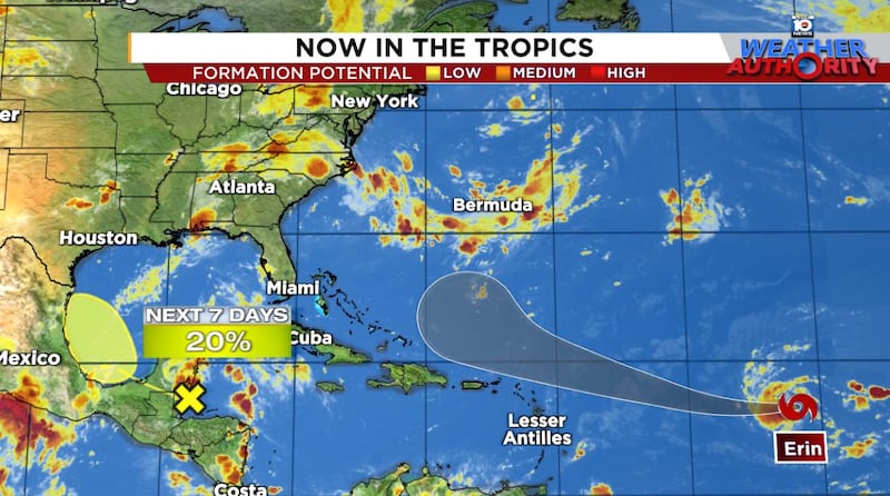
Models indicate a low chance of slow development tomorrow and Friday but this will most likely spread tropical air and rains to northeastern Mexico and South Texas for Saturday.
CLICK HERE to download the Local 10 Weather Authority’s 2025 hurricane survival guide.
Copyright 2025 by WPLG Local10.com - All rights reserved.
