
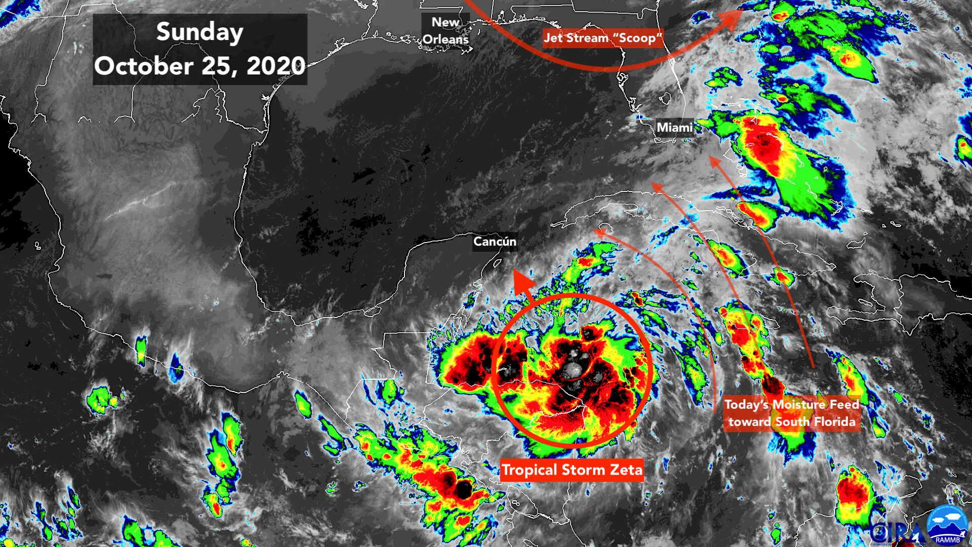
Tropical Storm Zeta formed in the western Caribbean overnight out of Tropical Depression Twenty-Eight, which formed more or less on schedule yesterday afternoon. Zeta’s eventual track will take it into the Gulf of Mexico and over the northern Gulf coast about midweek.
This is the 27th named storm this hurricane season. That doesn’t tie the 2005 record, quite. In the monster year that included Katrina, Rita, and Wilma, a 28th storm in the far eastern Atlantic was identified during the post-season review. That system was estimated to have had peak winds of 50 mph. So 2005 still holds the record with 28 named storms, even though the east-Atlantic storm wasn’t named in real time, and goes down in the record book as simply “Unnamed Subtropical Storm.”
Zeta is the letter that follows Epsilon in the Greek alphabet. In 2005, we made it to Zeta as well. If heaven forbid we get another named storm this year, its name will be Eta (pronounced ATE-uh).
Zeta is meandering around in the western Caribbean, just north of Honduras and east of Belize on the Yucatán Peninsula. It’s under a supportive atmospheric pattern, and the Caribbean water is plenty warm. The system is not organized internally, however. Though that should gradually happen given the conducive environment.
Late today and tomorrow, the storm is forecast to begin a move to the north. On the current schedule, it will take almost 2 days before Zeta reaches the vicinity of Cancún on the northern Yucatán and enters the southern Gulf of Mexico. That’s plenty of time for the storm to organize and intensify. The official National Hurricane Center forecast calls for Zeta to be at or near hurricane strength at that time.
While Zeta is creeping northwest in the Caribbean today, a dip in the jet stream moving across the northern Gulf will scoop moisture north over the southern Florida peninsula.
Periods of heavy tropical rain are likely in South Florida today. The ground is still saturated from the multi-day rain last week, so the National Weather Service has a Flood Watch in effect for the entire area.
The rain won’t last as long on the southeast coast this time, however. A pattern shift beginning tomorrow will affect Zeta’s track and the South Florida weather.
Following the jet-stream scoop, a bubble of high pressure will move over the peninsula, which will dramatically improve the weather in South Florida. The flow around the high will push the moisture to the southwest so that by late on Monday, noticeably drier air will cover the state. The Lower Keys will be the last to clear because they will be closest to Zeta, with the drier air more likely arriving on Tuesday.
The second big effect of the high-pressure bubble will be to create an arcing path north over the Gulf of Mexico for Zeta, so the storm will finally pick up some forward speed.
The official forecast calls for Zeta to be a hurricane over the Gulf before the environment becomes somewhat more hostile as it closes in on the northern coast. We have to remember, of course, that intensity forecasts for newly developed systems three days in advance are prone to large errors. But in any case, once again, residents along the northern Gulf coast are going to have to stay informed and prepare to take action for yet another potential storm.
For the 7th time this hurricane season, New Orleans is in the cone.
This protective high-pressure bubble over Florida has been the story of 2020. That’s been the most important factor in deflecting the storms into the Gulf.

As to where the storm will make landfall, it’s too early to say. After the high-pressure system starts to arc it north, a strong disturbance moving across the southern U.S. will take over and push it over the northern Gulf coast. So it’s a bank shot that gets it to wherever it makes landfall.
Just like in billiards, a slight change in the angles involved will make a big difference in where it ends up. We have to let the storm and the steering currents develop before we can have any confidence in the forecast. Everybody from Louisiana to the Florida Panhandle needs to stay aware.
On the current schedule, Zeta would reach the northern Gulf coast on Wednesday.
After Zeta is gone, that same strong disturbance will push a cold front toward South Florida late in the week or over the weekend. It might bring some fall weather, but the long-range computer forecast models are not yet in firm agreement. The current long-range forecasts for the following front forecast it to be very strong, however, and come blasting through early next week. Fresh fall air may arrive around Election Day, we’ll see.
Copyright 2020 by WPLG Local10.com - All rights reserved.
