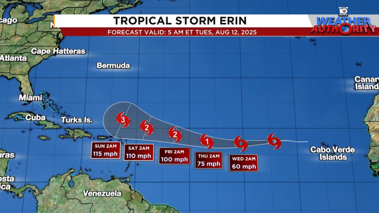
Erin, the fifth named storm of the hurricane season, formed on Monday over the eastern Atlantic and is poised to strengthen into the first hurricane of the season by Thursday as it tracks westward.
Though forecast models largely keep the center of Erin north of the northernmost islands of the eastern Caribbean this weekend – including Puerto Rico and the U.S. Virgin Islands – models shifted south late Monday, making a northward pass a little less comfortable. Interests in the islands should continue to monitor the forecast trends in days ahead, as Erin is expected to grow into a strong hurricane by this weekend.
It’s too soon to make a call on whether Erin could pose any direct threat to the U.S., but for now the consensus still suggests a turn north into a weakness in high-pressure steering between the U.S. and Bermuda early next week.

It’s worth reiterating that forecasts 5 to 10 days out are subject to large errors, so we’ll need to hang tight before confidently giving the U.S. the all-clear. Nevertheless, with Erin forecast to grow into a powerful hurricane, expect dangerous waves and rip currents to be a threat up and down the Eastern Seaboard next week.
Forecast models waffle
As is typical with developing systems like Erin, forecast models jumped noticeably south and west late Monday, moving the potential track of Erin closer to land areas down the line.

By early Tuesday, however, some models like the American GFS had shifted back north and east for next week.

The dramatic windshield-wipering often accompanying forecasts more than five days out is the reason we shouldn’t get too worked up over any single model forecast for next week with Erin. The trend since yesterday has generally been south and west, but for now the consensus keeps Erin’s track north of the islands and east of the U.S.
This of course is subject to change, but even with a shift west in most models yesterday, a mainland U.S. threat remains a far west scenario for now.

As we mentioned in yesterday’s newsletter, interests in Bermuda will especially want to follow Erin’s forecasts closely.
Crossing the threshold
Erin has largely been on the struggle bus since yesterday, with very little in the way of strong, organized thunderstorms. In fact, this morning, it’s mostly a naked swirl of clouds at its fledgling center.
Erin’s struggles have mainly to do with its thermodynamic environment, namely the cooler sea surface temperatures way out over the far eastern Atlantic. Water temperatures are around 78 to 79 degrees (~26°C) Fahrenheit nearby Erin, the floor for tropical development. This is creating a more stable environment and dampening robust thunderstorm growth.
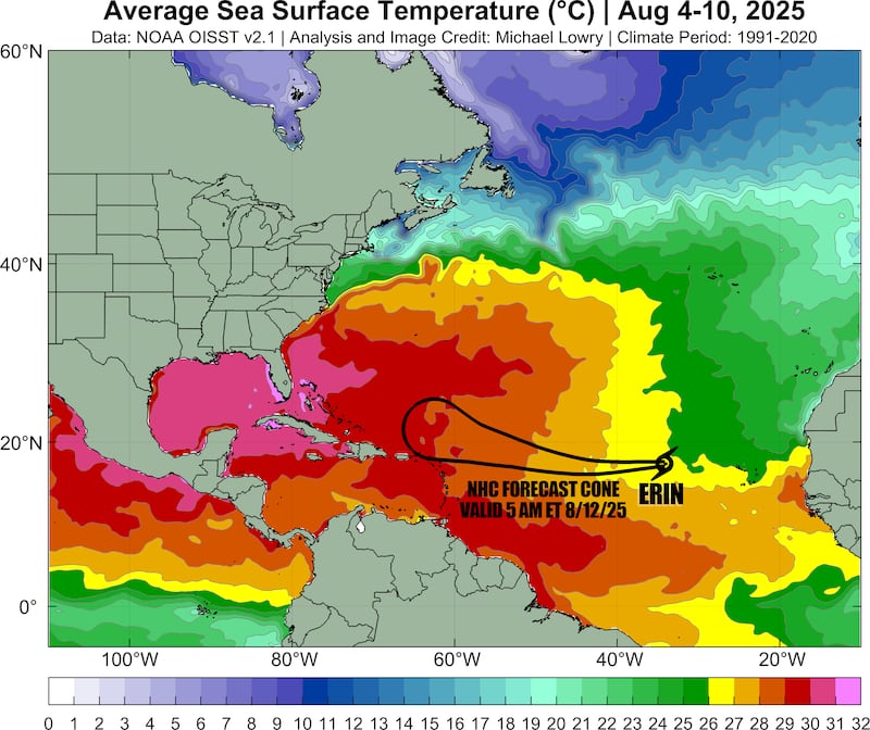
That’s expected to pass come tomorrow as Erin crosses the threshold to much warmer waters that will continue to warm along its path, destabilizing the environment and promoting persistent thunderstorm growth. This should allow Erin to commence strengthening later today and on Wednesday.
Models show a ripe environment by the time it reaches the western Atlantic this weekend, with Erin possibly reaching major (Category 3) hurricane strength by late weekend.

It’s worth noting some of our more reliable hurricane-specific intensity models like the HAFS do show Erin struggling with stability issues for longer, which could affect its future track (a weaker storm for longer would suggest a more southerly/westerly course). It’s a trend we’ll need to monitor in the coming days.
No major concerns besides Erin for now
As we mentioned in yesterday’s newsletter, the Atlantic will probably stay active for the next few weeks, but the models aren’t advertising any systems close to the U.S. or land areas besides Erin for next week.

CLICK HERE to download the Local 10 Weather Authority’s 2025 hurricane survival guide.
Copyright 2025 by WPLG Local10.com - All rights reserved.
