
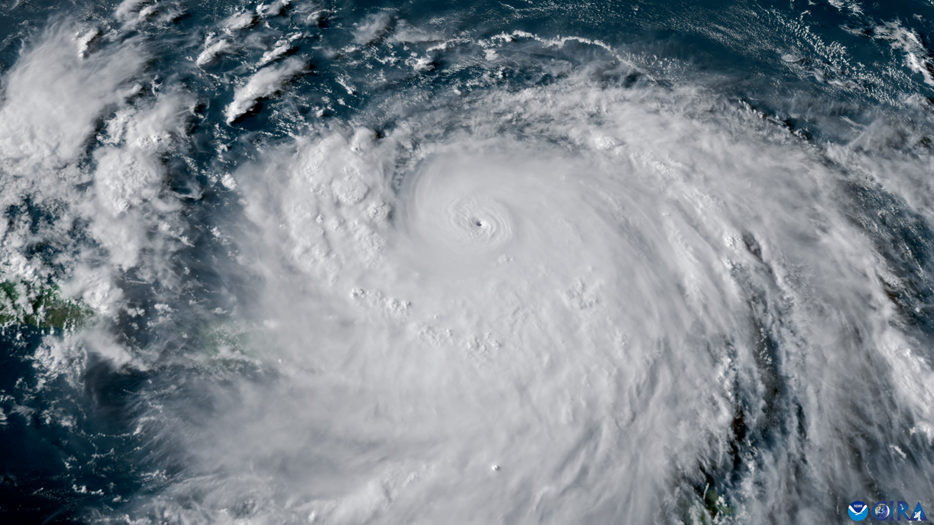
Hurricane Erin dazzled forecasters over the weekend, putting on a spectacular show of strength rarely observed, becoming only the 43rd Atlantic-basin Category 5 hurricane on record and tying Camille in 1969 for the 4th earliest-forming Category 5 ever recorded.

Erin strengthened 85 mph in only 24 hours from a borderline hurricane to a 160-mph Category 5, a dizzying intensification rate only exceeded by three other Atlantic basin hurricanes – Wilma (2005), Felix (2007), and Milton (2024).

Measuring Erin’s intensity change by pressure fall is even more impressive, and its 78 mb drop from 993 mb Friday afternoon to 915 mph by the same time Saturday is only eclipsed by two other hurricanes – Wilma (97 mb in 24 hours) and Milton (79 mb in 24 hours) – both October hurricanes.

Thankfully, Erin’s rapid strengthening happened largely over water as its center passed about 100 miles north of the northern Leeward Islands and some 180 miles northeast of the U.S. Virgin Islands and Puerto Rico on Saturday.
Erin was a remarkably small hurricane, a common feature of our strongest hurricanes, with maximum winds extending out from the center only about 3 miles (for the average hurricane, the radius of maximum winds is closer to 20 miles).
With hurricane conditions extending only about 25 miles south of Erin’s center, no sustained hurricane winds were observed through the islands as Erin passed to their north and east over the weekend.
As we previewed in Friday’s newsletter, gusty squalls in Erin’s trailing rainbands did bring tropical storm winds to Puerto Rico and the U.S. Virgin Islands, however. Gusts to 53 mph were observed in Culebra in Puerto Rico and 49 mph in Charlotte Amalie on Saint Thomas in the U.S. Virgin Islands, according to the National Weather Service. Erin’s gusty winds knocked out power to over 150,000 customers in Puerto Rico (~10% of the island) over the weekend, according to LUMA Energy, but most customers had power restored as of Monday morning.
Tortola in the British Virgin Islands reported almost 10 inches of rain on Saturday from Erin and widespread flooding was reported throughout the islands where flood watches remain in effect today. Conditions in the islands should dry out by tomorrow as Erin continues to pull away.
Rare pictures from inside Erin’s eye
Both Air Force and NOAA hurricane hunters flew Erin nearly round-the-clock over the weekend, sending back spectacular pictures and data critical to hurricane forecasters.
Among data collected was radar from inside the eye that showed with stunning detail intense mesovortices rotating around Erin’s inner eyewall Saturday morning.

These fingers curling inside the inner eyewall are rarely observed on radar since they only occur in our strongest hurricanes. They not only play a crucial role in extreme episodes of intensification, but are also associated with extreme, tornado-like winds at the surface and are exceptionally dangerous to encounter. It’s one of the main reasons you should never venture outside in the eye of a hurricane if sheltering-in-place.
Because Erin’s eye was so small, hurricane hunters also captured dramatic photos and videos rarely seen from inside a hurricane. The photo below was taken Saturday as NOAA hurricane hunters passed into Erin’s eye at only about 8,000 feet above the ocean surface.

It shows the extreme gradient of strong winds in Erin at the time, with violent, wind-whipped blue seas in Erin’s eyewall on the right, but much less agitated seas from Erin’s relatively calm eye in the upper-left part of the photo.
NOAA Hurricane Hunters also shared this breathtaking video from their last pass through then Category 5 Erin’s eye.
Simultaneously the Air Force Reserve Hurricane Hunters passed through Erin’s eye, capturing this video looking up inside Erin’s eye Saturday morning (August 16th, 2025).
These data and pictures are more than just eye candy for forecasters, helping them quickly correct their initial underprediction in Erin’s intensity early Saturday.

Much larger and powerful Erin to bring dangerous waves and beach erosion
Since its rapid intensification early Saturday, Erin went through a metamorphosis, temporarily weakening, but shedding its smaller eye for a newer, much larger one.
Even though its winds are below its peak Saturday, Category 4 Erin is now a larger and more powerful hurricane. While the center is expected to remain well offshore, the hurricane is expected to bring a period of dangerous seas, significant beach erosion, and life-threatening rip currents up and down the U.S. Eastern Seaboard this week.

Coastal flood watches and hazardous surf advisories have already been hoisted from the southeast U.S. to the Mid-Atlantic and Northeast. As Erin makes its closest approach to North Carolina’s Outer Banks on Wednesday and early Thursday, it could bring seas topping 20 feet or higher just offshore, creating treacherous marine conditions and major coastal problems, including severe flooding and beach erosion, especially oceanside along Highway 12.
Though southeast Florida will see elevated seas and swell from Erin, it will be mostly shielded by the Bahamas, so coastal waters south of Palm Beach County will experience fewer problems from Erin’s passage today and Tuesday.
Erin’s biggest impact on the U.S. will be along the immediate coast from long-period waves and wind-whipped seas, and, as we discussed in newsletters last week, its violent core and strongest winds will stay well offshore between Bermuda and the U.S.
Bermuda may see gusty winds away from Erin as the hurricane passes 300 to 500 miles to their west, but significant direct, non-marine impacts appear unlikely.
Monitoring the next wave for the weekend
Another tropical wave currently in the eastern Atlantic is poised to develop as it moves generally westward toward the northeastern Caribbean for late week into the weekend.

Models are slow on development the next few days but conditions should gradually become more conducive as it moves farther west. The Lesser and Greater Antilles, including Puerto Rico and the U.S. Virgin Islands, should follow the progress of this disturbance this week.

Until the system fully forms, we won’t have a good handle on its future beyond this week, but it’s something we’ll need to monitor for early next week. There are a lot of what-ifs ahead, including island impediments, so be patient and be extra skeptical of longer-range models until we have a defined system.
We’ll of course keep you updated as we have more clarity on the forecast in the days ahead.
CLICK HERE to download the Local 10 Weather Authority’s 2025 hurricane survival guide.
Copyright 2025 by WPLG Local10.com - All rights reserved.
