
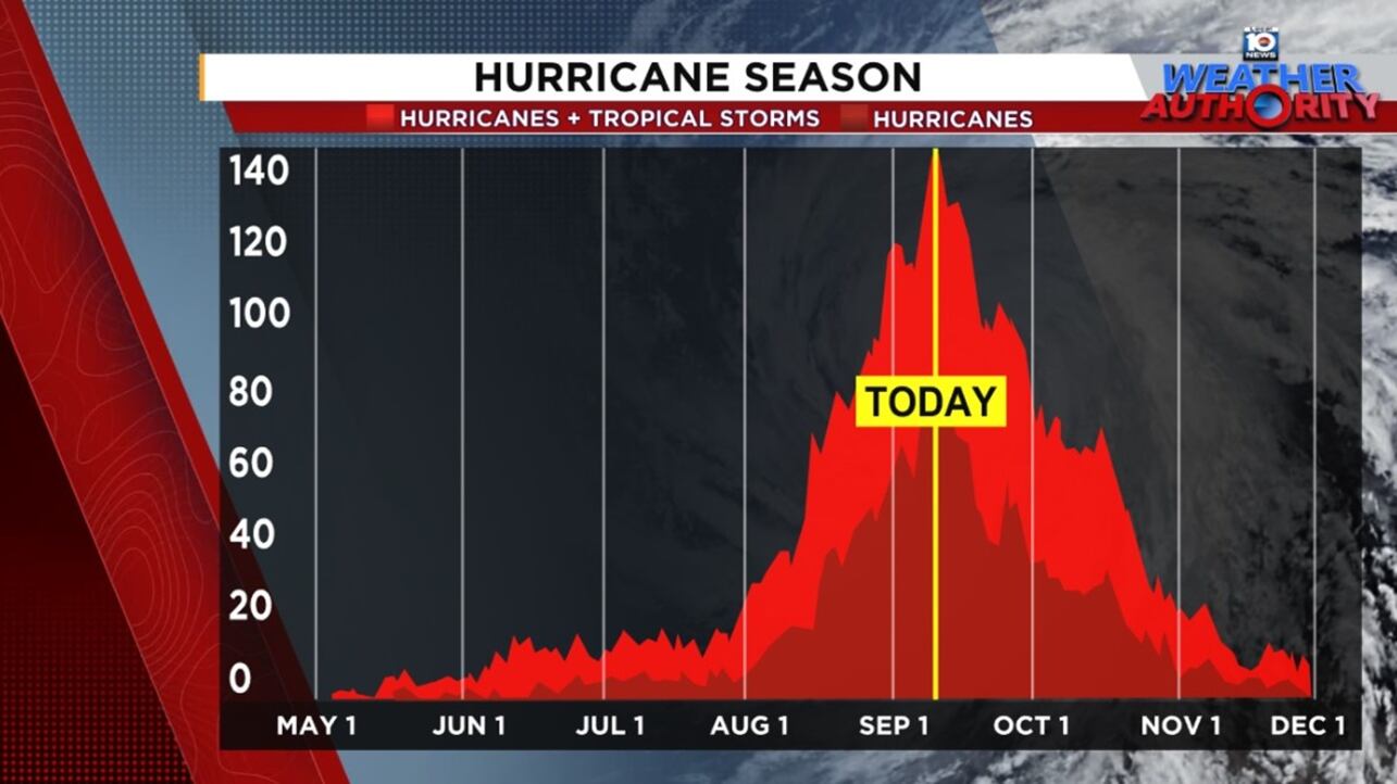
Wednesday is the traditional peak of the hurricane season, the day on which history says we’re most likely to find a named storm in the Atlantic.
Not only isn’t there a tropical depression, tropical storm, or hurricane anywhere to be found across the basin on Wednesday, there’s not even a viable candidate on the National Hurricane Center’s seven-day outlook map.

It’s the first time since 2016 we’ve had no active systems anywhere in the Atlantic basin on Wednesday and only the fourth time this century we’ve recorded a Sept. 10 shutout.
Since the modern satellite record began in 1966, roughly three in four years have observed a named storm somewhere in the Atlantic, Caribbean, or Gulf on Sept. 10. We’ve had as many as three simultaneous named storms on Sept. 10 in years like 2018, 2011 and 2005.
Going back even further, 1961 observed four concurrent named storms (Betsy, Carla, Debbie, and Ester) on Sept. 10 – three of them hurricanes – still the most named storms and hurricanes of any hurricane season at its peak in the 175-year record book.
As we mentioned in Tuesday’s newsletter, what makes this season especially unusual is the absence of any tropical activity in the two weeks leading up to the Sept. 10 peak, a feat that’s only been recorded twice in the modern satellite record (1992 and 1968).
Breaking the silence
There’s increasing support from forecast models that the Atlantic basin reopens for business by next week.
A tropical wave set to roll off Africa this weekend should move into an increasingly conducive eastern Atlantic where gradual development is likely, especially by the middle to latter part of next week.
Both the physics-based European model and its AI-based counterpart are advertising a track into the central Atlantic by the end of next week.

Google’s DeepMind AI newcomer – a strong performer so far this hurricane season – also indicates good development odds next week for the disturbance, and most models for now lift the system north of the Caribbean and its adjacent islands.

The Madden-Julian Oscillation, also known as MJO, will cycle back into a conducive configuration to round out September, so we’ll keep an eye out for prospects in the weeks ahead. For now at least, we don’t see any U.S. threats on the horizon.
CLICK HERE to download the Local 10 Weather Authority’s 2025 hurricane survival guide.
Copyright 2025 by WPLG Local10.com - All rights reserved.
