

Author’s note: This is a special Sunday edition of the tropical newsletter to discuss Tropical Depression Nine, which is forecast to become Imelda later today over the Bahamas.
Forecasts for soon-to-be Imelda continue to trend in a positive direction for the southeastern U.S. and coastal Carolinas, with the consensus of forecast models now slowing the system’s progress, allowing it to get caught by nearby Hurricane Humberto’s wide circulation and swept sharply east and away from the U.S.

As we’ve mentioned in previous newsletters, even with future Imelda offshore, heavy rainfall will continue to be a threat, especially along the coastal plain of the Carolinas from Charleston to Morehead City, from tomorrow through early Wednesday, but extreme higher-end amounts appear less likely.
Nevertheless, residents in the southeast should continue to monitor the forecasts closely, as Imelda’s close approach this week as a hurricane is expected to bring impacts including dangerous surf, life-threatening rip currents, and the possibility of heavy rainfall along the immediate coasts, especially on Monday and Tuesday.
Slow and steady in our favor
Earlier forecasts were quicker to strengthen future Imelda farther northeast than its current position south of Andros Island in the Bahamas.

The subtle delay in development farther southwest combined with a faster-moving Hurricane Humberto over the open Atlantic to its east puts future Imelda south of Humberto’s large circulation rather than north of it, allowing Imelda to get scooped up and slingshot abruptly eastward by late Tuesday and Wednesday.

Though a few outlier scenarios show landfall a possibility, the overnight computer models seem to have sealed the deal that Imelda’s strengthening core will stay offshore the U.S. this week.
What the U.S. can expect from soon-to-be Imelda
As Imelda organizes and strengthens off Florida’s east coast tomorrow, its outer circulation could bring gusty winds to parts of east-central Florida. Tropical Storm Watches remain in place from near Jupiter to just north of Daytona Beach, including places like Melbourne and Vero Beach, for the possibility of winds reaching tropical storm strength (39 mph or higher), mainly right along the immediate coast.
Rounds of squally showers from bands on the western side of Imelda could bring periods of locally heavy rain to the east coast of Florida tomorrow, but widespread flooding concerns aren’t expected and noticeably drier air should wrap in behind Imelda in earnest by Monday afternoon into Tuesday from South Florida northward as Imelda progresses farther up the coast.
Imelda’s rich plume of tropical air will collide with a stalled front along the coastal Carolinas Monday and Tuesday, bringing the threat of several days of heavy rainfall and scattered flash flooding ahead of the storm along the coastal plains of the Carolinas from Charleston, South Carolina, to Wilmington and Morehead City in North Carolina. Rainfall totals should generally stay in the 3- to 5-inch range for these areas.

Imelda will likely strengthen into a hurricane by Tuesday as it briefly stalls several hundred miles east of Florida’s east coast but is now expected to make a hard right turn out to sea into Wednesday.
Dangerous surf and boating conditions will persist off most of the southeastern U.S. this week as Imelda churns up the waters, and minor coastal flooding could occur in areas of onshore flow at times of high tide as Imelda makes its closest pass to the U.S. tomorrow and Tuesday.
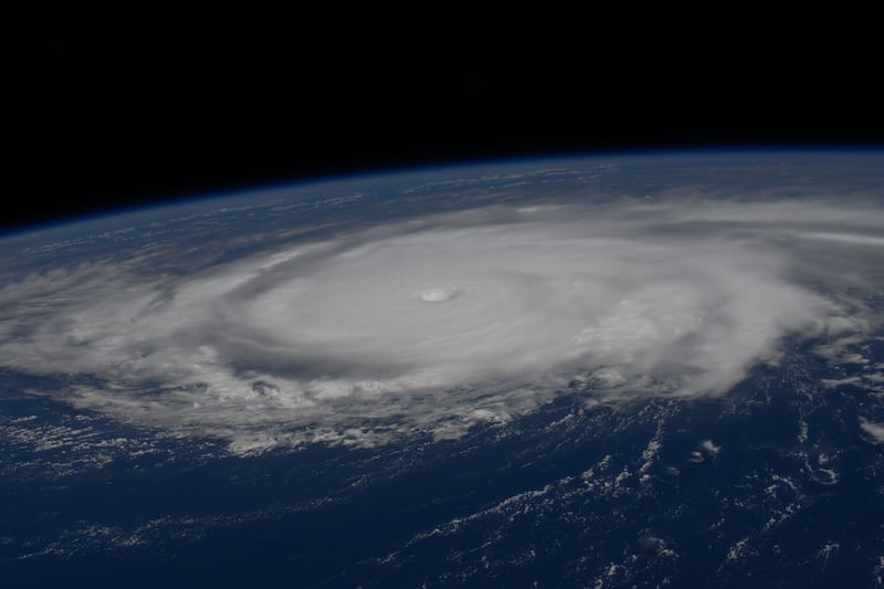
Humberto strengthens into a rare Category 5 hurricane Saturday
Humberto topped the charts as a rare Category 5 hurricane on Saturday, only the 44th Category 5 hurricane recorded in the Atlantic’s 175-year recordbook and the 2nd Category 5 hurricane this hurricane season.

Only eight other hurricane seasons besides 2025 have recorded more than one Category 5 hurricane in a single season. Most of those multiple Category 5 hurricane seasons (66%) have been since 2005. What’s more impressive, of the 3 hurricanes that have formed so far this season, 2 have been Category 5s and the other (Gabrielle) was a Category 4 hurricane.
While we’re below average in the hurricane department this season (we’d typically expect 5 hurricanes by this point in the season compared to the 3 we’ve observed), the ones that have formed have been anything but slouches. It seems quality over quantity is the guiding principle this hurricane season.
Humberto continues to churn over the open southwest Atlantic about 400 miles north of Puerto Rico. Microwave satellite indicates an eyewall replacement cycle in the works early Sunday, with temporary weakening of its maximum winds at the expense of a much larger wind field.
Though Humberto’s powerful core is expected to pass several hundred miles safely west of Bermuda during its closest pass on Tuesday or early Wednesday, it could still bring tropical storm conditions on its eastern flank to the British Overseas Territory.

Humberto will also add to the dangerous surf, swell, and life-threatening rip currents along the eastern U.S. from Florida to the mid-Atlantic this week.
CLICK HERE to download the Local 10 Weather Authority’s 2025 hurricane survival guide.
Copyright 2025 by WPLG Local10.com - All rights reserved.
