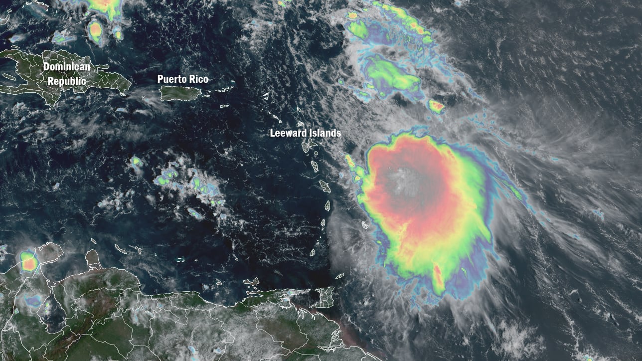
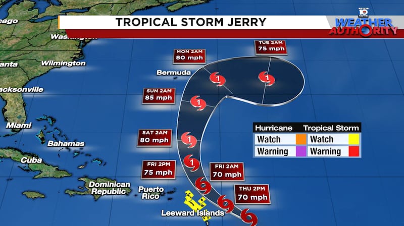
Despite a lopsided and disheveled appearance, Tropical Storm Jerry’s winds have gradually ticked up and it’s expected to be just shy of hurricane strength as its center curves north of the northern Leeward Islands along the northeastern edge of the Caribbean later today.
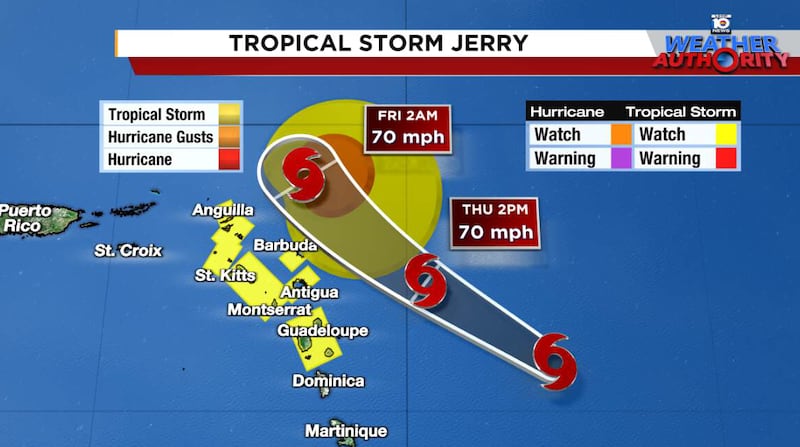
Nearly all of its strong winds are to the east of its center, with virtually no winds above tropical storm strength (39 mph or stronger) on its southwestern side, so sustained tropical storm conditions should largely miss the islands as it passes to the north.
That said, as Jerry pulls away from the islands late tonight and early Friday, it will drag its weather-heavy southeastern tail through parts of the Leeward Islands, including places like Antigua and Barbuda, Saint Martin, Sint Maarten, St. Kitts, Nevis, Montserrat, and Guadeloupe, which remain under a Tropical Storm Watch for the possibility of winds gusting above 39 mph.
Jerry’s squally tail will also bring the threat of heavy rainfall and flash flooding, particularly in areas of steep terrain, to parts of the Leeward Islands and Virgin Islands through early Saturday.
Jerry knocked out to sea courtesy of a developing nor’easter
The much-anticipated cold front passage through Florida this weekend – ushering in a South-Florida-style taste of fall, with noticeably drier and refreshing weather by Sunday – will also help kick Jerry out to sea.
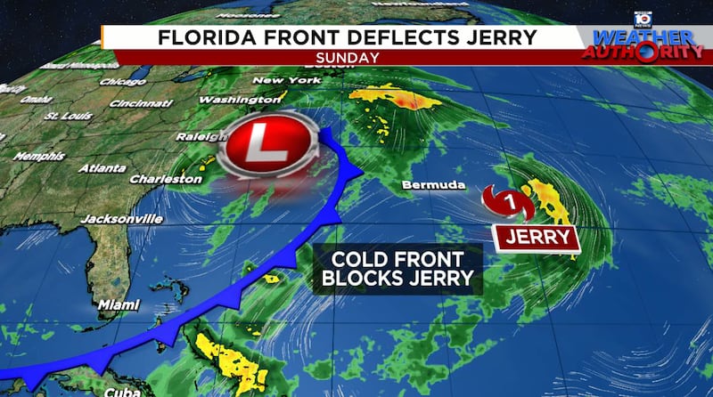
Not only is Jerry not a threat to the U.S., but it will also pass safely east of Bermuda, which could use the break after being clipped by Imelda last week.
The catalyst for the earlier-than-average fall frontal passage for South Florida is a developing non-tropical coastal storm off the Carolinas this weekend, something we’ve discussed in earlier newsletters.
The low-pressure system will morph into a quasi-nor’easter by Sunday, bringing widespread gusty winds above 45 mph and periods of heavy rain up and down the U.S. Eastern Seaboard from the Carolinas to southern New England.
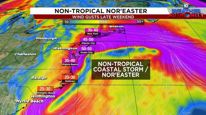
Major coastal flooding and significant beach erosion will accompany the strong and persistent onshore winds and high surf.
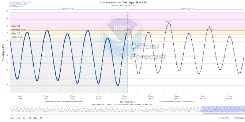
Coastal flooding has already begun in parts of the Carolinas – including places like Charleston, Wilmington, and Wrightsville Beach – from strong so-called gradient winds (winds caused by building high pressure behind the cold frontal passage). The worst coastal flooding for the Carolinas will likely come during the late morning to noontime high tide cycle Friday. Charleston in particular is at risk for multiple rounds of moderate to major flooding into the weekend.
As the coastal storm cranks up this weekend, major coastal flooding will continue to spread northward into the Mid-Atlantic and northeast coasts by Sunday afternoon and Monday, peaking around the time of high tides.
It’s worth reiterating that the storm will start decidedly non-tropical this weekend, with connected fronts and most of its strengthening happening from the jet stream level, not from the ocean. It’s possible it could gradually shed its frontal features and take on characteristics of a hybrid or subtropical system by early next week.
That process would take a little time and still looks like only an outside possibility for next Monday or Tuesday. Though a transition into a subtropical system would garner a name – the next name is Karen – the prolonged and potentially damaging wind-driven weather for the east coast won’t change regardless.
Invest 96L in uncharted waters
The only other suspicious area today is out of bounds in the high latitudes of the north Atlantic. A non-tropical area of low pressure – designated Invest 96L – is producing tropical storm conditions northwest of the Azores Islands.
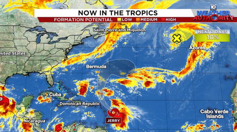
The low-pressure system is trying to cook up some convection near its circulation center, so there’s a very narrow window for it to briefly become a tropical or subtropical system today or tomorrow. It’s worth noting that no tropical cyclone in the 175-year hurricane history books has formed as far north and east as 96L.

If anything forms, it would be short-lived and poses no threat to land.
Copyright 2025 by WPLG Local10.com - All rights reserved.
