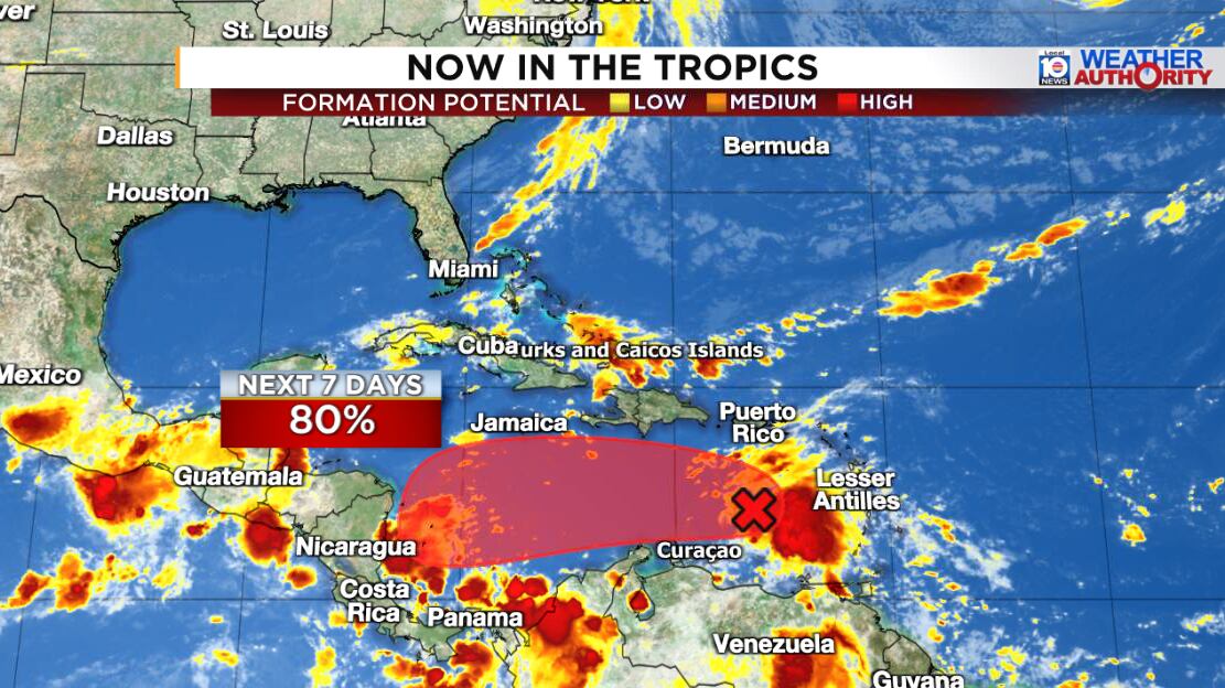
A tropical wave that moved into the eastern Caribbean on Sunday – designated Invest 98L by the National Hurricane Center on Saturday – is becoming increasingly organized and will likely become a tropical depression or tropical storm in the next day or two as it slows over the central Caribbean.
The next name on the list is Melissa.

Forecast models are generally bullish on steady strengthening as the system slows to a crawl over the warmest waters of the Atlantic basin and upper-level winds begin to ease up.

Where it heads thereafter remains unclear as future Melissa gets caught in a tug-of-war between opposing steering currents.
At this time, the more likely outcome is the system eventually gets pulled northeastward by a dip in the jet stream toward Haiti and the Dominican Republic or eastern Cuba come late week into the weekend.

This is the scenario depicted by the AI model camp – including Google’s DeepMind and the European Centre’s Artificial Intelligence/Integrated Forecasting System or AIFS – and the American GFS ensemble system.

On the other hand, the conventional physics-based European model – one of our historically better performing and battled-tested forecast models – is insistent on a trudge westward toward Central America into the weekend, but as a snail’s pace that keeps it hanging around over the southwestern Caribbean into early next week.

Future Melissa’s glacial pace this week ups the ante on a prolonged heavy rain and pronounced flood threat to parts of the Caribbean – from eastern Cuba and Hispaniola to Central America – so we’ll need to monitor the progress of those trends in the days ahead.
Could future Melissa be a problem for the mainland U.S.?
As it stands, none of our model guidance shows future Melissa posing any threat to Florida or the mainland U.S.
As we’ve discussed in previous newsletters, late October and early November hurricane strikes on the mainland U.S. can happen (and have happened), but they’re the exception, not the rule.
The subtropical jet stream has sunk deep into the lower reaches of the Gulf and seems content on parking itself there for the foreseeable future. Strong upper-level winds associated with this subtropical jet will continue to act as a staunch barrier against would-be threats, tearing apart anything trying to get close to the U.S. coastline.

Of course, we never like to see tropical systems fester and try to exploit the occasional chink in the late-season armor, so the faster we can bid farewell to would-be Melissa, the better.
For now, this is a concern for Caribbean interests – from Honduras and Nicaragua to parts of Cuba, Jamaica, Haiti, and the Dominican Republic – not us stateside in the U.S.
The northern reaches of the system could enhance periods of heavy rain across Puerto Rico and the Virgin Islands today and Tuesday but most of the heaviest direct rains should stay south.
Although future Melissa isn’t expected to pose a direct threat to Puerto Rico and the U.S. Virgin Islands, if it takes the northeast escape hatch toward Hispaniola, these areas could see enhanced rainfall along its eastern flank to end the week.
Quiet elsewhere
As we would hope for the third week of October, the tropics will stay quiet elsewhere for the foreseeable future.
Copyright 2025 by WPLG Local10.com - All rights reserved.
