

Author’s note: The taxpayer-funded tools from NOAA I consulted to provide the forecast information and analyses in today’s newsletter include wind analyses from the University of Wisconsin’s Cooperative Institute for Meteorological Satellite Studies (CIMSS). CIMSS is one of over a dozen weather and climate facilities slated for elimination in NOAA’s 2026 proposed budget.
We continue to follow the progress of Invest 93L, an area of low pressure that moved from the Atlantic across the northern Florida peninsula on Tuesday and is now scraping westward through the state’s panhandle along the northern Gulf Coast.
It’s unclear whether 93L will fully reemerge over water in the days ahead, but NHC is maintaining a medium chance for development if it does so.
Regardless, heavy rainfall and a growing flood threat stretching from northwest Florida to Louisiana and as far west as southeast Texas is the main focus today through Saturday.
The most serious flood threat will likely come Friday across areas of south-central and southwestern Louisiana. The National Weather Service Weather Prediction Center outlines an area at moderate risk (level 3 of 4) of flash flooding on Friday that includes Lake Charles, Lafayette, and parts of the Baton Rouge metro.
This indicates the likelihood of numerous flash flooding from heavy rainfall totaling up to 15 inches through Saturday, according to local National Weather Service offices.
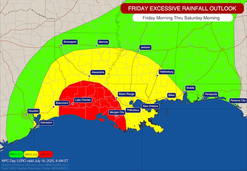
Rainfall coverage will ramp up especially on Thursday and into Friday for these areas and already flood watches have been posted.
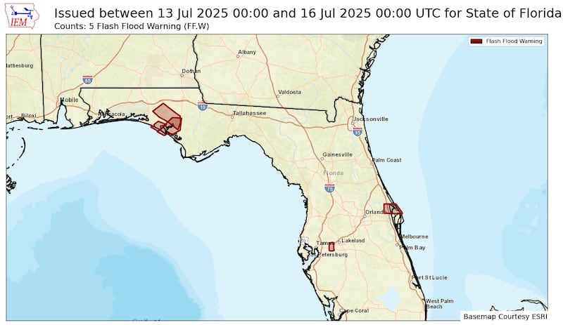
So far, 93L has dragged a corridor of mostly beneficial soaking rains through the Florida peninsula this week, but some locations along the state’s I-4 corridor like Plant City picked up double-digit totals from slow moving storms on Monday. Remarkably, despite all the heavy rain this week, only 4 flash flood warnings were issued statewide across Florida, with most on Tuesday but none across South Florida, a testament to the severe drought we’ve been experiencing much of the year.

Land impediments to development
The still broad and weak circulation of Invest 93L was straddling the coast along Florida’s panhandle Wednesday morning.
Forecast models keep the center near or over last today and tomorrow which should limit or prevent further development as the system tracks westward.

If the low pressure center reemerges back over the northern Gulf, especially tomorrow, it may have a brief window to develop before moving fully inland over Louisiana on Friday.
As we’ve discussed all week, models remain lukewarm on development even over water and high-end scenarios don’t take 93L much beyond a borderline tropical storm. If it ekes out a name, the next name would be Dexter.
CLICK HERE to download the Local 10 Weather Authority’s 2025 hurricane survival guide.
Copyright 2025 by WPLG Local10.com - All rights reserved.
