Despite steady strengthening on Thursday to near hurricane strength, Erin struggled overnight, with hurricane hunters finding a degraded core during pre-dawn missions Friday.
The interruption, however, was likely only a temporary speed bump, and robust thunderstorm activity near the center and a closed eyewall reported in the most recent NOAA hurricane hunter mission suggest renewed strengthening on the horizon. The forecast calls for Erin to become a hurricane by later today, with its center passing about 150 to 200 miles north of the northeastern Caribbean islands this weekend.
Even though Erin’s core is expected to remain well offshore, tropical storm watches have been issued for parts of the Leeward Islands – including places like Anguilla and Barbuda, St. Martin and St. Barthelemy, Saba and St. Eustatius, and Sint Maarten – ahead of Erin’s closest point of approach on Saturday. A Tropical Storm Watch means tropical storm conditions (winds of 39-73 mph) are possible, in the case of Erin, within the next 24 hours.
Erin will bring dangerous surf and locally heavy rain and gusty winds from outer rainbands to the U.S. Virgin Islands, Puerto Rico, the Dominican Republic, and Haiti this weekend as it passes by to the north and turns into the western Atlantic.
For now, the core of Erin is expected to turn east of the Turks and Caicos and southeastern Bahamas but these areas should monitor the forecasts closely this weekend for any changes and prepare for periphery effects like dangerous seas and outer squalls regardless.
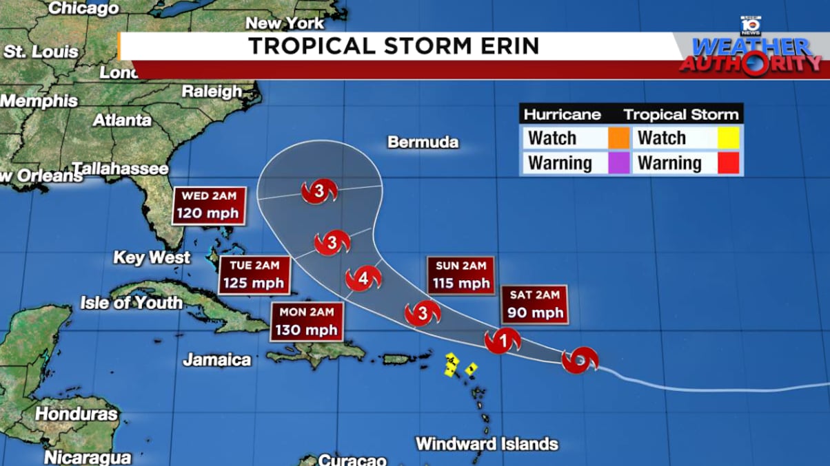
Erin still on track to pass between Bermuda and the Eastern U.S. next week
Forecast models continue to call for a gradual turn northward and eventually a sharper turn to the northeast by mid next week, which would keep a potentially powerful major Hurricane Erin safely east of the eastern United States.

All of our best consensus aids show Erin turning safely east of the United States next week, but it’ll be a much closer call for Bermuda which could land on the stronger eastern side of Erin, depending on how close its center tracks by Wednesday into Thursday.

For the U.S. the most likely impact will comes along the coast from the long swell of a powerful offshore hurricane. The waters all along the east coast will be churned up and beachgoers will want to avoid the waters with the likelihood of dangerous and potentially life-threatening rip currents. North Carolina’s Outer Banks should follow the forecast especially into next week as a track farther west could mean more problematic coastal conditions – including coastal flooding of low-lying areas – next week.
Erin undershoots intensity forecasts so far
Although Erin strengthened steadily on Thursday, it’s so far largely underperformed intensity forecasts. The 3-day intensity forecast from NHC and other reliable intensity models has missed high by about 25 to 35 mph, double or triple the average error of the past five years.

Though Erin struggled some overnight, it seems to be quickly reestablishing its core this morning. Aside from a touch of nearby wind shear this weekend, conditions look to favor robust strengthening, especially as Erin moves over increasingly warmer waters.
Our most reliable intensity models continue to show Erin reaching major Category 3 or Category 4 hurricane status by late weekend or the start of next work week.

Feisty Invest 98L moves inland over northern Mexico and South Texas today
A strong tropical wave moving through the southern Gulf – designated Invest 98L – will be spreading heavy rains to parts of northeastern Mexico and South Texas today and Saturday.

Though hurricane hunters investigating the disturbance on Thursday didn’t find enough organization to upgrade it to a tropical depression or named storm, there’s an increasingly narrow window today for it to become a short lived depression or storm before moving inland later this evening.
As with any tropical system, we’ll need to watch for locally heavy rainfall and isolated flash flooding, but overall the rain will be of the beneficial variety for parts of drought-stricken Deep South Texas.

CLICK HERE to download the Local 10 Weather Authority’s 2025 hurricane survival guide.
Copyright 2025 by WPLG Local10.com - All rights reserved.
