
As we’ve been advertising since early last week, the Atlantic is poised to pick up the pace as we round out September.
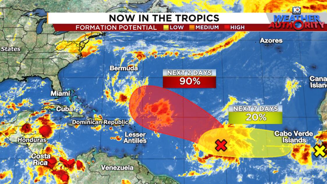
The leading disturbance that we’ve been tracking – a tropical wave designated Invest 92L by the National Hurricane Center – is on track to become a tropical depression or named storm in the coming days while a second tropical wave exiting Africa today could develop by the weekend or early next week.
Neither system is expected to pose any threat to land in the coming week, but models indicate 92L could grow into a powerful hurricane as it rounds the western side of the subtropical high-pressure steering, perhaps posing a close call or direct threat to Bermuda come mid to late next week.

Interests in the British Overseas Territory will want to continue to monitor the forecasts for 92L. The next name on the list is Gabrielle.
No problems for the U.S. for now
The usual African wave train – the conga line of tropical waves exiting Africa that hits its peak by late August and September – is a little late to the party this season. As we’ve explained in previous newsletters, the Atlantic has so far struggled with bouts of dry and sinking air.
The upshot of this late start is the Bermuda/Azores high, which can steer would-be hurricanes – the famed Cabo Verde hurricanes – toward the U.S., is in a weaker place than it is at the start of the month.


With high-pressure steering not reaching as far west as in early September, systems have a tougher time making it clear across the Atlantic.
This will be the case with 92L and likely the system behind it as they find escape routes north into the Atlantic and away from the U.S.

Of course, Bermuda is often in the crosshairs of hurricanes throughout September and will want to continue to check back on the trends. Most intensity models are bullish on 92L’s future, strengthening it into a hurricane as it rounds the subtropical high next week.

The trailing system will likely follow in 92L’s footsteps, staying north of the Caribbean islands and doesn’t look like it’ll make it too far before also curling into the open Atlantic.
CLICK HERE to download the Local 10 Weather Authority’s 2025 hurricane survival guide.
Copyright 2025 by WPLG Local10.com - All rights reserved.
