
Gabrielle, the 7th named storm of the Atlantic hurricane season, formed late Wednesday morning, the first named storm in the Atlantic since August 28th, breaking a remarkable 20-day stormless Atlantic streak and making it the latest first-forming September storm in over 30 years.

Gabrielle was clinging to life Thursday morning against a series of upper-level low speed bumps that continue to knock it off-kilter with spates of dry air and persistent westerly wind shear.

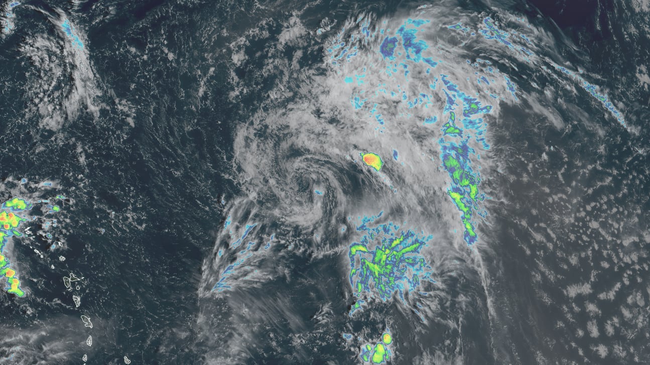
The storm is about as unconventional-looking as it gets for the Atlantic, with nothing more than a weak low-level swirl of clouds surrounded by a huge, comma-like border of disorganized storminess stretching for hundreds of miles from its amorphous center.
The good news is Gabrielle won’t be a threat to the Caribbean islands and will turn into the Atlantic well before reaching the U.S.

Bermuda, on the other hand, will need to keep an eye on the forecasts for early next week, as the impediments this week should lessen by the weekend and allow it to organize more quickly as it rounds the western side of the subtropical high.

For now, models suggest Gabrielle will pass east of Bermuda, but the disorganized nature of the storm suggests higher-than-usual uncertainty in the forecast, so those in Bermuda should check in frequently on the forecasts in the coming days.

Gabrielle barely hanging on
Gabrielle has been a borderline tropical cyclone at best, arguably without enough definition or persistent storminess over its very elongated circulation to be classified as anything more than a strong tropical wave.
There are a host of reasons why the National Hurricane Center generally (with the exception of Potential Tropical Cyclones that pose a near-term threat to land) doesn’t initiate advisories – including the issuance of the ubiquitous forecast cone – until after a system meets their stringent criteria to be deemed a fully-formed tropical cyclone (tropical depression, tropical storm, or hurricane). Chief among them is center reformation – common with systems like Gabrielle with either ill-defined and elongated circulations or sporadic or absent storminess over their centers – which can wreak havoc on forecasts.

We’ve already seen center jumps with Gabrielle and expect more ahead as it tries to find its footing over the next few days. These center reformations are difficult to forecast and a jump here or there can lead to wild swings in future track.
Thankfully Gabrielle will stay harmlessly over water through the weekend, but its ill-defined and naked cloud swirl means the forecast is more uncertain than usual. Interests in Bermuda will want to follow the trends as models do show Gabrielle becoming stronger and more organized as it makes its closest pass early next week.
No foreseeable threats behind Gabrielle
Another tropical wave trailing Gabrielle in the eastern Atlantic has a low chance of development in the week ahead.

Forecast models are universally unimpressed with this one’s development chances and regardless it poses no threat to land areas in the coming week.
Copyright 2025 by WPLG Local10.com - All rights reserved.
