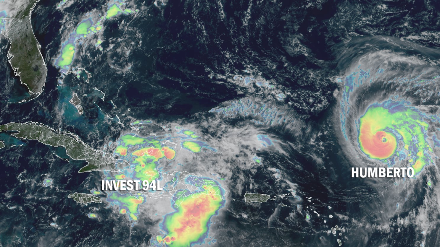
Humberto rapidly strengthened to a hurricane early Friday and is forecast to ramp up into a formidable major (Category 3 or stronger) hurricane this weekend, but it’s the disturbance to Humberto’s west that’s expected to develop and threaten the southeast U.S. – likely as Imelda – by late weekend and early next week.

Though still entangled with the mountainous terrain of Haiti and eastern Cuba, the strong disturbance dubbed Invest 94L will lift northward into the Bahamas today and Saturday, where conditions will favor the formation of Imelda, the next named storm.
Just how strong Imelda becomes is complicated by the orientation of upper-level winds associated with a sharply tilted jet stream dip over the northeastern Gulf. Until the system pulls away from land and consolidates a defined circulation either later today or on Saturday, we won’t know where it’ll stand relative to the upper-level wind configuration that’ll dictate its future strength.

Nevertheless, guidance is in good agreement with at least steady organization and strengthening of Imelda this weekend as it stays east of Florida then possibly bending back west toward the Carolinas and southeast U.S. by next Monday into Tuesday.

Growing concern for major flood threat to the Carolinas
We first discussed in this newsletter on Wednesday the pattern that could promote an upcoming flood event regardless of 94L’s development. The signals for a significant heavy rain and flood risk continue to grow for parts of the southeast, especially for the South Carolina Lowcountry to North Carolina and southern Virginia.
The setup this weekend could produce a Predecessor-like Rain Event or PRE well ahead of future Imelda. A PRE is a heavy rainfall event that can occur hundreds of miles north of a tropical system from a channel of rich tropical air flowing toward a frontal zone.

These PREs are usually worsened by the presence of a nearby upper-level area of low pressure – like the one forecast this weekend over the Tennessee Valley – that help trigger the atmosphere to wring out the copious tropical moisture overhead. An extreme version of this happened last September in western North Carolina ahead of Hurricane Helene.
The other concerning part of this forecast for heavy rainfall is the possibility that future Imelda could slow or stall as it approaches the coastal Carolinas on Monday and Tuesday. This is a scenario favored by some of our better-performing forecast ensembles like Google’s AI-based DeepMind hurricane model and the European model ensemble system.


We won’t be able to nail down the details of the flood threat until we have a better sense of how much future Imelda might strengthen and where it will track, but interests from southeast Georgia through the Carolinas and into southern Virginia should closely monitor the forecasts this weekend. Expect forecast rainfall totals to increase as we iron out the details in the days ahead.

Humberto rapidly strengthening over the central Atlantic
Humberto is wasting no time strengthening today. It became a hurricane earlier today and already has cleared out an impressive eye as explosive thunderstorms encircle the center.
The borderline Category 2 hurricane is well on its way to major (Category 3 or stronger) hurricane status and the forecast now calls for it to top out as a formidable Category 4 hurricane this weekend over the western Atlantic.

The good news is models suggest the core of Humberto should split the uprights between Bermuda and the U.S. next week, but the hurricane will pass close enough to Bermuda to bring bands of heavy rain and strong winds to the British Overseas Territory by next Tuesday into Wednesday.

Residents and interests in Bermuda will want to follow this one closely, as Humberto is expected to be a powerful hurricane as it makes its closest approach next week.
Although Humberto’s nearby passage could possibly slow future Imelda as it approaches the Carolina coast, as we discussed in Thursday’s newsletter, the two systems should maintain enough distance that they don’t interact significantly.
It’s worth noting that if Humberto strengthens into a major hurricane this weekend as forecast, it would be the first time since 1935 that the Atlantic has gone 3 for 3 in the first 3 hurricanes of the season becoming majors (Category 3 or stronger).
Gabrielle wallops the Azores
Although Gabrielle technically lost its tropical characteristics yesterday as it approached the Azores, transitioning into a powerful extratropical storm, its center ripped through the central group of the Portuguese islands, bringing wind gusts to 122 mph at Horta Airport, which is located at about 118 feet elevation on Faial Island, around 5 AM local Friday (1 AM ET Friday).
The center of the now extratropical storm is several hundred miles east of the Azores and quickly accelerating away. The weakening extratropical storm will bring blustery weather, heavy rain, and large waves to coastal Portugal this weekend.
Copyright 2025 by WPLG Local10.com - All rights reserved.
