Imelda became the 4th hurricane of the 2025 hurricane season early Monday as it began its anticipated turn eastward only about 250 miles off Florida’s east-central coast.
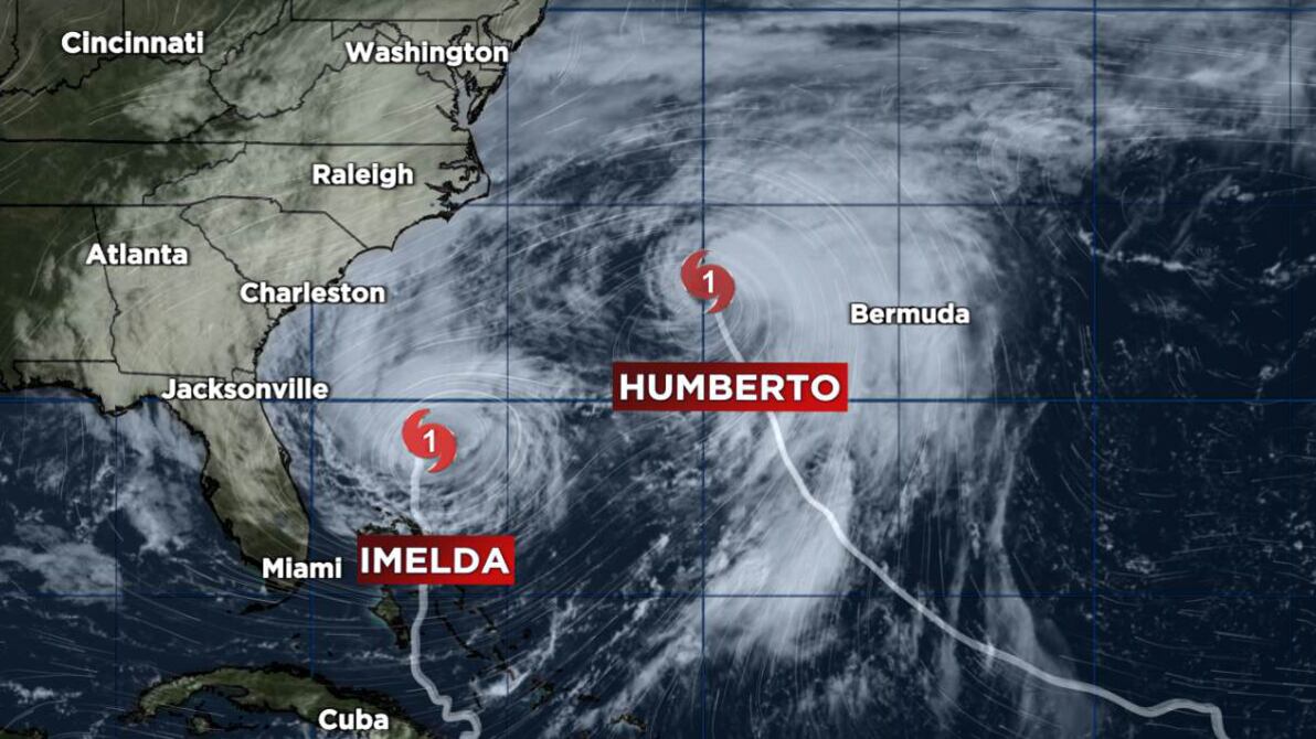
Imelda is being tugged away from the U.S. by the large circulation of neighboring Hurricane Humberto that’s churning less than 500 miles to its northeast. The pair of hurricanes is the closest two hurricanes have ever been observed in the Atlantic in the satellite era (since 1966).

Over the past 60 years, only 9 other pairs of named storms in the Atlantic have been recorded as close as Imelda and Humberto are this morning, with the last such occurrence two years ago to the day with Philippe and Rina, something we wrote about at the time in this newsletter.
Both hurricanes today are suffering at the expense of the other, however, with wind shear worsened by their respective outflows slicing at their cores. Humberto especially is getting pummeled by blistering wind shear which has exposed its center.

By Tuesday morning, Hurricane Hunters flying Humberto were finding it barely holding on to hurricane strength, but its circulation remains large and powerful, whipping up seas from Bermuda to the eastern seaboard of the U.S.

Imelda Bermuda bound
As Humberto passes several hundred miles west of Bermuda today and gets whisked out to sea with the jet stream tomorrow, Imelda will be fast on its heels but unlike Humberto making a beeline for Bermuda for late tomorrow and early Thursday.


Although Imelda will be getting picked up by the jet stream along its path to Bermuda – undergoing an extended transition into a powerful extratropical cyclone – its interaction with the jet stream will initially give it a boost, strengthening it as it closes in on Bermuda as a hurricane.
During its prolonged transition into an extratropical cyclone, models show the development of a so-called “sting jet” on its back side, which could bring extra-violent winds down to the surface as it makes its closest pass to Bermuda late tomorrow into Thursday.

As dry air wraps around into a tropical cyclone during its transition to a non-tropical or extratropical cyclone, a wedge of its moisture-rich core quickly evaporates over the dry slot. That quick drying causes a potent sinking motion, dragging very strong winds from above to the ground. On water vapor, this process usually results in a pointed stinger appearance – resembling an insect’s stinger – on the back side of the cyclone.
Sting jets usually happen over water, where extratropical transition or strong extratropical storms most commonly develop. They most commonly happen over land in western Europe, parts of the UK, and Ireland.
Conditions should improve quickly in Bermuda on Thursday as Imelda pulls quickly away.
Cabo Verde season extended?
Longer-range models are hinting at the possibility of another system with possible development over the eastern Atlantic in about a week. The hurricane season is getting a little long in the tooth for development this far east, but there’s a decent signal in model guidance.

This wouldn’t pose any immediate threats to land and for now models are mostly quiet for the next week or so closer in to the U.S.
Copyright 2025 by WPLG Local10.com - All rights reserved.
