

The 2025 hurricane season that hit the pause button for nearly 3 weeks around its traditional peak in September is showing no signs of slowing as we enter its final stretch.
We’ll be watching two areas into next week – one closer to home here in South Florida and another over the eastern and central Atlantic – for possible development.
The good news is the system closest to us in Florida doesn’t pose a significant development risk but will keep us in a wet pattern and aggravate rainfall totals over the weekend.
Meanwhile, forecast models are increasingly enthusiastic about developing another potentially potent storm by late next week or next weekend (weekend of October 11) as it nears the islands of the eastern Caribbean.
Closer to home
An area of low pressure that’s formed along a stalled front dangling over the western Atlantic near the Bahamas will be the focus for continued wet weather across South Florida this weekend.

Strong wind shear in the vicinity plus the low-pressure’s eventual movement over Florida’s peninsula this weekend make development a long shot at best, but it will help to trigger repeated rounds of storms with locally heavy rainfall along Florida’s east coast.

The highest rain totals will span the length of Florida’s I-95 corridor, with the greatest threat for flooding rains in east-central Florida, from Jupiter northward to Daytona Beach this weekend.

Growing development odds over the central Atlantic next week
A disturbance rolling off Africa today is expected to gradually develop next week as it tracks through the central Atlantic.
Forecast models are bullish on its odds, particularly deeper into next week and into next weekend (weekend of October 11) as it nears the easternmost islands of the Caribbean.
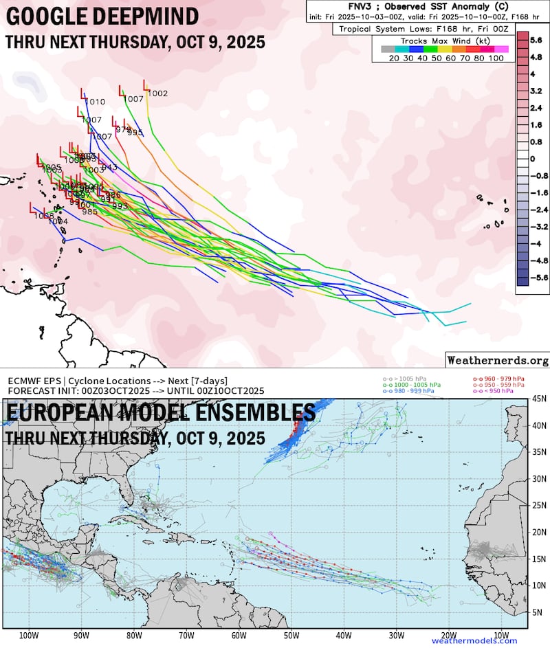
It’s less common to see development over the deep tropical Atlantic in October than September but far from rare. As we discussed in yesterday’s newsletter, more often than not these systems turn into the open Atlantic or threaten the islands, but rarely make it clear across the Atlantic this late in the season.
There are several reasons to be bullish on this one. Our global models are advertising a dearth of wind shear by next weekend and into the following week (week of October 13) as it approaches the western part of the Atlantic.
This is consistent with the progression of the Madden-Julian Oscillation as well, which will be in a conducive configuration by the middle of the month.
It’s too soon to know details, but interests in the islands from the Lesser Antilles to Puerto Rico and the Virgin Islands should monitor the forecasts next week.
Copyright 2025 by WPLG Local10.com - All rights reserved.
