

MONTEGO BAY, Jamaica — Category 5 Hurricane Melissa set a collision course early Tuesday with Jamaica and made landfall at New Hope, Jamaica, on the island country’s southwest coast at peak strength around noontime local on Tuesday.
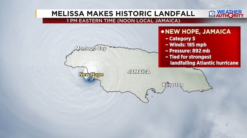
At landfall Melissa’s maximum winds were estimated at 185 mph, tying Dorian in 2019 and the unnamed 1935 Labor Day hurricane as the strongest recorded hurricane to make landfall in the Atlantic basin.

Melissa’s catastrophic core is sawing a devastating path across western Jamaica on Tuesday, though its strongest winds will remain west of the country’s capital and population center in Kingston, where winds should stay below hurricane strength on Tuesday.
Montego Bay on Jamaica’s northwest coast will see damaging hurricane conditions (winds of 74 mph or stronger) for the afternoon and evening hours Tuesday, but Melissa’s catastrophic 13 foot or higher storm surge will be confined to its southern coast and centered on Black River, about 5 to 10 miles east of where Melissa came ashore.
Highest winds directly measured in a hurricane with a hurricane hunter scare
Melissa proved notably resilient to the internal processes that often interrupt ultra-intense Category 5 hurricanes and cause at least temporary weakening within the first 12 hours.
Melissa has been at Category 5 strength for over 30 hours and is the longest-lasting Category 5 hurricane the Atlantic basin has observed since at least Dorian in 2019, which went 30 hours at Category 5 strength over the Bahamas.
Shortly before 10 a.m. ET Tuesday, NOAA Hurricane Hunters flying Melissa dropped an instrument into its powerful southern eyewall that measured an instantaneous wind – an extreme gust – of 252 mph just above the ocean surface.
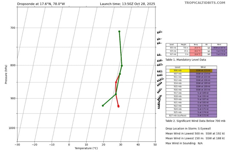
If confirmed, this would be the highest instantaneous wind ever observed inside a tropical cyclone, eclipsing the 247 mph extreme wind gust measured by a dropsonde in Super Typhoon Megi – one of the one of the most intense tropical cyclones ever recorded globally – over the western North Pacific in October 2010.
Hurricane Hunters also measured pressure down to 892 mb during their mission Tuesday morning.

Air Force Reserve Hurricane Hunters experienced extreme turbulence while passing into Melissa’s eye Tuesday morning that required the crew to loiter inside the calm eye in order to perform safety checks on the integrity of the aircraft, according to a statement issued by the 53rd Weather Reconnaissance Squadron.
Though it’s unclear if the WC-130J “Hercules” aircraft sustained any damage, the crew did safely return to their forward operating location in Curaçao.
With a pressure of 892 mb, Melissa ties the 1935 Labor Day hurricane as the third most intense Atlantic basin hurricane on record (by pressure), trailing only Wilma (2005 – 882 mb) and Gilbert (1988 – 888 mb).

Melissa is also tied with Dorian (2019), Wilma (2005), Gilbert (1988), and the 1935 Labor Day hurricane for the second strongest Atlantic basin hurricane on record by maximum winds.
Only Hurricane Allen in 1980 – with estimated 190 mph winds – recorded winds stronger than Melissa.
A narrow corridor of catastrophic winds
Melissa’s most extreme 185 mph winds, with gusts over 200 mph, are within about a 10-15 mile path centered on its eye, so its stairstep movement over Jamaica on Tuesday, with wobbles left followed by wobbles right, will make a world of difference to towns and communities along and near its track, including in places like Montego Bay.
In many respects, Melissa’s corridor of catastrophic wind destruction will resemble a very wide and prolonged tornado in its trek across Jamaica.
Catastrophic rainfall continues across Jamaica and threatens eastern Cuba
Melissa is bringing life-threatening flash flooding accompanied by treacherous landslides across Jamaica today.
Up to 40 inches of rain is forecast locally in Jamaica by the time it’s all said and done.

Melissa isn’t expected to weaken much over Jamaica as it accelerates toward eastern Cuba tonight, where it’s forecast to strike as a still-powerful Category 4 hurricane in the predawn hours on Wednesday. Melissa could be the strongest hurricane to hit eastern Cuba since Matthew in 2016, but with a track farther west over land, it has the potential to be a more impactful hurricane.
Melissa is forecast to bring over 20 inches of rain to parts of eastern Cuba.
Southeastern Bahamas and Bermuda on deck
As Melissa accelerates northeastward on Wednesday ahead of a potent jet stream dip moving through the eastern U.S., it’s expected to bring near-major hurricane conditions (winds nearing 111 mph) to parts of the southeastern and central Bahamas, centered on Crooked Island west to Long Island.
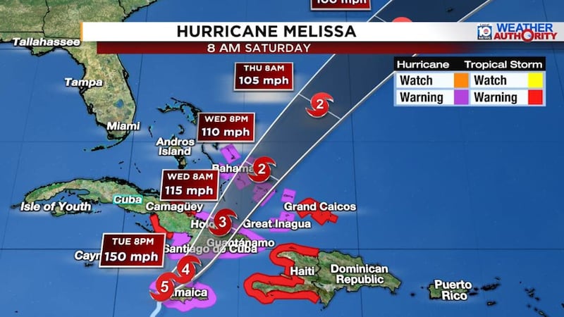
Tropical Storm winds will likely impact the Turks and Caicos, but winds should stay below hurricane strength as Melissa makes its closest pass Wednesday afternoon and evening.
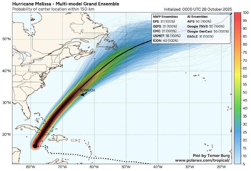
Melissa will be moving very quickly as it passes near or west of Bermuda as a Category 1 or 2 hurricane late Thursday into early Friday.
Hurricane season simmers down behind Melissa
Though hurricane season runs through the end of November, landfall threats, especially to the United States, become far less common once November rolls around.
Long-range forecast models are crickets behind Melissa and the Atlantic looks to simmer down into the waning weeks of the season.
Copyright 2025 by WPLG Local10.com - All rights reserved.
