
The National Hurricane Center continues to monitor an elongated corridor of low pressure stretching down the southeast U.S. coast and into the northeastern Gulf – with its south side tucked away in the elbow of Florida’s Big Bend – for possible tropical development starting this weekend into early next week.
As we’ve been discussing in this newsletter since Monday – two days before the area was first included in NHC’s outlook – the development odds are low here, primarily due to the disturbance’s proximity to and interaction with land and modest to strong bouts of wind shear in the vicinity.
The challenging environmental conditions and disorganized starting place of the disturbance don’t support significant organization, but with near-record warm waters for the time of year in the northeastern Gulf and off the southeast coast, a weak but short-lived tropical depression or low-end tropical storm can’t be ruled out. For now, the odds are stacked against it gathering enough organization to clear those hurdles, however.
Locally heavy rain the upshot regardless
Regardless of development, heavy rain from Florida’s Sun Coast – including the Tampa Bay metro – through the state’s Nature Coast and sweeping Big Bend will be the primary hazard into early next week.

Though heavy rains will start in earnest on Saturday, the heaviest threat will extend from Sunday through Tuesday, including across the interior middle tier of the state and northeast Florida.
Overall totals for now seem manageable and could be beneficial to areas of the state that desperately need an extended period of soaking rains to help relieve its ongoing drought.
That said, these types of tropically-juiced setups can produce very high rain rates exceeding 3 inches per hour, so localized flash flooding is certainly possible, especially in urban areas like the Tampa or Jacksonville metros.
No development expected elsewhere across the Atlantic
A robust tropical disturbance in the far eastern Atlantic just west of Africa also included in NHC’s tropical outlook isn’t expected to develop.
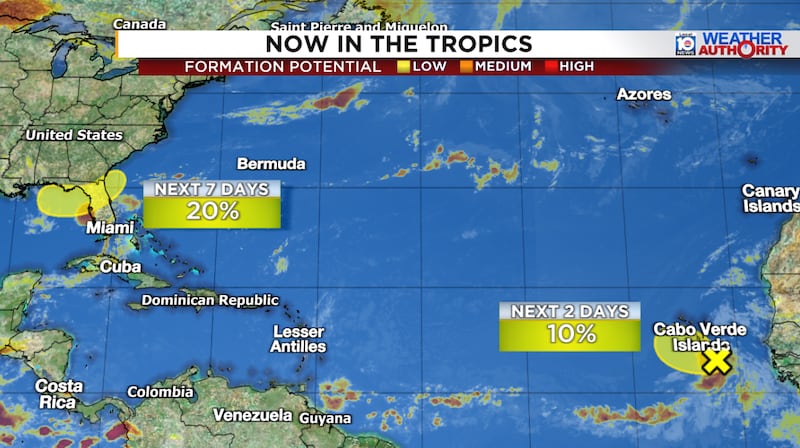
Elsewhere things continue to look quiet across the basin into the waning weeks of July.
NOAA restores critical hurricane tracking satellite
An extended outage of the GOES-19 weather satellite that we first reported in yesterday morning’s newsletter was remediated by Thursday afternoon.
According to my sources at NOAA with knowledge of the situation, the malfunction stemmed from software aboard the satellite platform. The satellite required rebooting to fix the issue which took it offline for approximately 24 hours from Wednesday to Thursday afternoon. During this time, NOAA engineers placed the satellite in what’s known as “safehold” as an emergency protective action to prevent major damage or risk satellite failure.
Thankfully, the issued was resolved expeditiously with no lasting damage to the satellite. GOES-19 is NOAA’s primary weather monitoring satellite for the U.S. East Coast and tropical Atlantic. This satellite is different from the defense-operated, polar-orbiting constellation of hurricane-monitoring satellites that faced early termination last hurricane season. Those satellites continue to operate without interruption after officials issued a last-minute fix last July to address cybersecurity concerns and keep the satellites online.
Copyright 2026 by WPLG Local10.com - All rights reserved.
