
The team of hurricane experts at Colorado State University that regularly issues seasonal hurricane predictions from April to August released its final outlook for the 2026 hurricane season Wednesday morning.
The group continues to call for “well below-average” hurricane activity across the Gulf, Caribbean, and wider Atlantic this year, with increasing confidence that a powerful El Niño in the waters of the eastern Pacific will significantly reduce overall storm activity across the Atlantic basin and lower the odds of a major hurricane hit on the U.S. and coastlines bordering the Caribbean.
CSU’s bottom-line numbers remain unchanged from its July forecast, predicting 9 named storms this season (including the two named storms that have already formed), four hurricanes, and one hurricane reaching Category 3, 4, or 5 strength. The 30-year average is 14 named storms, seven hurricanes, and three Category 3 or stronger hurricanes.
As we’ve covered in this newsletter, wind shear in the western Atlantic and Caribbean region has been running as high as we’ve ever observed in the satellite record (since 1979) and seasonal forecast models like the famed Euro ensemble are forecasting the highest wind shear on record for their hindcast period (since 1981) for September.
The hostile wind shear is being powered by the ongoing El Niño in the Pacific, which continues to outpace our strongest El Niños like 1997, even after adjusting for Wednesday’s warmer water temperatures due to global warming.

It’s a near certainty that this El Niño will be one of if not the strongest on record, even after accounting for climate change.
Though strong El Niño years like this one almost universally dampen hurricane activity in the Atlantic, it’s worth reiterating that it doesn’t reduce hurricanes altogether.
Strong and impactful hurricanes still happen, even during down years (see Joaquin in 2015 which sunk the American cargo ship El Faro, claiming the 33 lives of her crew, and tangentially led to catastrophic flooding in South Carolina), and even if the odds are reduced, lighter years activity-wise don’t give us a seasonal pass.
Nevertheless, this is about as encouraging of an outlook as we could ask for in August. Tropical Atlantic waters are tepid, especially compared to recent hurricane seasons and especially compared to the global tropics, which matters most in terms of sinking air dominating the basin and deterring storm growth.
AI models perk up for mid-August
Since last Thursday, we’ve touched on a disturbance the AI camp of models has been sniffing out over the main development region of the tropical Atlantic (between Africa and the Caribbean) for mid-month.
The signal has stayed relatively consistent since last week, but in recent model runs we’re noticing a subtle uptick in model interest.
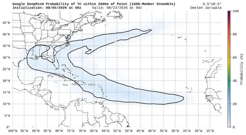
The odds remain low (only around 10% of ensembles members show development) and we’re still a week away from any coherent disturbance we might begin tracking, but the persistence of models along with the subtle uptick means it’s something we’ll be checking back on.
Additionally, the traditional physics-based models and their ensembles, which have been largely quiet, have perked up some in recent runs.
As we’ve stressed before (and an evergreen statement for all potential disturbances more than a week out), this isn’t anything that we need to worry about, but we’ll keep you posted on the trends into next week.
Copyright 2026 by WPLG Local10.com - All rights reserved.
