
Tropical Storm Fay – the 6th named storm of the historically inactive 2026 Atlantic hurricane season – formed quickly over the weekend over the far northeastern Atlantic and made an unexpected run as the season’s first hurricane by Sunday evening.
Ultimately Fay fell just short of the 74 mph hurricane threshold, topping out as a 70 mph tropical storm Sunday night before quickly crumbling to a curtain of wind shear early Monday.
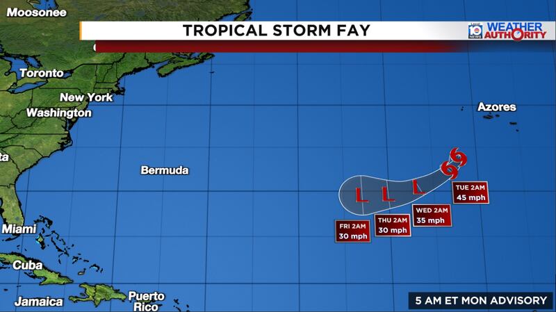
Fay was poorly forecast or missed entirely by our major forecast models late last week. Models mostly keyed in on the disturbance designated Invest 98L over the central Atlantic last week – which we discussed in detail in this newsletter much of last week – while either downplaying or overlooking the potential development of the low-pressure system that became Fay southwest of the Azores.
The National Hurricane Center didn’t first include the disturbance in its outlook until Friday morning – only 24 hours before it formed – and with low odds that sharply rose during the day Friday.
Fay finds a window
Fay formed almost as far north and east as we’ve recorded an Atlantic named storm in September, in a part of the basin that’s historically hostile to tropical development this time of year.

But waters in the area where Fay formed are at record warmth for the time of year and, with a narrow window of light upper-level winds, Fay made the most of its short stint as a tropical system.

Forecast models historically struggle with initially non-tropical systems like Fay that form in the far corners of the North Atlantic and outside of the traditional tropical belt. Back in September 2012, the system that was forecast to top out as a 40 mph Tropical Storm Michael over the open middle Atlantic became 115 mph Category 3 major Hurricane Michael (different from 2018’s catastrophic Hurricane Michael that struck the Florida panhandle) less than three days later.

It’s a good reminder that while hurricane forecasts are one of the best success stories in all of predictive sciences, forecast models can still miss in dramatic fashion, especially for unconventional situations or during seasons that don’t behave like others in the historical record.
Upcoming nor’easter with a small chance of turning tropical
An area of low pressure that’s expected to develop along a stalled cold front over the western Atlantic later this week will drift westward toward the Mid-Atlantic and Northeast U.S. as it strengthens into the weekend.
While the exact track of the low-pressure is still uncertain, the difference in high pressure over Central Canada and the intensifying low to the southeast over the western Atlantic will crank up winds and whip up seas along the Eastern Seaboard from the Outer Banks of North Carolina to New England from Thursday through Saturday. This could produce a prolonged nor’easter-like event for the region, with strong, gusty winds above 40 mph, multiple cycles of coastal flooding, coastal erosion, and periods of heavy rain depending on the eventual track of the low-pressure system.

For now, the system looks to stay non-tropical, but there’s a small chance (~20% chance) its core warms enough so that it transitions to a tropical system later this week into the weekend. Both the AI models and traditional, physics-based models agree on this low probability scenario so it’s something to follow. Regardless, it shouldn’t appreciably change the impacts expected for the coast later this week.
Copyright 2026 by WPLG Local10.com - All rights reserved.
