
The 2026 Atlantic hurricane season is off to one of its slowest starts this century – behind only 2009 and 2007, assuming no additional tropical activity this week as expected.

As we’ve covered in newsletters through the years, however, the amount of tropical activity to-date isn’t a meaningful predictor for seasonal activity ahead, at least in the early months. There are exceptions to this rule, like when we see development east of the Caribbean in June and July, as we previewed in May of 2024 and which became a useful predictor in the wake of Category 5 Beryl a month later.
But things change by August. By the time we reach the end of meteorological summer, how much activity we’ve observed so far does become meaningful in terms of what the rest of the season in September and October may hold.
As you can see in the graph below, which shows the relationship between seasonal tropical activity to-date to overall seasonal activity, the correlation becomes significant in August and approaches a strong correlation (values near 0.5) by the end of the month.
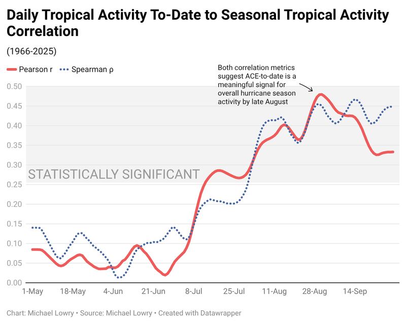
It’s not a perfect way to predict activity ahead (it only explains about 20-23% of the variance), but it’s certainly a useful and meaningful signal, especially when combined with other good predictors like wind shear and water temperatures.
So it’ll be interesting to see how this August pans out, as the environmental predictors (El Niño-induced shear and cooler water temperatures) portend below-average hurricane activity in the months ahead, especially compared to the active and often hyperactive hurricane seasons of the past decade. If August ends with historically low activity to-date, that would add another vote of confidence that the season will continue to struggle into September.
A whole lotta nada for now
If the long-range models are correct, we’ll at least get through mid-August without much to speak of across the Atlantic.
We continue to see a weak signal for a disturbance over the eastern or central Atlantic in a little over a week, especially in the machine learning-based model camps, but those odds haven’t increased in recent runs and remain low for now.

Copyright 2026 by WPLG Local10.com - All rights reserved.
