

An area over the middle Atlantic that we first highlighted in this newsletter last Thursday as the next development candidate was added to the National Hurricane Center’s tropical weather outlook map early Sunday.
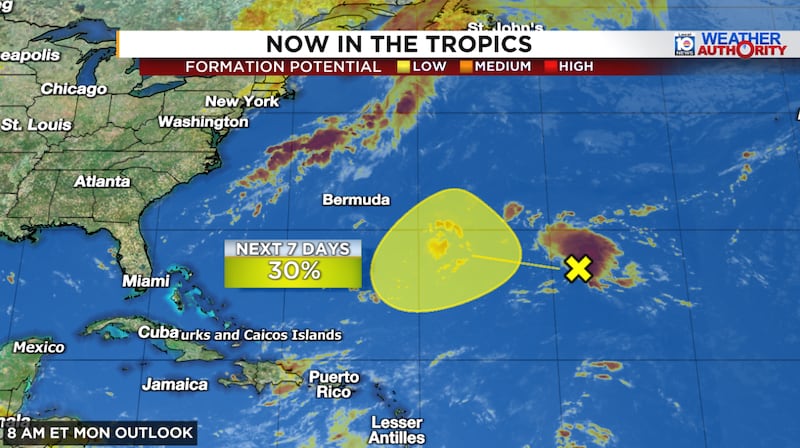
The broad area of low pressure – situated smack dab over the open subtropical Atlantic, an area of the basin we’ve featured in newsletters this season due to its advantageous positioning away from El Niño’s suppressing influence – was accompanied by disorganized storminess early Monday.
NHC indicated low odds of development later this week as it moves toward an area of lighter and more conducive upper-level winds.
AI models versus legacy physics-based models
The newer machine learning-based AI camp of models have been gradually dialing up development odds for this area since late last week but their legacy physics-based counterparts – like the Euro and American GFS – have stayed notably silent.
As of early Monday the conventional Euro ensemble system showed only a handful of development outcomes of the 50 or so scenarios run, taking the under on NHC’s 30%.

In stark contrast, however, Google’s DeepMind machine learning-based ensemble system was taking a very aggressive stance toward development later this week, with odds above 70% for the week, most of which suggest the system could peak as a strong hurricane into early next week.

Though not as bullish on strengthening as DeepMind – perhaps due to a known systematic low-intensity bias that we detailed in our post last Thursday – the Euro AI ensembles are similarly aggressive on overall development odds this week.

The answer is probably somewhere in between but given the thunderstorm activity already building around the broad low-pressure area and the general setup ahead with some alley-oops from a series of jet-stream dips, I’d favor development in this instance.
It’s noteworthy that even in the few physics-based Euro scenarios that show development, the forecast intensities are strong which is likely indicative of an environment supportive of strengthening if a storm gets going.
Nevertheless, this will be an interesting case to see which of our modeling camps – the newer AI models or the conventional physics-based models – handle the potential development (or lack thereof) better.
Interests in Bermuda will want to monitor the progress of the system but otherwise it isn’t expected to pose a threat to land areas in the week ahead.
Copyright 2026 by WPLG Local10.com - All rights reserved.
