Tropical Storm Fay has formed over the Gulf Stream just off the North Carolina coast. This is the earliest an “F” storm has formed by about two weeks.
The previous record was set by Tropical Storm Franklin in the hyper-active year of 2005.
The storms this year are very different from 2005, however. They have all formed from non-tropical systems that acquired enough tropical characteristics to get a name. And none of them got very strong. The early storms in 2005 included multiple hurricanes including one Category 5.
Thursday afternoon, Hurricane Hunters flew into the system and found it just organized enough to be designated a tropical storm.
As of 5 p.m., Tropical Storm Fay had 45 mph winds. It was estimated to be moving north at 7 mph.
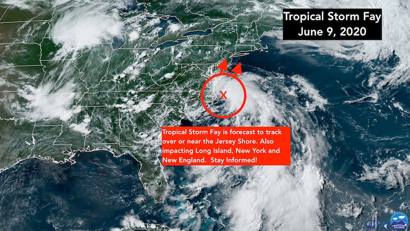
A dip in the jet stream is coming along that will lift Fay almost due north near or over the Jersey Shore and impacting Long Island, New York and New England Friday into Saturday.
Tropical Storm Warnings are in effect for the New Jersey, New York, and Connecticut coastlines. Vacationers need to prepare to stay inside until the storm passes. Surf conditions will become increasingly dangerous tonight.
Even in New York City, winds will become quite gusty with tropical squalls Friday.
The ocean water offshore of the Mid-Atlantic states is much warmer than average this year, which will allow Fay to maintain unusual strength until at least Friday morning, although the atmospheric pattern will become less favorable during the day and Fay is forecast to weaken some before likely landfall in New Jersey or New York.
Everybody from North Carolina to New England should stay in touch will their local forecast. Because Fay is just forming, the forecasts have some uncertainty. Although in this case, the weather pattern seems pretty well established.
The National Hurricane has issued these key messages related to Tropical Storm Fay:
1. Fay is expected to produce 3 to 5 inches of rain with isolated totals of 8 inches along and near the track across the Mid-Atlantic states into southeast New York and southern New England. These rains may result in flash flooding where the heaviest amounts occur. Widespread river flooding is not expected at this time.
2. Tropical storm conditions are expected along portions of the Mid-Atlantic and Northeast coast Friday and Friday night, and a Tropical Storm Warning has been issued for the coasts of New Jersey, New York, and Connecticut, including Long Island.

Copyright 2020 by WPLG Local10.com - All rights reserved.
