
The much-anticipated change in the weather pattern across the Atlantic is finally underway. The wind will start blowing off the ocean later today, with the breeze picking up in earnest later in the week. Afternoon temperatures will be lower, and more moisture will stream in late week and over the weekend.
High pressure, which has been split into three cells over the Gulf of Mexico, the Atlantic and over northern New England, will consolidate and strengthen over the middle of the Atlantic. The flow will once again be established across the ocean from Africa to Florida and the Gulf.
With the high broken up and part of it over the Gulf, the wind flow from the ocean was cut off, and South Florida and parts of the Gulf coast were stuck in an extreme-heat pattern. This change will put things back to normal. It also maintains the flow of dust off Africa, which has been keeping the tropics calm.
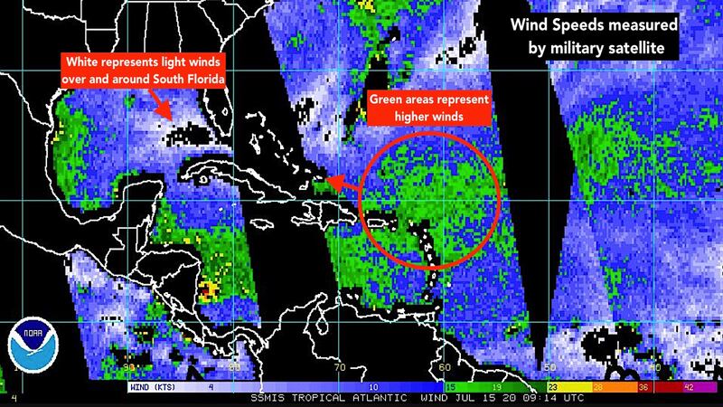
This image from a military satellite that passes over swaths of the Atlantic every 100 minutes or so shows the patch of stronger winds building mid-ocean. That wind surge and accompanying moisture should arrive in Florida about Friday and last into the weekend.
There’s a tropical disturbance over the Caribbean islands, but it’s embedded in so much dust that it’s not visible on the satellite. It represents an area of low pressure in the flow, however, which will contribute to the extra breeze over Florida when it passes by to the south.
Robust tropical disturbances are moving off Africa, but so far, the dust is keeping them from developing. They will bear watching in the next few weeks.
For now, no tropical development is expected through the weekend, at least.
Copyright 2020 by WPLG Local10.com - All rights reserved.
