The weather scenario has four components. Exactly how they will end up working together is unknowable, but broadly speaking, the forecast weather pattern is one that can produce bands of very heavy rain across South Florida. On the current schedule, this would come together about Friday, plus or minus, and last into most or all of the weekend. As always, there are a lot of moving parts, so for now, just be aware.
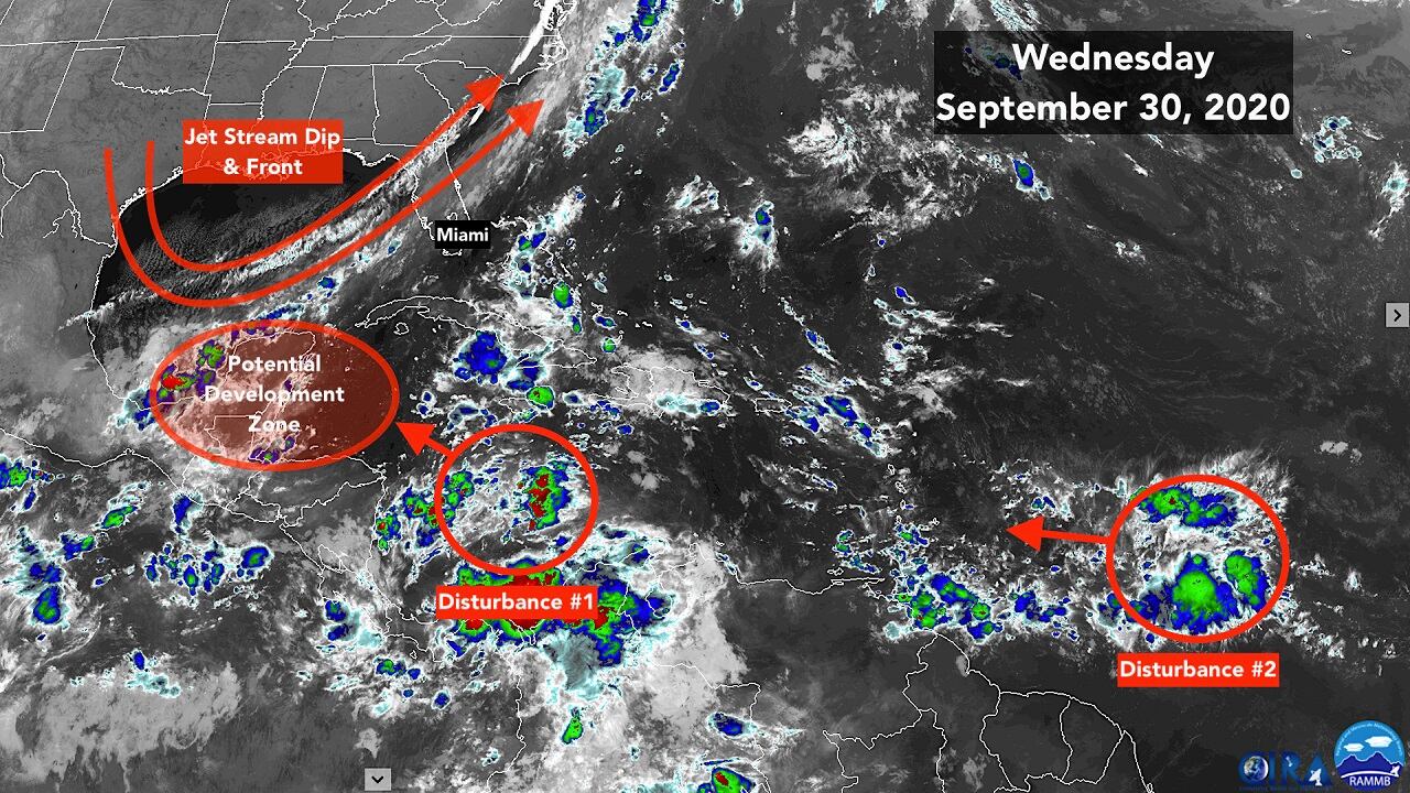
The first ingredient is very disorganized Disturbance #1 that is slowly moving across the Caribbean. It’s not much to look at, but its energy will come into play later in the week when it reaches the western Caribbean.
Second, a bubble of upper-level winds is forecast to develop over the western Caribbean later in the week, about the time Disturbance #1 arrives. This pattern will provide an environment that could support the formation of a tropical depression or tropical storm.
Third, as often happens at the beginning and end of hurricane season, a broad area of low-pressure called a Central American Gyre is forecast to form extending into the southwestern Caribbean and the adjacent Pacific waters. Out of this broad disturbance, sometimes tight circulations develop that become tropical storms and hurricanes – both on the Atlantic and the Pacific side. In this situation, the weak disturbance moving through the Caribbean may become one of those circulations that develops into a tropical depression or tropical storm.
And finally, a sharp dip in the jet stream and its attendant cold front is plunging into the Gulf. The front is forecast to stall across the southern Florida Peninsula.
The jet stream dip is forecast to scoop up tropical moisture related to the disturbance and the Central American Gyre and stream it northeast across South Florida. Fronts are often the focus of heavy rain in these scenarios. The bottom line is the ingredients may come together to produce very heavy rain in areas south of Lake Okeechobee between Friday and Sunday.
In the western Caribbean, the National Hurricane Center is giving the combination of the ingredients a good chance of generating a tropical depression or tropical storm.
The steering currents are weak, and such as they are, they are forecast to push the disturbance over the Yucatán Peninsula in Mexico, keeping it from developing much more.
The main effect in the next several days appears to be the moisture that will be pulled north out of the disturbance, whatever form it’s in, when it combines with the broad Central American Gyre.
Around the weekend, the computer forecast models predict that the disturbance will organize into at least a tropical depression before it moves over or near the Yucatán Peninsula. Even if it develops, soon after that the bubble of supportive upper winds is forecast to move away, so it doesn’t currently appear that the environment will favor a significant storm. But it’s too early to rule anything out.
For now, we’ll see how it develops, and be ready for rounds of heavy rain at the end of the week and over the weekend on top of ground which is already saturated in some parts of South Florida.
Disturbance #2 will slowly track westward into the Caribbean over the next several days. The long-range computer models show a variety of scenarios when it reaches the same broad development zone related to the Central America Gyre around the middle of next week. It’s too early to know more.
Copyright 2020 by WPLG Local10.com - All rights reserved.
