Hurricane Delta pulled itself back together after its encounter with Mexico. Now, as expected, it has grown bigger, and it’s back to Category 3 strength. There’s still a good chance it will weaken some in the hours before landfall late today, but it’s likely to come ashore as a powerful, damaging hurricane.
Bizarrely, it looks like Delta is going to come ashore in southwest Louisiana, in almost exactly the same place where Hurricane Laura hit in August. The size of the storm will be about the same, but it will likely be weaker than Laura, and hopefully weaker than it is now.
The Gulf water near the coast is cooler this late in the year, and the upper-level winds have become increasingly hostile. On the satellite, the flattening effect of those upper winds can be seen on the high clouds on the lower left of the hurricane. The question is, how much can these negative factors disrupt Delta’s well-developed core before landfall?

Even if the winds in Delta’s circulation come down a bit as forecast, the storm is already pushing water toward the coast. The water rise caused by the onshore winds on the right side of the hurricane will still be life-threatening.
The storm surge is forecast to be 7 to 11 feet above normal high tide just to the right of where the center comes ashore. The Gulf water rose 17 feet above the high-tide mark in more-powerful Laura, but obviously, the Delta numbers are still devastating.
Many people in that area are living with tarps on their roofs or in temporary housing. Debris from Laura is everywhere. This is going to mean starting the recovery process all over again.
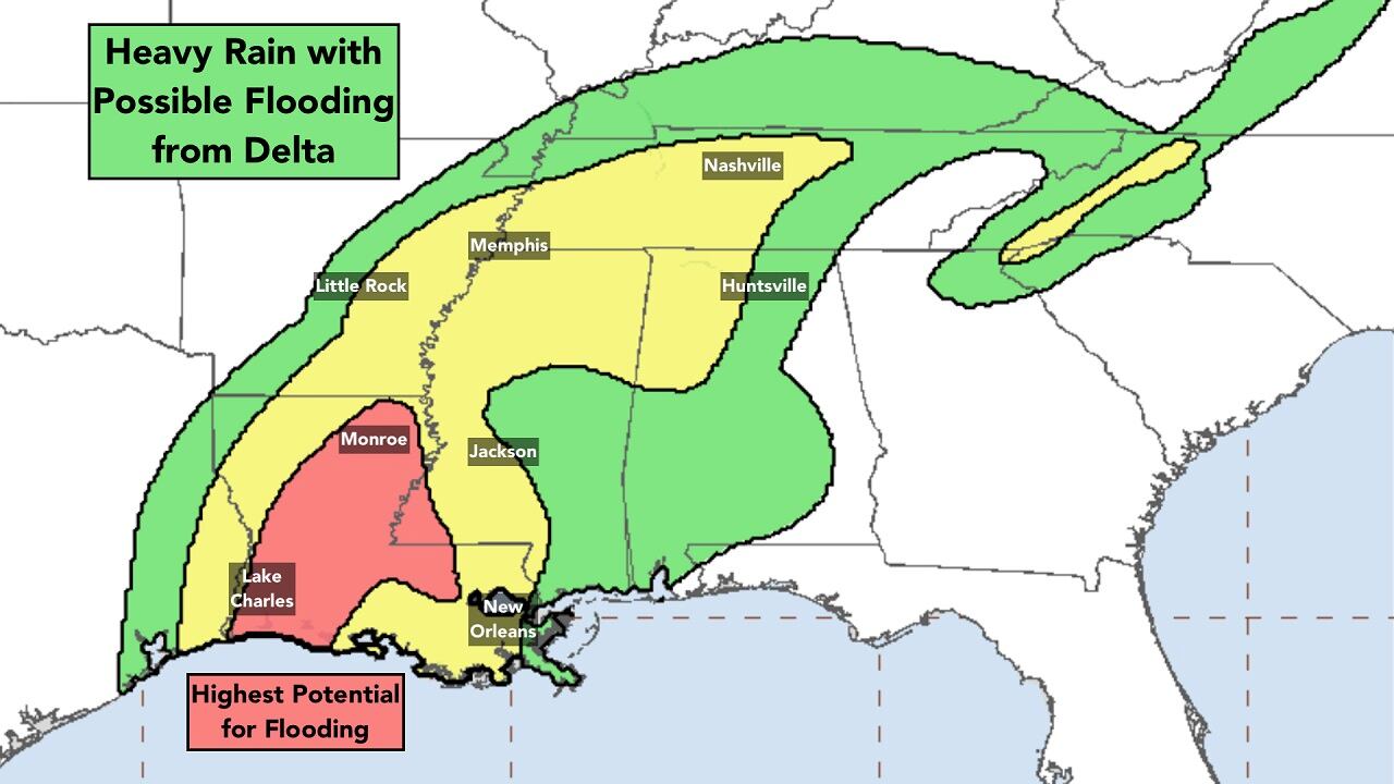
Once the hurricane goes inland, it will weaken rapidly, but become a dangerous flood-maker. Delta will paint the corridor from Louisiana into the Midwest with heavy rain. Then the remnants of the storm track through the Mid-Atlantic and the Northeast over the weekend and early next week.

Elsewhere in the Atlantic, there are no systems that appear to be a threat to the U.S., though the National Hurricane Center is making note of a large tropical disturbance on the other side of the Atlantic moving in the general direction of the Caribbean islands.
The disturbance will have a slight chance to organize in a few days as it strolls toward the islands, but before it gets there, a barrier of hostile upper-level winds is expected to rip it apart. If the forecast is right, that’s the last we’ll hear of the disturbance.
We still have a couple of weeks of the secondary October peak of hurricane season to go – just looking at the long-term averages. So we have to continue to watch, even though everybody is sick of it after 25 named storms. But nowhere near as sick of this hurricane season as the people in southwest Louisiana.
Copyright 2020 by WPLG Local10.com - All rights reserved.
