
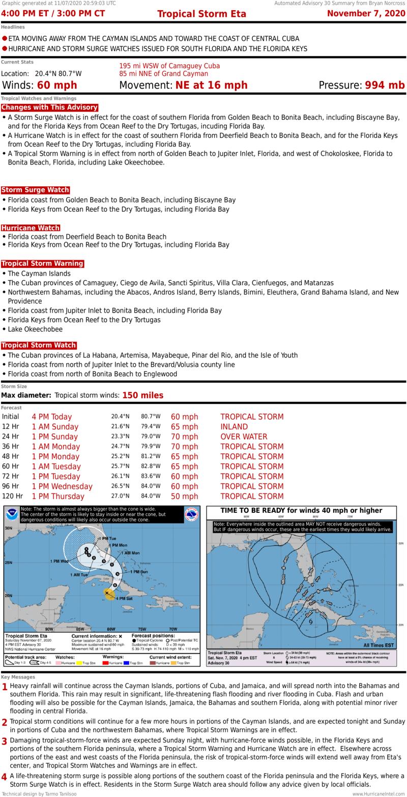
A Hurricane Watch means that winds over 75 mph are possible. As I mentioned in Saturday morning’s post, when there is a forecast for winds of 65 in a disorganized and developing storm, you plan for plus or minus 15 mph.
Now that Eta is a tropical storm, and is closer to us, we’d make the error range a little less – say, 10 or 15 mph. Since the official National Hurricane Center forecast is for Eta’s top wind to peak at 70 mph, obviously winds over 75 mph are possible, they issued a Hurricane Watch.
There is a perception difference, of course, if Eta makes it to hurricane strength. But 5 or 10 mph is not really noticeable. The structure of the storm is still expected to be as I discussed this morning. It will not be symmetrical. The worst weather will be on the north and east side of the center.
The Saturday rain is actually related to the old front that came through early in the week. It’s being pushed north by the same jet-stream dip that is pushing Eta.
The current schedule for Eta’s effects on South Florida are as follows: Bands of rain related to the front will continue to move north. There will likely be a bit of a gap, and then bands of rain associated with Eta move in early tomorrow, through tomorrow night and into Monday morning, at least. Winds will increase through the day tomorrow as the tropical downpours become increasingly gusty. It appears now that the peak winds will occur late in the day tomorrow into the overnight tomorrow night/early Monday morning.
Flooding from heavy rain is a significant threat because the bands of gusty squalls will rotate off the ocean, and may cover the same areas for an extended period of time. The National Weather Service has issued a Flood Watch for all of South Florida. They are forecasting 6 to 12 inches of rain, with higher amounts in isolated areas.
The National Hurricane Center is forecasting tides to run up to 2 to 4 feet above normal, which will flood low-lying areas. Be careful where you park your car if your neighborhood floods in King Tides.
There is also the threat of power outages. When the wind gusts over 40 mph, tree limbs can affect power lines. Be ready with flashlights, and keep everything charged up just in case.
Here is a slightly edited version of Saturday morning’s post with the details of the atmospheric pattern, the steering, etc.
Eta is being pushed north by a sharp dip in the jet stream over the Gulf of Mexico. This diving and scooping jet stream will have multiple effects on the future of Eta.
Besides lifting Eta to the north, the dip is pushing the thunderstorms upwind from the center. It is also temporarily making the atmosphere over the storm’s path conducive for strengthening. In essence, the jet-stream dip is lifting the air, helping the thunderstorms grow, which helps strengthen the circulation. This is why Eta strengthened into a tropical storm today.
But as time goes on, the strong winds associated with the dip will drive dry air into Eta’s circulation and further tilt the storm to the north. Both of these effects should have a negative influence on Eta’s strength.
All of this means that the Eta’s top winds are unlikely to suddenly increase – although we do have to recognize that a forecast a couple days ahead has an average error of about 15 mph. It also means that the bad weather will be north of the center, which means the forecast cone is not relevant to where the strongest winds and heaviest rain will be.
If the center tracks over the Upper Keys, for example, as shown in the cone, the strongest band of rain and wind could be over Dade, Broward, or farther north. And there will be multiple bands of gusty squalls with winds of 50 mph, and more in isolated cases.
The spreading out of Eta’s winds and rain toward the north will coincide with the storm merging with the upper-level system related to the jet-stream dip. Eta’s structure will become more like a nor’easter – shaped like a comma.
As a result of Eta’s forecast increase in size, the National Hurricane Center issued tropical storm alerts for the possibility of winds over 40 mph over the entire southern half of the Florida Peninsula and the Keys. The Bahamian government issued alerts for the Northwest Bahamas as well.
As Eta’s center comes closer to the Keys and southeast Florida late on Sunday and early Monday, the gustiness of the wind and the intensity of the rain will increase and spread to the north. The rain won’t be continuously heavy, but under one of the bands rotating in off the ocean, a lot of rain could fall since the bands won’t be moving very fast. This is expected to last into Monday.
The peak effects from Eta are currently expected late Sunday or early Monday. Again, the strongest winds and heaviest rain are likely to be displaced well to the north of the storm’s center shown on the cone graphic.
The National Weather Service has issued a Flood Watch for South Florida. Total rain amounts of 8 to 12 inches are forecast. The problem is, the ground is saturated from the excess rain we’ve had this year.
Since most of the bad weather will be north and east of the center, if the center passes over the Keys, those islands to the left of the track would likely get much less rain and wind.
Eta may transition from being called a tropical storm to a subtropical storm. So don’t be surprised if you see that designation. It just means that the strongest winds are not around the center, but are displaced to the north, in this case.
This entanglement of Eta and the upper-level jet-stream dip will cause the system to move slowly early in the week when it is in the vicinity of southwest Florida, which means we might have an extended period of the bad weather. Since the expected track keeps much of the Florida peninsula on the north or east side of the storm for at least a few days – where the tropical moisture feed is – the rain and gusty winds may hang around into Tuesday or Wednesday, depending on the eventual track of the center of Eta.
It is also possible that enough dry air will get wrapped into Eta’s circulation that things improve dramatically on Monday. It’s impossible to know for sure how that’s going to play out.
Be aware of where your car is parked – avoid putting in under a big tree. Have flashlights on standby, and be sure everything is charged up in case the power goes out in the gusty winds. Secure the pool furniture, or anything that might blow around outside or on your balcony.
Otherwise, just use common sense. Stay off the road in the heavy rain and beware of local flooding.
And by the way, there’s another area out in the middle of the Atlantic that might become the 29th storm of the year. It will not be a threat to the U.S.
Copyright 2020 by WPLG Local10.com - All rights reserved.
