
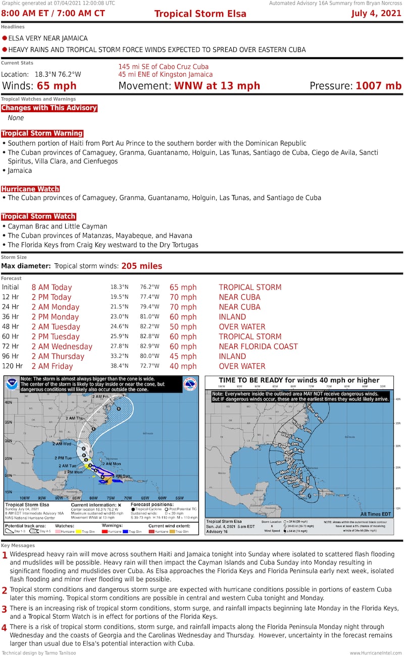
We have some conflicting information about Tropical Storm Elsa this morning.
The track of the storm has made a jog because the center reformed behind where it was. Sometimes that’s bad news because it’s a way the system can get better organized and intensify. But in this case, the slightly revised track has taken it closer to Jamaica, which means the circulation is being disrupted by the mountains on that island. The medium-high terrain of eastern Cuba also appears to be ahead of it.
Hurricane Hunters in the storm this morning are finding a generally weaker storm, at least for now. As I said, the information is conflicting.
Tropical Storm Elsa’s small vortex managed to shoot the gap between Haiti and Jamaica. Meanwhile, the upper part of the storm became disconnected from the circulation at the surface of the ocean. This is the part we track when we locate the storm on a map.
When a tropical system is not vertically aligned, the air doesn’t efficiently rise, and the system can’t strengthen much. And if the upper and lower circulations stay separated, the system usually weakens, and sometimes comes apart.
The lower part of Elsa was flying along as fast as any storm we know about, and the upper part couldn’t keep up, which weakened the system to tropical storm strength yesterday. Now the overall system has slowed down dramatically, which was expected. But the new surface circulation forming underneath the upper part was not. It’s one of those random developments that are unforecastable.
In any case, after interacting with Jamaica, Elsa will track over later Cuba today. A small or disorganized circulation is more likely to be disrupted by a trek overland, especially if mountains are involved. Exactly to what degree the disruption by Jamaica this morning and the interaction with Cuba today and tonight will weaken the storm is unknowable.
There is a space with very warm water between Jamaica and Cuba, which would give Elsa an opportunity to organize a bit, if the effect of the Jamaican mountains hasn’t disrupted the circulation too much.
The result of these positive and negative factors is that we have to be ready for a fairly healthy tropical storm to track near or over the Keys tomorrow. We shouldn’t be surprised, however, if the system has weakened significantly.
The computer forecast models are not helping. They almost universally weaken Elsa over Cuba, so their information is not really valid if the system can stay organized enough to recover when it gets to the Florida Straits or the Gulf of Mexico.
In any case, no matter the strength of the storm, the strongest winds and the heaviest squalls will be to the east of the center’s track where the air is squeezed between the Elsa’s low pressure and the strong high-pressure system over the Atlantic.
Tropical Storm Watches are up for the Lower and Middle Keys with the idea that the center is most likely to track near or to the west of Key West, putting the lower part of the Keys in the band of gustiest weather. But the area covered by watches or warnings could still be adjusted with future forecasts.
The Upper Keys and the rest of southeast Florida may still experience periods of rain with gusty downpours, but it will more likely be fringe effects, based on what we know now.
Bear in mind that forecasts for disorganized storms are on average poorer than for strong hurricanes, so Elsa’s interaction with Cuba could still surprise us – for better or for worse.
So in spite of the July 4th holiday, be careful on boats or in areas exposed to a south wind in the Lower and Middle Keys. On the current schedule, the wind will pick up late tomorrow (Monday), peak at night, and decrease later in the morning – plus or minus.
Miami-Dade and Broward will likely just get fringe effects, but some gusty downpours are still possible, depending on where the outer bands set up.
People have asked me about shutters. My rule is to NOT shutter for a tropical storm. People get hurt putting up shutters, so for me, it’s not worth that risk when a tropical storm should not threaten any structure. Of course, it’s still possible that a tree limb could hit a window, so you have to weigh that risk for yourself.
Boaters and people in structures or vehicles vulnerable to gusty winds, of course, have to take appropriate precautions.
Elsa isn’t scheduled to emerge from its trip over Cuba until tomorrow afternoon, so we’ll have to wait until then to see how organized the circulation is that moves over the Florida Straits. Generally, we feel good, however, that this won’t be an extreme storm for the Keys.
The bigger question would seem to be about the west coast of Florida. If Elsa swings wide enough in the Gulf, it might have time to reorganize before it turns into the west coast near Tampa Bay plus or minus.
The west coast from Naples to Tampa Bay is extremely vulnerable to storm surge when strong winds blow onshore, so Elsa doesn’t have to become a super-strong hurricane to cause significant problems in low-lying coastal sections. Heed the warnings issued by the National Hurricane Center and alerts from local officials.
Stay aware and be safe.
Prepare for hurricane season
Copyright 2021 by WPLG Local10.com - All rights reserved.
