
The National Hurricane Center is highlighting three areas for potential development. The one of most immediate concern is Tropical Disturbance #1, which long-range computer forecast models indicate may eventually end up in the western Gulf.
Tropical Disturbance #1 is barely trackable at this point. But in a few days, a broad low-pressure system that spans Panama from the southern Caribbean to the Pacific Ocean is forecast to merge with the weak disturbance moving west near the South American coast. If the models are right, an area of low pressure will develop on the Caribbean side of the merged system. That process could start later today or, more likely, tomorrow.
Separately, a large upper-level low-pressure system east of the Bahamas will drift over Florida around Thursday. That will increase the chance of thunderstorms for South Florida, and change the steering flow over the Gulf and Caribbean. As a result, the disturbance should start to move northwest toward Mexico’s Yucatán peninsula and the southwestern Gulf.
It appears that the same areas in Mexico that were just hit by Hurricane Grace may be affected by this disturbance. But based on what we know now, this one won’t be as strong.

The big question is, what’s going to happen around the weekend? The forecast weather pattern over the western Gulf early next week appears to be supportive of development, if the center of the system stays over the water. Everybody on the Mexico and Texas coast should stay informed about developments with the disturbance.
Tropical Disturbance #2 has a decent chance of forming into at least a tropical depression in the middle of the Atlantic. All indications are that it would move out to sea.
Tropical Disturbance #3 is forecast to track across the tropical Atlantic for the next several days. There is no indication of any threat to land at the current time.
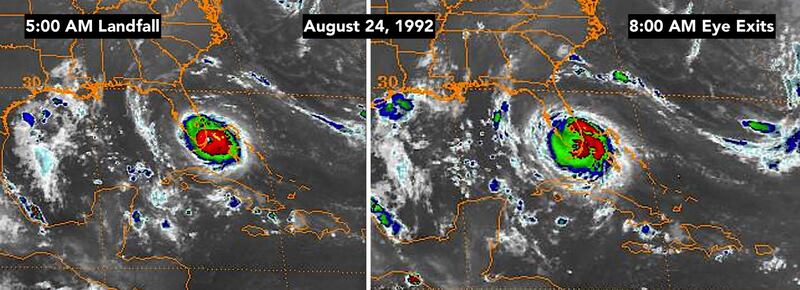
Twenty-nine years ago this morning, the world in South Dade turned upside down. As Miami was breathing a sigh of relief that the city had survived the 3 ½ hour assault from Hurricane Andrew, I said on TV that it was not good news that we hadn’t heard from Cutler Ridge and Homestead. I feared the worst… and it was worse than that.
The center of the eye of Hurricane Andrew made landfall at 5 a.m. at Fender Point – a spit of land that sticks into Biscayne Bay just east of what was then Homestead Air Force Base. By 8 a.m., the eye was over the Everglades, and the winds had died down enough that people in South Dade could come out of hiding to see what was left of their homes, their neighborhoods and their lives.
The satellite images from that morning show how small Andrew was. Its fierce power was packed into a compact circulation that was like a big tornado with wind gusts over 200 mph.
Nobody had seen anything like it since 1935. Even the powerful winds of Hurricane Camille in 1969 didn’t do this kind of damage.
Freaky things happened. Wood split palm trees. Bark peeled off trees. Cars flipped inside garages. Windows broke inside shutters from the extreme pressure of the wind.
Hurricane Andrew taught us many things. But the most important lesson of 1992 is something we should remember for this hurricane season and all to come. Andrew first became a hurricane just 48 hours before it hit as an over-the-top Category 5.
We won’t always have a week to watch and prepare. Hurricane plans have to build in that reality.
Stay aware. Stay informed. Be prepared.
Copyright 2021 by WPLG Local10.com - All rights reserved.
