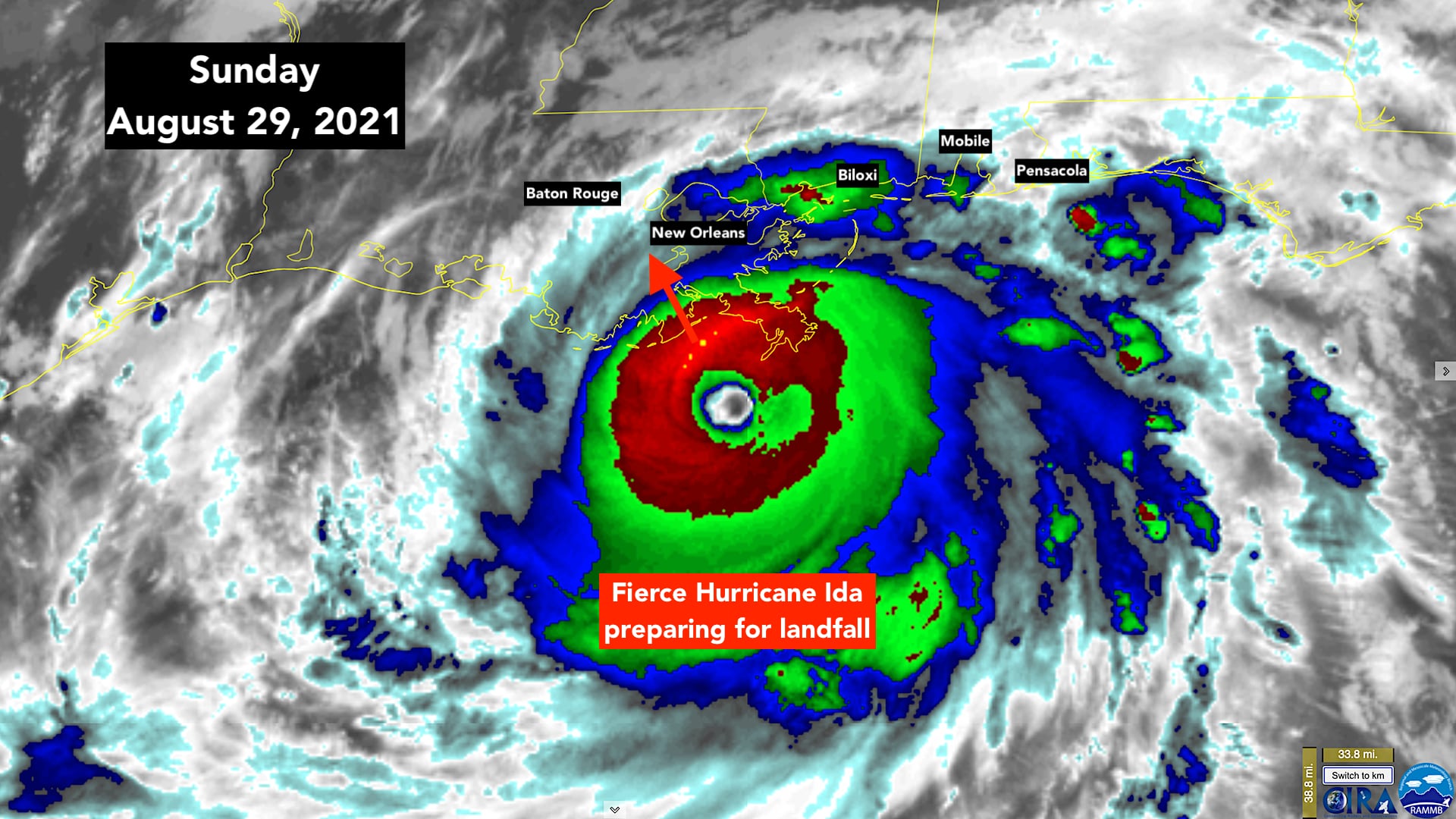
Hurricane Ida is a high-end Category 4. The National Hurricane Center is noting that it could reach Category 5 over the very warm water near the Louisiana coast before landfall.
As feared, the storm has grown in size and intensified dramatically. In a matter of hours, it will make landfall on the south coast of Louisiana. Damage will be widespread along the Gulf coast across Mississippi into Alabama, and inland to the population centers of Baton Rouge and New Orleans.
WIND: Ida will likely be as strong or stronger than any known hurricane that ever hit Louisiana. In most of those historic storms, the worst of the winds missed New Orleans. This will be a close call. The city will not get the maximum winds like at the coast, it’s far enough inland. But extreme, damaging winds will blast through the metro area later today. It will be nothing like anything anybody there has ever seen.
This is not a huge storm like Katrina. In Ida, the intense hurricane winds will be in a band within about 75 miles to the right of where the center tracks, which includes metro New Orleans. It appears Baton Rouge will be hit head-on. Winds gusting to 40 mph extend some 250 miles off to the east, which includes part of the Florida Panhandle.
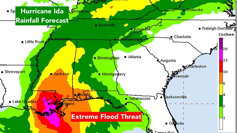
RAIN: The heavy rain will spread far from the center and inland ahead of the storm. Totals of around a foot to two feet are forecast, so major flooding from rainfall will be extreme near the coast and far inland as well.
STORM SURGE: The northern Gulf Coast, with its big, shallow shelf and myriad inlets, bayous, and bays, is very vulnerable to storm surge. Life-threatening water rise will extend well away from the core of the storm and well inland. We can only hope that everybody moved out of the low-lying areas and found high ground.
The giant New Orleans levee and flood-wall system should keep the metro safe from storm surge. Ida’s angle of approach should save them. But flooding from heavy rain, trees down on houses and cars, and power outages will still likely be very widespread.
Outside the so-called Hurricane and Storm Damage Risk Reduction System protecting New Orleans, many areas are in maximum danger from the surge. If the Gulf water rises as forecast by the National Hurricane Center, some or many local levees will be topped flooding towns and neighborhoods.
Hopefully, people are in place, as well equipped as they can be, and ready.
The Key Messages from the National Hurricane Center are:
1. There is a danger of life-threatening storm surge inundation Sunday along the coasts of Louisiana, Mississippi, and Alabama within the Storm Surge Warning area. Extremely life-threatening inundation of 9 feet or greater above ground level is possible somewhere within the area from Morgan City, Louisiana, to the coast of Mississippi. Overtopping of local levees outside of the Hurricane and Storm Damage Risk Reduction System is possible where local
inundation values may be higher. Interests throughout the warning area should follow any advice given by local officials.
2. Ida is expected to be an extremely dangerous major hurricane when it reaches the coast of southeastern Louisiana. Hurricane-force winds are expected Sunday in portions of the Hurricane Warning area along the Louisiana coast, including metropolitan New Orleans, with potentially catastrophic wind damage possible where the core of Ida moves onshore. Actions to protect life and property should be rushed to completion in the warning area.
3. Damaging winds, especially in gusts, will spread inland near the track of the center of Ida across portions of southeastern Louisiana and southwestern Mississippi Sunday night and early Monday. These winds will likely lead to widespread tree damage and power outages.
4. Ida will produce heavy rainfall today through Monday across the central Gulf Coast from southeastern Louisiana, coastal Mississippi, to far southwestern Alabama resulting in considerable to life-threatening flash and urban flooding and significant riverine flooding impacts. As Ida moves inland, significant flooding impacts are possible across portions of the Lower Mississippi, Tennessee, and Ohio Valleys through Wednesday.

Out in the Atlantic, there are two tropical depressions: Ten and Eleven. Both might become tropical storms before they die out over the ocean without threatening land.
And over Africa, there’s a robust disturbance that has a good chance of developing after it gets over the ocean water. This one might get quite strong, but it’s likely to stay well away from land as well.
Currently, there is a big break in the blocking high-pressure system that is usually sprawled across the Atlantic. So, for now, systems out in the Atlantic are turning north well before they become a threat.
Off the Virginia coast, Disturbance #1 is drifting away from land. It has a slight chance to develop into at least a tropical depression.
Copyright 2021 by WPLG Local10.com - All rights reserved.
