The National Hurricane Center designates Sept. 10 as the official peak of hurricane season – the day when we are most likely to have a named storm. Today’s date is based on a rolling average of 100 years of storm – plus or minus.

Brian McNoldy at the University of Miami recently analyzed the data. In actual fact, depending on what time period you chose, you get a bunch of dates but all within a week or so of today’s. So Sept. 10th is as good as any other to commemorate it.
According to calculations by Dr. Phil Klotzbach at Colorado State, in South Florida, the date comes later, however. A hurricane is more likely in October than in September, although a strong hurricane – Category 3 or higher – is more likely in September.

Appropriate to the day, the tropics are fairly busy.
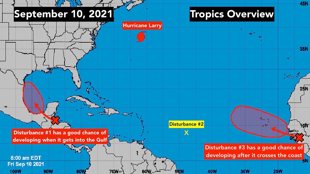
Diffuse Tropical Disturbance #1 is around and over Mexico’s Yucatán peninsula. When it moves over the warm water of the southern Gulf of Mexico over the weekend or early next week, it has a fair chance of developing into at least a tropical depression.
Whether it develops or not, it will be carrying a ton of tropical moisture, so wherever it impacts, there will be a threat of very heavy rain. The mainland Mexico and Texas coasts will have to watch the system to see how it develops.
As always, forecasts for systems that haven’t yet developed are iffy and always subject to change. The computer forecast models currently predict a circulation will develop Sunday, so forecasts should improve after that time.
Giant Hurricane Larry is speeding north to an encounter with Newfoundland in far eastern Atlantic Canada tonight. It’s forecast to hit there as a Category 1.

The system is huge so it’s continuing to generate extra-powerful swells that are spreading across the entire Atlantic. Least affected on the U.S. East Coast are Broward and Miami-Dade counties because the Bahamas shields extreme South Florida from the full impact of the energy in the ocean.
Hurricane Olaf is impacting the Baja California peninsula near Cabo San Lucas as a Category 1 storm. It should start to move out to sea today.
Tropical Disturbance #2 is fairly energetic, but it’s encased in lots of dry air. No development is expected over the next several days. When it gets closer to the United States in about a week, however, we’ll watch it as at least a moisture surge.
Disturbance #3 is still over Africa, but it’s robust enough that the National Hurricane Center is giving it a high chance of developing into at least a tropical depression pretty quickly when it reaches the Atlantic waters.
A lot of dry air continues to cover the eastern Atlantic, so the disturbances over that part of the ocean will have to contend with that, which often slows or stops their development.
If either Disturbance #1 or #3 develops winds of 40 mph or higher, it will be named Tropical Storm Nicholas.
Copyright 2021 by WPLG Local10.com - All rights reserved.
