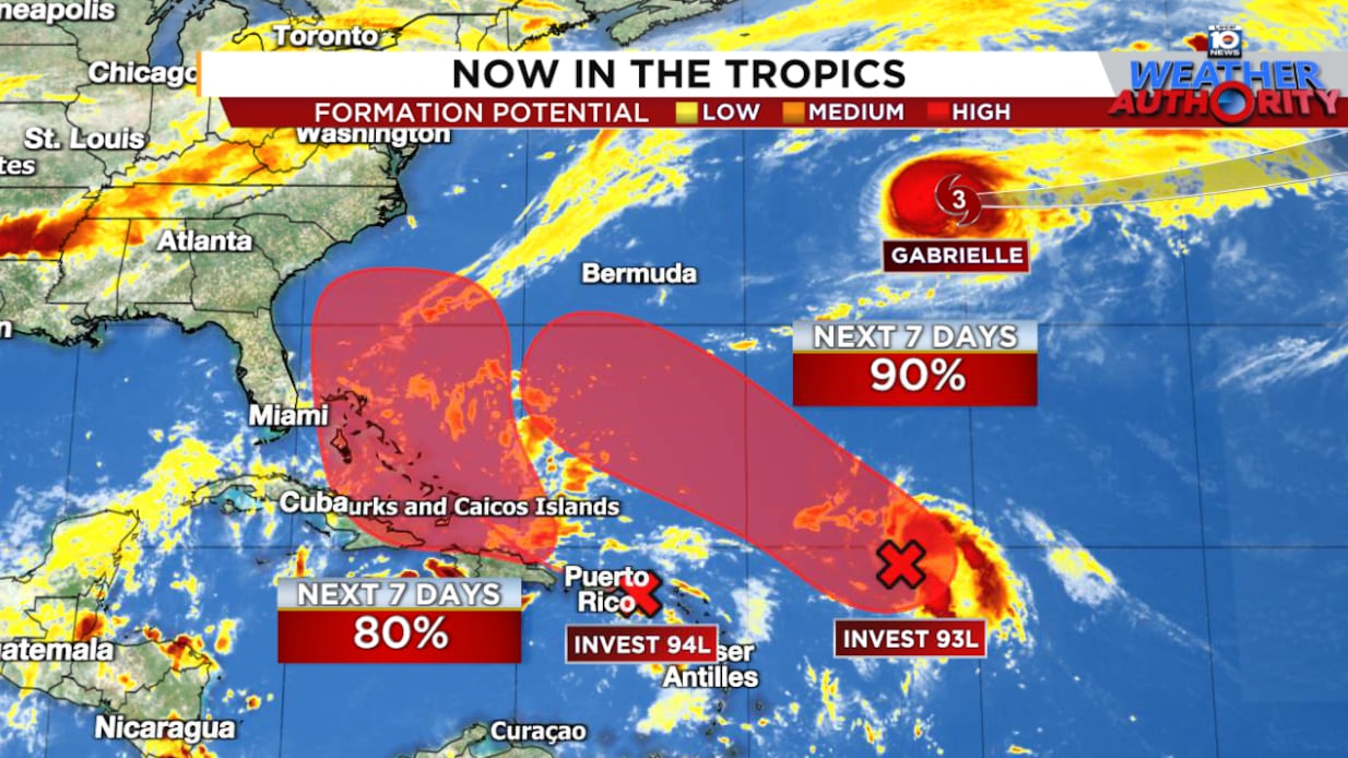
Two vigorous tropical disturbances – designated Invest 93L (easternmost disturbance) and Invest 94L (westernmost disturbance) – are likely to develop in the coming days and could bring impacts to land, with the westernmost system tracking through the Bahamas and near Florida, Georgia, and the Carolinas for early next week.

Of the two disturbances, the easternmost system (Invest 93L) appears poised to develop first over the open waters of the central Atlantic, perhaps as soon as today.
Meanwhile, the westernmost system (Invest 94L), about 700-800 miles to the west of 93L, remains disorganized as it passes through the northern islands of the Caribbean. Hostile wind shear is forecast to subside by Friday into the weekend as 94L nears the warm water of the Bahamas, however, which should allow it to organize.
Awaiting the crucial turn
Both systems will head generally west until the weekend, when they’ll bend northward around the western side of subtropical high-pressure steering.


The forecast is complicated by how close the two systems get to one another this weekend and early next week, which could influence not only their organization, but their paths.
They should be in the distance range where a binary interaction – a phenomenon called the Fujiwhara effect – could take place. The Fujiwhara effect is uncommon in the Atlantic but can occasionally happen. In this binary interaction, the two circulations get entangled with one another, rotating around a common pivot point, but more often than not one circulation becomes dominant and weakens its nearby neighbor.
For now, most forecast models keep the two systems distinct entities into early next week, and a true Fujiwhara interaction remains an outlier scenario. Nevertheless, even a low possibility of a binary interaction complicates the outlook.
Which becomes the stronger system?
Forecast models are divided on which area becomes the stronger, dominant system early next week, likely due to a complicated upper-level pattern.
The European model advertises both systems becoming hurricanes by next Monday.

The American GFS keeps 94L – the westernmost system – weak, with 93L becoming a hurricane and gobbling up 94L’s circulation. Google’s DeepMind AI hurricane model is similar to the European solution, showing the possibility of two distinct hurricanes early next week.

The next names on the list are Humberto and Imelda.
The dueling hurricane scenario is supported by our most reliable intensity aids, including the corrected consensus aids and our next-generation hurricane models like the Hurricane Analysis and Forecast System (HAFS or HFAI and HFBI below).


Monitoring heavy rain potential for the Carolinas and Mid-Atlantic early next week regardless
Even if 94L stays weak and offshore next week, the upper-level pattern with a cutoff low pinching off over the Tennessee Valley could funnel abundant tropical-laden air into the Carolinas and parts of the southern and central Appalachians and Mid-Atlantic for the start of next week.
This suggests an enhanced flood threat for these areas beginning this weekend, which we’ll need to follow over the coming days.
Hurricane Warning for the Azores
Although Gabrielle is weakening over the north Atlantic, its fast forward speed and interaction with the jet stream will give its winds a boost as it rips through the Azores late Thursday and Friday.

A hurricane warning is in effect for all of islands of the Azores, the first time a hurricane warning has been issued for the Portuguese archipelago in 6 years (since Lorenzo in late September 2019).
Copyright 2025 by WPLG Local10.com - All rights reserved.

