
NOAA Hurricane Hunters investigating Tropical Depression Two Monday evening, centered about 120 miles south of Panama City Beach, Florida, in the northeastern Gulf, found winds of 40 mph – the threshold for tropical storm strength – supporting its upgrade to Tropical Storm Bertha, the second named storm of the 2026 Atlantic hurricane season.

On average over the past 30 years, the second named storm has formed on July 17 in the Atlantic basin.
Bertha’s disheveled appearance a sign of its struggles
Hurricane Hunters flying Bertha Tuesday morning found pressures down slightly from earlier missions with thunderstorms trying to build near or over to its earlier exposed center, which could give the storm a brief window to organize further today. That said, wind shear is high and is forecast to only strengthen in the days ahead, which should mean any strengthening will be short-lived and limited.
The strong upper-level winds from the north responsible for the high wind shear will also keep the storm lopsided, with a relatively dry north side and the heaviest rainfall and worst weather to the south of the center.
Heaviest rainfall to remain well offshore
The lopsided nature of Bertha means its highest rainfall totals exceeding a foot will remain well offshore and widespread flooding isn’t expected as it skirts westward along the northern Gulf Coast this week.
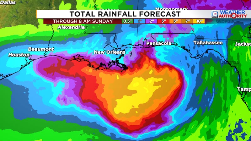
Locally heavy rain is possible in outer bands near and north of the center, however, and some parts of the Florida Panhandle, coastal Alabama, and southern Mississippi and Louisiana could see localized flooding through Thursday.

Bertha not so big and full of bluster
Overall, the threat Bertha poses to the coast is low. The storm is likely peaking or will peak today as a mid-tier tropical storm (highest winds in the 50-60 mph range; hurricane winds start at 74 mph) and weakening should commence in earnest by tomorrow.
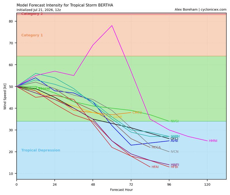
Although Tropical Storm Warnings are posted from extreme southeastern Louisiana to the Alabama/Florida border for the likelihood of tropical storm conditions, Bertha doesn’t pose a widespread damaging wind threat and sustained tropical storm winds (winds of 40 mph or higher) should be contained mostly to rain squalls and periodic gusts over the next few days.
High surf along the north Florida and Alabama shoreline will lead to treacherous beach conditions and life-threatening rip currents. If you’re on a beach vacation in these areas, this is a week you’ll want to stay out of the water.
Deafening crickets across the Atlantic
Elsewhere, the Atlantic appears closed for business for the rest of the month. As we’ve discussed in previous newsletters, we’ll keep an eye to the subtropics this season (like the zone in the Gulf where Bertha formed), but for now, we’re not seeing any candidates for at least the next few weeks.
Copyright 2026 by WPLG Local10.com - All rights reserved.
