
60+ people evacuated from Hollywood hotel after fire, 2 hospitalized
A fire was reported early Friday morning at a two-story hotel in Hollywood, first responders confirmed to Local 10 News.
60+ people evacuated from Hollywood hotel after fire, 2 hospitalized
A fire was reported early Friday morning at a two-story hotel in Hollywood, first responders confirmed to Local 10 News.

A magnitude 5.8 earthquake struck off the coast of eastern Cuba early Tuesday, according to the U.S. Geological Survey.

The Miami Open canceled Sunday’s qualifying matches and practices due to inclement weather in Miami Gardens.

A stationary front over South Florida separates cooler, drier air to the north from warmer, more humid air here.

Local 10 Hurricane Specialist and Storm Surge Expert Michael Lowry and his wife, Kait, have welcomed their third child.

A beige haze hung over Alligator Alley near mile marker 75 as thick smoke from a wildfire in Big Cypress Preserve pushed across the sky.

A massive brush fire in Collier County’s Big Cypress National Preserve is causing smoky conditions on Alligator Alley, affecting visibility and travel.

A severe snowstorm in the Northeast caused near-hurricane-force winds, power outages and whiteout conditions ― and flight cancellations and delays rippling down to South Florida.

Crews are preparing for potential brush fires in the next few days as dry conditions and strong winds create favorable conditions for fires to spread.

Lows this morning are in the 50s, with wind-chill temperatures in the 40s.

Hundreds of flights were canceled on Monday in South Florida, as a cold front hit several states in the U.S.

As several major Northeast cities brace for a potentially historic snowstorm, travelers are trying to get out ahead of the weather -- including some at Miami International Airport.

Local 10 News Weather Authority meteorologists forecast a dry Valentine’s Day with comfortable temperatures for the South Florida romantics who like the outdoors.

The South Florida Water Management District, the government agency that manages water resources in 16 counties, met on Thursday in West Palm Beach.

Hazy and foggy conditions are expected across parts of South Florida on Thursday as a brush fire in northwestern Broward County combines with shifting winds to reduce visibility in some areas.
When temperatures dropped so low in Florida that cold-stunned green iguanas were falling from trees, state animal regulators moved quickly.

Tuesday morning marked another chilly start to the day, but temperatures will be rising in the afternoon.

South Florida only hit the 50s for highs on Monday and cities across the state, including Fort Lauderdale, set record lows.

Many visitors expecting to get South Florida’s warm sunshine instead had to don heavy jackets as the area experienced a cold snap.

Farmers in southern Miami-Dade County’s Homestead area reported on Monday that the Florida freeze had damaged some crops.
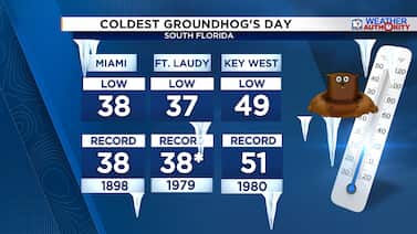
Every Feb. 2, Punxsutawney Phil emerges to predict whether winter will stick around or spring will arrive early.

Students across South Florida braved the cold weather Monday as they headed back to school with temperatures dipping back into the 30s.

With the rare artic cold front in full effect in South Florida, it’s another night of bundling up to keep warm.

As temperatures dropped across South Florida, staff at Flamingo Gardens shifted into cold-weather mode to keep their animals warm.

South Florida was in the midst of its deepest cold snap in more than a decade on Sunday morning, with temperatures in the mid-30s and wind chills in the mid-20s.

Ahead of the cold snap, volunteers with The Homeless Voice rolled up to the downtown Fort Lauderdale bus station with an ambulance packed full of supplies, ready to help people living on the streets.

With a cold snap hitting South Florida, this plant nursery owner is doing everything he can to protect his tropical plants.

South Florida nurseries are rushing to protect their plants as a rare cold snap threatens temperatures not seen since 2010, when significant cold damage devastated inventory across the region.

The powerful Arctic cold front crossed into South Florida early Saturday afternoon, bringing in wind gusts around 40 mph.

An arctic cold front is crossing South Florida on Saturday, bringing rain, gusty winds and a sharp drop in temperatures, with a cold weather advisory in effect for much of the region and freeze warnings posted for inland areas.

We don’t talk about it often in South Florida, but this week, the wind chill number has become the most important part of the forecast.
South Florida is bracing for an unusual cold snap this weekend, and locals and tourists alike are preparing for temperatures far below the region’s typical warmth.

Camillus House activated its emergency housing for people experiencing homelessness Friday in downtown Miami ahead of the weekend’s cold snap.

Cloudy skies and scattered showers are expected Friday as a weak disturbance moves across South Florida, with the best chance for rain across the Florida Keys and East Coast metros.

South Florida is about to feel more like the Midwest this weekend, and Local 10 News wants to see how you’re experiencing the chill.

South Florida is bracing for an unusually cold weekend as Arctic air sweeps into the region, leaving locals bundling up and farmers racing to protect crops.

Cold air that has been building in the Arctic Circle earlier this week is crossing into the U.S. from Canada
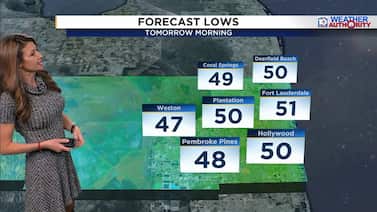
Now that the cold front has cleared, we are waking up to a chilly change with lows in the 50s and wind chill temperatures in the 40s.

Bundle up, South Florida! Temperatures are forecast to drop significantly on Monday night as a cold front moves into the area.

The wave of cancellations continued Monday at Miami International Airport as a monster winter storm moving across the country caused chaos at many of the nation’s airports.

Flight delays and cancellations are affecting travelers in South Florida who are heading anywhere on the East Coast this weekend, where winter weather warnings are taking effect.

A sudden cool snap in South Florida has residents debating whether they prefer the region’s signature heat or a brief taste of colder weather.

A Cold Weather Advisory has been lifted for inland Broward and Miami-Dade after the coldest air to hit South Florida in nearly four years arrived.

A strong cold front is moving through South Florida, bringing the coldest air the region has experienced in nearly four years.

Happy New Year’s Eve! It’s a chilly start on Wednesday morning, with temperatures in the 40s.
A cold front is sliding past our area on Tuesday, and behind it, noticeably cooler and much drier air will settle into South Florida.
After all the running around this holiday season, we get a chance to decompress with fantastic weather this weekend!

The Carnival Horizon, a massive cruise ship, set sail this week on a mission to deliver 24 pallets of much-needed medical supplies to Jamaica.

A cold front is forecast to lower temperatures to about 68 degrees on Tuesday in South Florida.

Winter weather continues to hamper travelers returning from Thanksgiving destinations, as a new storm system forms in the Mid-South.

The first season in a decade without a U.S. hurricane landfall also featured three Category 5 hurricanes, including Melissa, one of the strongest Atlantic hurricanes on record.

Winter Storm Bellamy was forecast to disrupt post-Thanksgiving travel on Saturday and Sunday.

If you’ve seen glowing streaks of green, pink, or purple dancing across the sky lately, that’s not just nature showing off — that’s the sun sending energy our way.

Lows are in the 50s Tuesday morning with wind chill temperatures in the low 50s and upper 40s.

Tens of thousands of pounds of food, water and medical supplies from South Florida arrived in Kingston, Jamaica on Monday, part of a relief effort to support communities devastated by Hurricane Melissa.

A strong cold front is expected to clear South Florida Monday afternoon, leading to a chilly change.

Days after Hurricane Melissa tore through Jamaica, aid groups are still struggling to reach some of the island’s hardest hit areas, including Trelawny Parish, where damage to roads and infrastructure continues to slow relief efforts.

Jamaica’s Trelawny Parish, east of Montego Bay, is one of the island’s hardest hit but least assessed areas.

Melissa’s 10-day run as a tropical cyclone – culminating in a catastrophic Category 5 strike on western Jamaica Tuesday – will end Friday as it transitions into a powerful non-tropical storm, clipping Atlantic Canada’s southern Avalon Peninsula tonight before heading swiftly out to sea.

Planes packed with food, water, and emergency supplies are taking off from Miami to help storm-ravaged communities in Jamaica.

After weakening to a Category 1 hurricane after its passage across the rugged terrain of eastern Cuba, by Wednesday afternoon Melissa was recovering over the waters around the speckled islands of the southeastern Bahamas.

Hurricane Melissa slammed into eastern Cuba on Wednesday, leaving behind widespread flooding, power outages and heavy damage — and sparking concern among Cuban Americans in South Florida.

Hurricane Melissa, which devastated western Jamaica as one of the strongest hurricanes ever recorded, briefly restrengthened between Jamaica and Cuba late Tuesday before making a second landfall shortly after 3 a.m. ET Wednesday as a Category 3 hurricane about 40 miles west of Santiago de Cuba – the country’s second most populous city – in eastern Cuba.

Flooding from Hurricane Melissa killed 25 people in Haiti while the storm still churned across Cuba on Wednesday after leaving Jamaica with widespread damage and power outages, officials say.

The Miami Heat, along with the Micky & Madeleine Arison Family Foundation and Carnival Corporation, announced a $1 million donation to Direct Relief to help recovery efforts in Jamaica following Hurricane Melissa.

Category 5 Hurricane Melissa set a collision course early Tuesday with Jamaica and made landfall at New Hope, Jamaica, on the island country’s southwest coast at peak strength around noontime local on Tuesday.

Local 10 News reporter Aaron Maybin is in Montego Bay, Jamaica, where Hurricane Melissa made landfall Tuesday as a catastrophic Category 5 storm.

Hurricane Melissa intensified Tuesday before making landfall in Jamaica, where officials and residents braced for catastrophic winds, flash flooding and landslides from the Category 5 storm, one of the strongest Atlantic hurricanes in history.

Hurricane Melissa put on a rare show overnight, tipping the scales as a Category 5 hurricane by the predawn hours Monday while drifting only about 100 miles south of Jamaica over the deep, warm waters of the central Caribbean.

Hurricane Melissa is now a massive Category 5 storm as it nears Jamaica, where it will bring life-threatening storm surge.

The National Weather Service said there’s a high risk of dangerous rip currents Saturday evening.

Residents and visitors across Jamaica are bracing for Tropical Storm Melissa, which is expected to strengthen into a major hurricane, bringing heavy rain, strong winds, and the threat of flooding and landslides.

Tropical Storm Melissa grounded to a halt over the central Caribbean about 150 miles south of Jamaica and Haiti early Friday.

Tropical Storm Melissa was nearly stationary in the central Caribbean early Friday, with forecasters warning it could soon strengthen and brush past Jamaica as a powerful hurricane while unleashing catastrophic flash flooding and landslides in southern Haiti.

Tropical Storm Melissa continued to struggle early Thursday as it crawled several hundred miles south of Jamaica and Haiti over the central Caribbean.

Tropical Storm Melissa formed late Tuesday morning about 300 miles south of Haiti over the central Caribbean but remains disorganized as it contends with persistent wind shear.

The strong tropical disturbance designated Invest 98L over the weekend is coming together as Tropical Storm Melissa Tuesday morning, and the National Hurricane Center expects to issue its first forecast on the Atlantic hurricane season’s 13th named storm shortly.

A tropical wave that moved into the eastern Caribbean on Sunday – designated Invest 98L by the National Hurricane Center on Saturday – is becoming increasingly organized and will likely become a tropical depression or tropical storm in the next day or two as it slows over the central Caribbean.

A strong late-season tropical wave now moving through the central Atlantic could develop once it enters the Caribbean as upper-level winds turn increasingly conducive next week.

Since the basin reopened for business about a month ago following a bizarre 20-day drought with no active tropical systems through the traditional peak of the hurricane season, it’s managed to notch 6 of its 12 named storms and a full 60% of the season’s overall tropical activity as measured by the Accumulated Cyclone Energy or ACE.

Despite earlier forecasts showing Tropical Storm Lorenzo hanging around into the weekend, the unfriendly central Atlantic of mid October has done a number on it, and it’s no longer expected to survive the work week.

Despite a lopsided and disheveled appearance, Tropical Storm Jerry’s winds have gradually ticked up and it’s expected to be just shy of hurricane strength as its center curves north of the northern Leeward Islands along the northeastern edge of the Caribbean later today.

Tropical Storm Jerry, the 10th named storm of the hurricane season, formed late Tuesday morning and is forecast to strengthen into a hurricane on Thursday or Friday as it makes its closest pass near or just north of the northern Leeward Islands.

Cruising up A1A in the Broward city of Hollywood this time of year is a slow roll through South Florida’s struggle with sea level rise and tidal flooding.

With the harvest moon comes high tides, and some parts of Broward County are really feeling the effects.

A strong tropical disturbance churning through the central Atlantic – designated Invest 95L – continues to organize and is on the cusp of becoming a tropical depression or named storm. The next name on the list is Jerry.

King tides caused a flood of trouble Monday morning in Fort Lauderdale, leaving some streets underwater.

A robust tropical wave – a ripple in east-to-west flowing trade winds at about 10,000 feet resembling an ocean wave – plodding through the central Atlantic this week is poised to develop into a tropical depression or named storm.

South Florida’s annual “King Tides” are back from early September through December.

South Florida was on weather watch on Friday as an area in the tropics brings heavy winds and high rip currents through the weekend.

The 2025 hurricane season that hit the pause button for nearly 3 weeks around its traditional peak in September is showing no signs of slowing as we enter its final stretch.

Hurricane Imelda struck Bermuda head on during the midnight hours late Wednesday and early Thursday, plunging about half the archipelago into darkness as daylight broke Thursday.

Hurricane Imelda is accelerating away from the U.S. but strengthening on a beeline to Bermuda for later today, where it’s forecast to bring strong winds to 100-plus mph, flooding rains, and powerful and destructive waves.

Imelda became the 4th hurricane of the 2025 hurricane season early Monday as it began its anticipated turn eastward only about 250 miles off Florida’s east-central coast.

Tropical Storm Imelda formed Sunday afternoon just east of the southern tip of Andros Island in the northwestern Bahamas and continues to strengthen near Great Abaco Island in the northern Bahamas – about 200 miles east of southeast Florida – on Monday.

Tropical Depression Nine was set to become Tropical Storm Imelda, and Hurricane Humberto strengthened into a Category 5. Both are tracked to turn northbound and away from South Florida.

Tropical Depression Nine formed late Saturday morning over the southeastern Bahamas and is forecast to steadily strengthen into Hurricane Imelda by early next week as it approaches the coast of South Carolina.

Humberto rapidly strengthened to a hurricane early Friday and is forecast to ramp up into a formidable major (Category 3 or stronger) hurricane this weekend, but it’s the disturbance to Humberto’s west that’s expected to develop and threaten the southeast U.S. – likely as Imelda – by late weekend and early next week.

The peak of hurricane season has arrived with two systems in the Atlantic we are closely monitoring, so make sure to rescan all of the TVs in your home if you use an antenna and download our latest apps for the latest updates.

Humberto – the 8th named storm of the hurricane season – formed Monday afternoon over the central Atlantic and is forecast to become a major (Category 3 or stronger) hurricane by Monday as it turns east of the U.S.
