
We’ve written a lot about El Niño – the abnormal warming of waters across the eastern Pacific around the equator – in this newsletter this year. With it shaping up to be one of the strongest El Niños on record, we want to cover all angles of where we could see (and are already seeing) its fingerprints this hurricane season.
We’ve looked at how El Niño condenses hurricane season activity and often shuts down the season early. We’ve written about the rapid pace of the current El Niño and how it’s having an earlier-than-usual influence on wind shear across the Caribbean, where El Niño’s influence is most noticeable during the peak months of the hurricane season. We’ve also examined how the odds of a hurricane hit change for each state in a relative sense in El Niño years like this one. We’ve even singled out the subtropics as a hotspot in seasons when El Niño comes to town.
Where might we see increased or reduced tropical activity this season?
Today we’ll analyze how strong El Niños like this one transform the typical pattern of tropical activity across the Atlantic. When we isolate only the strongest El Niño years of the modern satellite record (since around 1966), we find a stark reduction in tropical activity – as measured by the Accumulated Cyclone Energy or ACE – across most of the Gulf and Caribbean and around South Florida compared to the typical 30-year averages. This reduction in tropical activity is statistically significant and consistent with previous research that shows significantly less damage to the mainland U.S. during El Niño years.
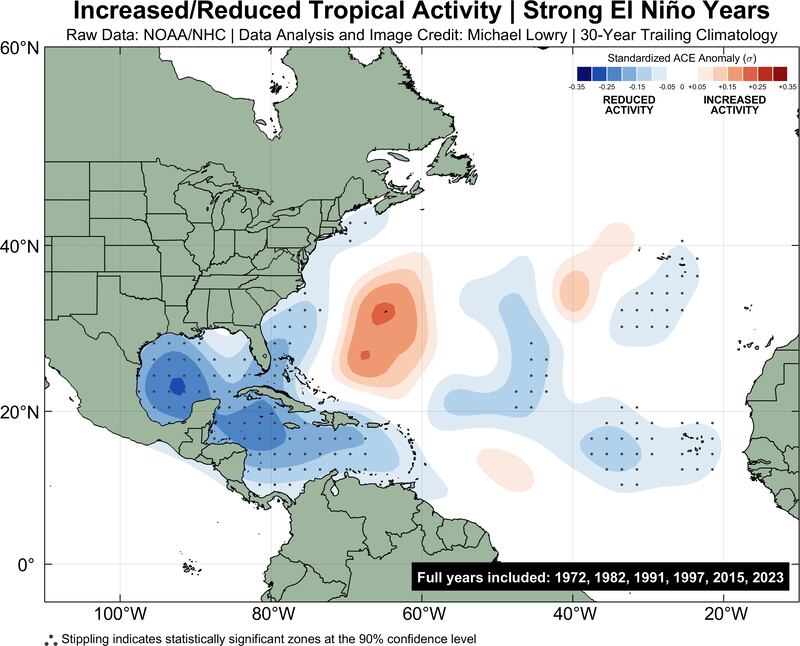
Also the increase in tropical activity east of the U.S. in the subtropics around Bermuda, though not statistically significant, is consistent with other research finding storms tend to recurve over the open Atlantic more frequently during El Niño years.
During strong La Niña years, the pattern is essentially flipped, with a statistically significant increase in tropical activity across nearly the entire belt from Africa through the Caribbean – the primary hurricane thoroughfare known as the Main Development Region or MDR – and across the Gulf. It’s no surprise that these years are often the busiest and most destructive of our hurricane seasons.

That said, the wiggles and wobbles of activity during El Niño years are smoothed out in these analyses to show the overall effect of El Niño or La Niña on the season. Hurricanes – even big, strong hurricanes – can still happen during strong El Niños and nothing in these analyses suggests one can’t hit this year. What this does tell us is the strike risk is reduced to the U.S. this season and we should expect overall fewer storms closer to home than what we might expect in a non-El-Niño season.
Cold brew kind of summer
Even with Arthur in June and Bertha last week (two weak, short-lived storms), overall tropical activity across the Atlantic – as measured by the strength and duration of storms – continues to run well below average.
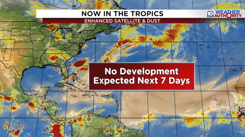
Forecast models are muted through at least the first week of August, which would keep 2026 on pace as the slowest start to a hurricane season since 2009. We’ll have more details of the longer-range picture in future newsletters this week, but in brief, the Atlantic is in rough shape headed into the peak weeks of the hurricane season, which bodes well for noticeably less activity this season.
Copyright 2026 by WPLG Local10.com - All rights reserved.
