
August is typically the month the Atlantic hurricane season comes alive, when bigtime hurricanes are no longer the exception and when we start paying closer attention to each tropical wave plodding westward across the Atlantic from Africa.
Last year, August brought us Category 5 Hurricane Erin. The year prior, Hurricane Debby struck Florida on August 5th, the first of five U.S. hurricane landfalls that season. In 2023, Idalia rapidly intensified to a Category 4 hurricane in the 24 hours leading up to its end-of-August landfall in Florida’s Big Bend.
August can give us a pass – like in 2022 when August ended without a single tropical depression, storm, or hurricane, only the second August in 60 years to do so – but that’s a rare treat when it happens.
That said, if ever you were betting on a sluggish open to the August portion of the hurricane season, it’s this August. As we’ve covered extensively in the newsletter this season, the Atlantic basin – including the Gulf and Caribbean – is squarely on the struggle bus. Waters in the tropical Atlantic are as tepid as they’ve been in four years, wind shear is as high as we’ve ever seen it to start August, and sinking air is weighing heavy on disturbances that might otherwise try to grow.
That knockout one-two combo of high wind shear and sinking air is firmly in place and doesn’t look to be retreating anytime soon. Perhaps the most telling chart is the one below which shows the positioning of rising and sinking air across the globe and what’s forecast into the first few weeks of September.
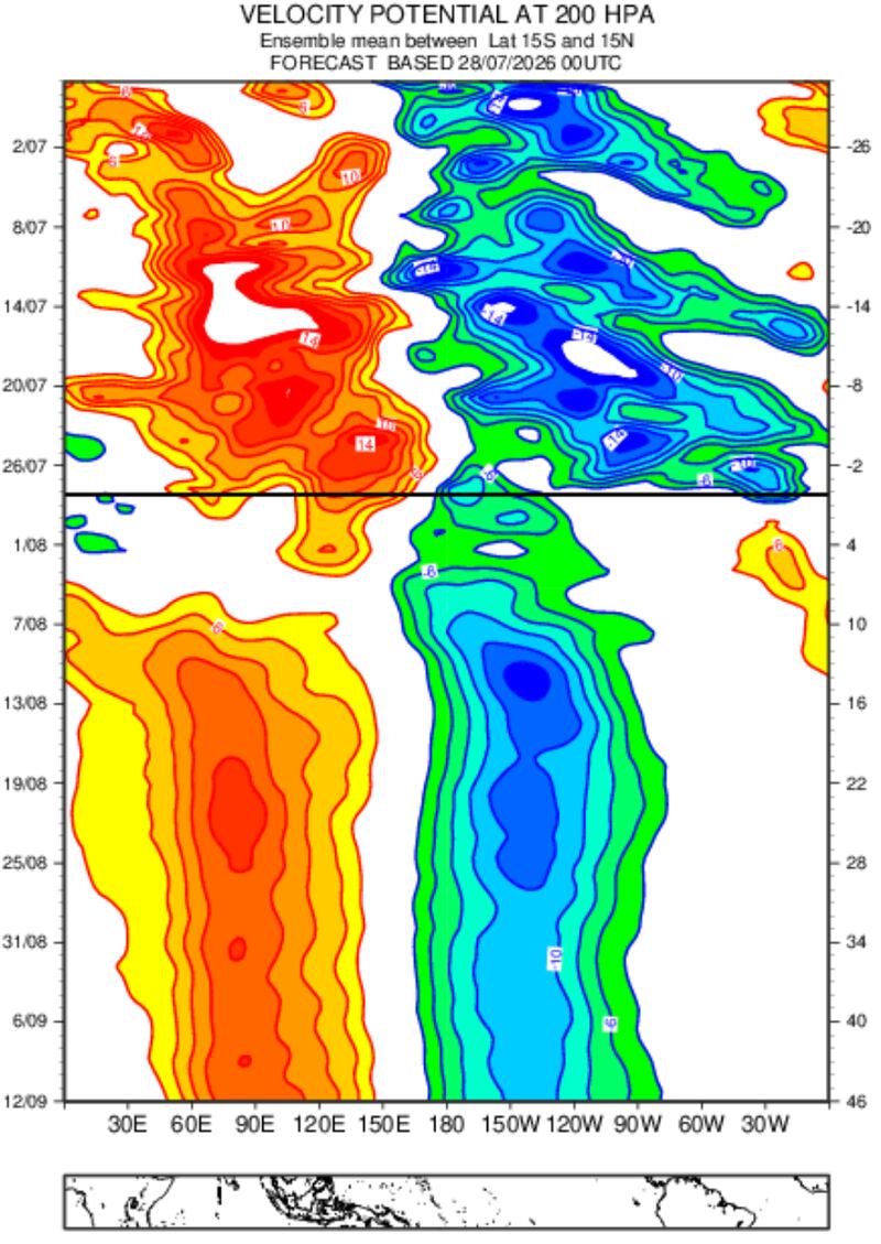
The long band of oranges and reds squared over the Indian Ocean next to the long band of greens and blues stuck over the Pacific is a so-called standing wave configuration that promotes high wind shear and stable air across the Atlantic, both significant deterrents to tropical activity. It’s rare to see such a strong signal in global velocity potential anomalies, but this striking pattern reflects just how much of a toll the historic El Niño is taking on the atmosphere.
I’m not bold enough – even in a year like this one – to suggest we’ll see the Atlantic completely shutdown this August (especially deeper into August), but we should certainly expect it’ll be much quieter than usual. With a configuration like the one shown, we should probably look north of the traditional tropical belt into the subtropics, something we’ve covered in previous newsletters, which could open periodic windows which might favor development.
For now, however, we’re not seeing any such development windows in the near future and forecast models show little to nothing through at least the first week or two of August.
Copyright 2026 by WPLG Local10.com - All rights reserved.
