

The low-pressure system located over the central Atlantic early Wednesday about 600 miles east of Bermuda and being tagged for possible development by the National Hurricane Center remains convectively starved and appears to be in no hurry to organize.
Forecast models remain split on whether the system will eventually make a run at becoming a tropical depression or named storm in the coming days as it loiters over open Atlantic waters into early next week. The next name on the list is Fay.

Our traditional physics-based models remain wholly unimpressed with its prospects while AI models have been more bullish but also jumpier, waffling back and forth on development odds from run-to-run.
Both the Euro AI model ensemble and Google’s DeepMind 1,000-member ensemble system suggest a medium chance it clears the necessary hurdles this weekend into early next week, but the traditional physics-based Euro and American GFS ensembles continue to insist it’s a nothingburger.

While the deep tropical belt of the Atlantic basin between the Caribbean and Africa has been pummeled by hostile wind shear courtesy of the record-setting El Niño, the basin writ large has also been overcome with dry, sinking air, with exceptionally high surface pressures making storm development hard to come by.
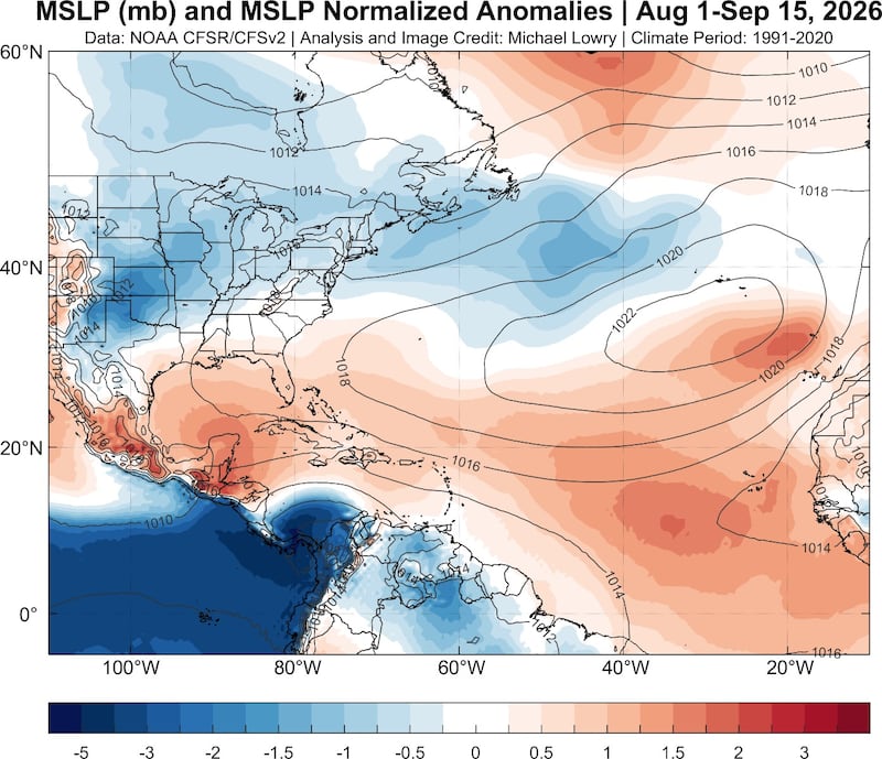
This has been the trend with weak and anemic tropical waves this season and systems like the one over the central Atlantic Wednesday struggling to pull together a coherent area of organized thunderstorms.
One thing that hasn’t been a limiting factor this season are plumes of Saharan dust, which have been running well below average this season, with overall tropical North Atlantic dust cover the fifth lowest of the 25-year satellite record.
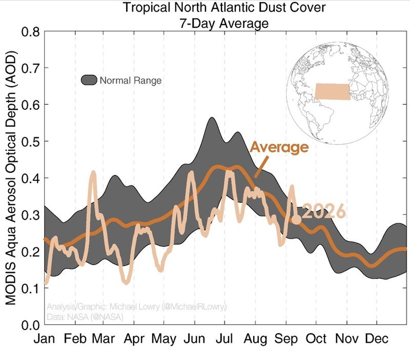
We’ll see if the low-pressure system east of Bermuda can muster up more organized storminess by the weekend as wind shear begins to relax, but for now it’s only something to monitor for interests in Bermuda next week. Regardless of development, it won’t pose a threat to the U.S.
Keeping an eye to the Gulf to end September
There are some early signs in our long-range models that the Central American Gyre or CAG – a broad area of spin and storminess that stretches from the eastern Pacific across Central America and into parts of the western Caribbean and Gulf – could take shape by the end of the month.
This will likely cause a tropical system to form closer to Mexico on the Pacific side but occasionally lobes of spin and storminess can break off and spawn tropical systems over the Gulf and Caribbean. A smattering of scenarios in our long-range ensembles suggests that’s a possibility but it’s too far out (more than 10 days) to put much stock in it.
For now, chances are low but it’s something we’ll check back on in the coming days.
Copyright 2026 by WPLG Local10.com - All rights reserved.
