
Author’s note: The taxpayer-funded tools from NOAA I consulted to provide the forecast information and analyses in today’s newsletter include wind analyses from the University of Wisconsin’s Cooperative Institute for Meteorological Satellite Studies (CIMSS) and the High Resolution Ensemble Forecast (HREF) viewer made available by NOAA’s Storm Prediction Center. CIMSS is one of over a dozen weather and climate facilities slated for elimination in NOAA’s 2026 proposed budget.
Leer en español
A disturbance that emerged off the coastal Carolinas on Sunday is expected to swing across Florida and into the Gulf by mid-week, where models suggest it could slowly develop as it scrapes across the northern Gulf Coast.
For now, models aren’t overly enthusiastic about significant development, but we’ll need to watch it closely since it’ll be near the coast most of the week.
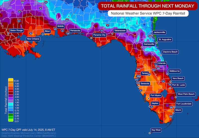
The primary short-term threat will be heavy rainfall across much of the Sunshine State, especially from along the state’s sweeping big bend through its long-tailed peninsula.
Southeast Florida – including the I-95 urban corridor of Miami-Dade, Broward, and Palm Beach Counties – is under a Flood Watch from this afternoon through this evening for the threat of widespread heavy rainfall and the potential of scattered, but mostly localized, flash flooding.
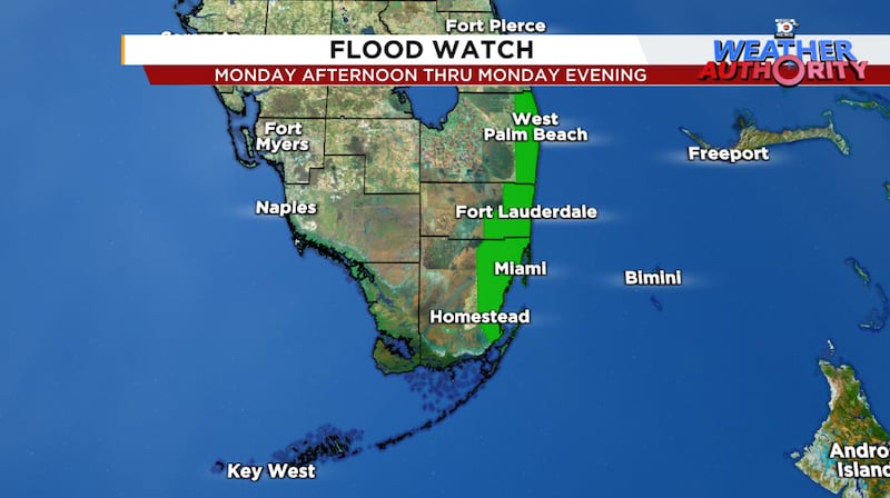
The timing of the heaviest rainfall today will be particularly bad as it will coincide with the evening commute during the 4 PM to 9 PM window. The National Weather Service is calling for widespread 1 to 3 inches across the Flood Watch area later today, with scattered pockets of 3 to 5 inches and up to 7 inches in isolated spots. We’ll need to watch especially for slower moving storms capable of dropping heavy rain in a short period
The National Weather Service keeps most of the Florida peninsula and Florida Keys under a slight risk of excessive rainfall (level 2 of 4) through at least Wednesday morning, indicating an extended flood threat into the middle part of the week.
The first real test for new AI models
As the broad low-pressure area slides westward across Florida and into the northern Gulf on Wednesday, models suggest a window for possible tropical development.
The environment ahead is far from pristine, with modest wind shear in the vicinity at the base of an upper-level high pressure zone, but the stretch of waters from Louisiana to Florida is noticeably warmer than average and supportive of gradual development.

Our reliable forecast models, including both the American GFS and European models, are lukewarm on development. Interestingly, however, the brand-new European AI-based ensemble system – deployed at the start of this hurricane season – is noticeably more bullish than the traditional, physics-based Euro ensembles.

It’ll be a good test case for the next generation AI-system from the gold standard of global forecast models. Both the Euro AI models and its traditional ensembles are somewhat bullish compared to the single forecast (deterministic) versions of the Euro and American GFS, which lends credence to this one outperforming expectations.
Time will tell but given the stance of AI models and its proximity to the coast, we’ll need to keep tabs on it.
Regardless, heavy rain will be a threat into parts of South Louisiana later this week.
CLICK HERE to download the Local 10 Weather Authority’s 2025 hurricane survival guide.
Copyright 2025 by WPLG Local10.com - All rights reserved.
