
Author’s note: The taxpayer-funded tools from NOAA I consulted to provide the forecast information and analyses in today’s newsletter include wind analyses from the University of Wisconsin’s Cooperative Institute for Meteorological Satellite Studies (CIMSS). CIMSS is one of over a dozen weather and climate facilities slated for elimination in NOAA’s 2026 proposed budget.
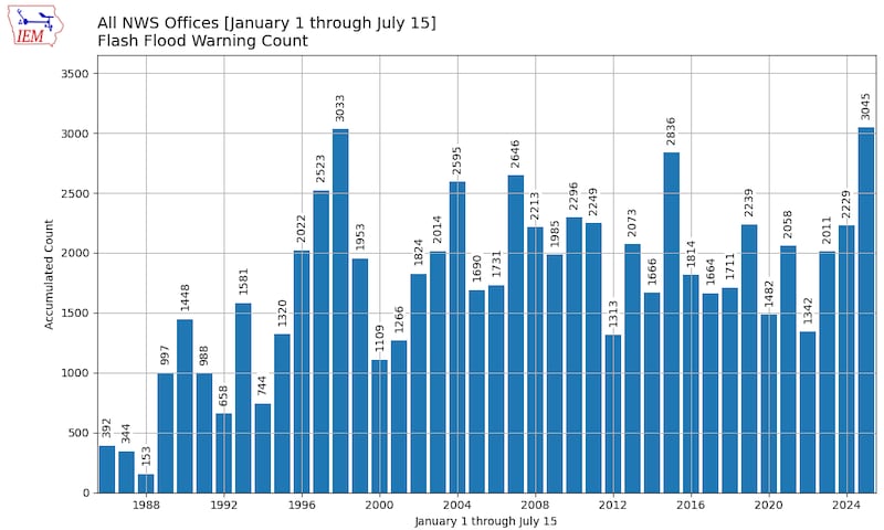
2025 has been the year of the flood. The tragic July 4th flooding in central Texas – the deadliest flash flood in at least 50 years in the U.S. – punctuated what’s been an especially bad year for flooding across the country. So far in 2025, National Weather Service offices have issued more flood warnings than any other year on record dating back to 1986.
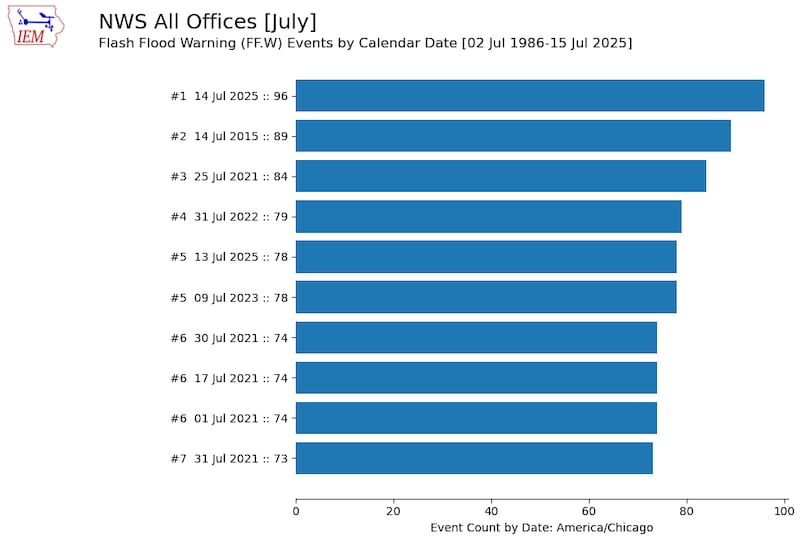
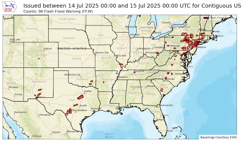
Yesterday alone, 96 flash flood warnings were issued across the U.S. – the most of any July calendar day on record – most notably across parts of New Jersey, New York, and Pennsylvania, where intense rain and widespread flooding led to high water rescues, airport ground stops, and flooded subways. New York City recorded their second wettest hour on record as over 2 inches of rain fell between 7 and 8 PM Monday.
Unfortunately, the trend is expected to continue this week from a tropical disturbance moving across Florida and into the Gulf, bringing a threat of heightened flooding along the northern Gulf Coast, especially into Louisiana by late week and the weekend.
Invest 93L could gradually develop
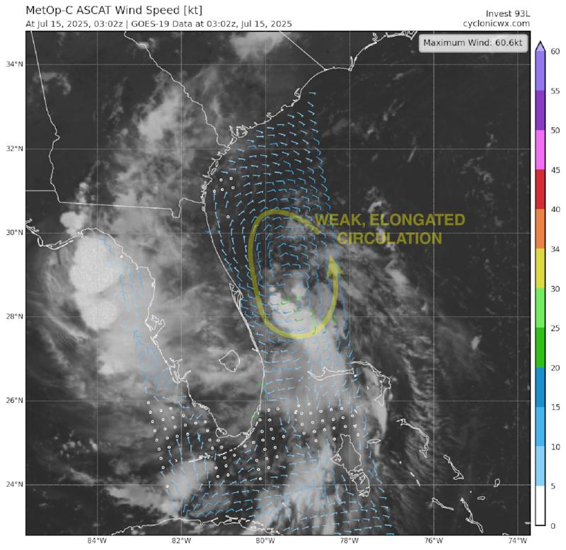
The disturbance we discussed in yesterday morning’s newsletter was designated Invest 93L by the National Hurricane Center yesterday afternoon.
The area of low pressure is swirling only about 50 miles east of Daytona Beach off Florida’s east-central coast this morning. Northerly wind shear raining down atop the system has kept thunderstorms disorganized and displaced to the south and west side of the disturbance.
For now, satellite data show the circulation is weak and stretched out from north to south, so it still needs time to cook in a zone of less hostile upper-level winds.
It may have that opportunity once it crosses Florida and emerges into the northeastern Gulf tomorrow. Models are still tepid overall on development odds (though more intrigued than Monday), which is probably why NHC has capped development odds at 40% for now.
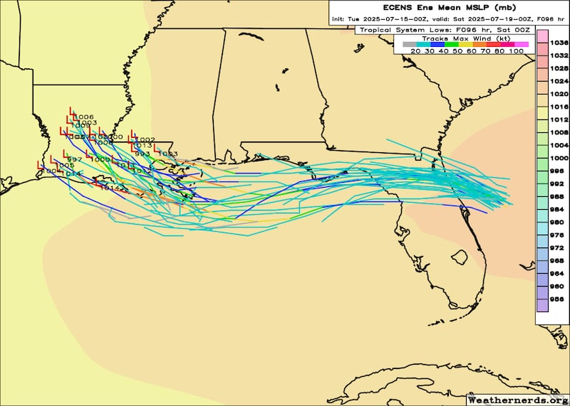
That said, it wouldn’t at all be surprising to see the system gain enough organization tomorrow and Thursday to become a tropical depression or borderline tropical storm (Dexter), especially if it stays far enough south and over the warm Gulf waters where wind shear will be less problematic for development.
Heightened late week flood threat for southern Louisiana
Regardless, our models for now don’t suggest significant development odds with 93L and the primary threat will be heavy rainfall and the potential for flooding from parts of the Florida peninsula today to the northern Gulf Coast states beginning tomorrow into the weekend.

The flood threat is especially concerning across parts of Louisiana for late week and the upcoming weekend. The National Weather Service is already signaling a moderate risk for excessive flooding (level 3 of 4) for southern Louisiana on Friday.
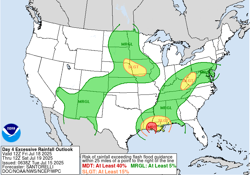
It’s too soon to pinpoint exactly where the greatest risk of flooding will be, but folks in southern Louisiana especially should follow the forecasts closely as models suggest the potential for double digit rainfall totals later this week.
CLICK HERE to download the Local 10 Weather Authority’s 2025 hurricane survival guide.
Copyright 2025 by WPLG Local10.com - All rights reserved.
