
Hurricane hunters — aircraft crews from the U.S. Air Force and NOAA that routinely fly hundreds of missions each season (NOAA banked 63 missions in 2025 while the Air Force flew a total of 77 missions last season), piercing directly into the heart of hurricanes to collect critical data for forecasters — have been a mainstay of the U.S. hurricane warning network for over 70 years.
Over the years, studies have shown data collected by hurricane hunters, which drop thousands of instruments each year into the core of hurricanes and surveil the structure of storms by way of 3-dimensional radar, help to improve track and intensity forecasts by an average of 10 to 20 percent.
For a four- to five-day forecast, that amounts to a reduction in track error of about 25 miles. With coastal evacuations costing about $1 million per mile, this improvement from hurricane hunters alone is estimated to save taxpayers about $25 million for each hurricane impact.
Now, in new research published earlier this month, NOAA scientists for the first time evaluated the forecast improvements from hurricane hunter data after landfall, including for predictions of catastrophic flooding.
Researchers analyzed 10 high-profile hurricanes from 2017 to 2020 — including Hurricanes Harvey (2017) and Florence (2018) which brought catastrophic and deadly inland flooding to parts of Texas and the Carolinas respectively — and found significant improvements in post-landfall rainfall forecasts from data collected by hurricane hunters before landfall when each storm was still over open water.
The research team credited improvements in the inland track forecast from data collected by hurricane hunters in ultimately improving the rainfall forecasts for the storms included.
This is consistent with preliminary results from other studies that have examined the improvements to rainfall forecasts from aircraft reconnaissance during Atmospheric River events over the U.S. West Coast and Canada.
Bipartisan support for expanding the hurricane hunter fleet
The new research from NOAA shows just how valuable data from hurricane hunters are for forecasting potentially deadly hazards before and after landfall, and Congress is taking note.
In June, a bipartisan group of senators introduced a bill that would authorize $2.5 billion to expand the aging fleet of NOAA hurricane hunter airplanes — 50 years old this season — from 3 now to a minimum of 6 and up to a maximum of 9 crewed aircraft, plus $45 million each year for routine operations and maintenance of the upgraded fleet.
Republican Senator Ted Cruz and Democratic Senator Maria Cantwell who introduced the bill both cited the need for critical data to improve forecasts and support earlier warnings in statements issued last month.
The push to expand hurricane hunters comes a year after the Trump administration proposed eliminating the scientific office of NOAA that supports the life-saving work of its hurricane hunter missions, including crucial data collection and ensuring hurricane hunter data is included in NOAA’s state-of-the-art hurricane models.
At the time the administration proposed a significant reduction in flight hours for hurricane hunter aircraft for this hurricane season — a 52% and 33% reduction from flight hours in 2023 and 2024, respectively – largely due to the elimination of its research laboratories and related goals.
Despite the request last summer from the administration to severely cut or wholly eliminate budgets for hurricane forecasting, bipartisan Congressional committees have continued to both reject and rectify NOAA’s budget during its appropriations process, providing full funding (and then some) for NOAA’s weather enterprise, including its research laboratories and cooperative institutes critical to hurricane forecasting.
No Atlantic candidates on the horizon
As we covered in Wednesday’s newsletter, the Atlantic will be dealing with historically high wind shear for at least the next week or two, which should keep things quiet to open August.
Some of the AI models — including the European AI ensemble and Google’s DeepMind ensemble — are picking up on a disturbance over the far eastern Atlantic (between Africa and the Caribbean) as we approach the middle part of the month.
For now, the signal is very weak (less than 10%), but a low signal this far out (10+ days) is worth checking back on in the weeks ahead.
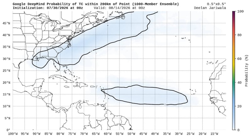
For now, it’s nothing we need to worry about.
Copyright 2026 by WPLG Local10.com - All rights reserved.
