

Luke Dorris joined the Local 10 Weather Authority just in time for Hurricane Irma in 2017.

A native of the St. Louis area, Luke originally began college studying his other passion -- cars.

Luke enrolled in college to study automotive engineering and landed a part-time job in a beer distribution warehouse, where he operated a forklift to load beer trucks after classes. It was here that his whole life changed.

He was working an exceptionally hot summer evening in the warehouse when a storm blew in and began raining, then hailing so hard that drivers from the nearby state highway pulled into the parking lot to ride out the storm. The awning on the front of the building blew off and landed on one of the vehicles.

The aluminum-sided warehouse made an awful creak and then partially blew down. Luke thought he was getting hit by a tornado, but he later found out it was a "microburst," or severe straight-line winds in excess of 90 mph.

Luke, fascinated as much as he was scared, transferred to the University of Oklahoma, where he received a Bachelor of Science in meteorology and chased a few storms when he could.

He also was fortunate enough to intern with Gary England, Michael Armstrong and the weather team at KWTV in Oklahoma City. (If you have seen the opening scene of the movie "Twister," then watch for Gary on the TV in the old farmhouse. He's a great guy, Luke says).


Luke moved to Lincoln, Nebraska, where he eventually became the chief meteorologist at KLKN. During his time there, he covered many tornadoes, severe thunderstorms and snow storms. He also achieved the certified broadcast meteorologist designation from the American Meteorological Society, which is the highest certification available to broadcast meteorologists.
LATEST CONTRIBUTIONS

Florida temperatures to lower to 40s, 50s, 60s on Tuesday
After a few gloomy days with gusts of wind and rain, there will be a reprieve on Monday before temperatures lower to the 60s in South Florida, 50s in central Florida, and 40s in northern Florida.

Art Basel Miami Beach crowd to cause traffic delays in South Beach, Miami
Some of the most important players in the world’s growing modern and contemporary art market are in Miami-Dade County this week, and that means more traffic and a need for more security.

Frente frío con temperaturas de a 50 y 60 grados vienen al sur de Florida
Después de un lunes más cálido de lo normal para esta época del año en el sur de Florida, un frente frío bajará las temperaturas el martes y el miércoles.
Weather alert in South Florida: Cold front to lower temps to upper 50s, 60s
After a Monday that is warmer than normal for this time of the year in South Florida, a cold front will drop temperatures on Tuesday and Wednesday.

Emily no representa una amenaza, pero Franklin podría ocasionar inundación repentina en La Española.
Hurricane season starts to peak: Tropical storms Emily and Franklin form in Atlantic
The National Weather Service announced on Sunday that two new tropical storms had formed in the Atlantic.

Miami-Dade, Broward counties issued Excessive Heat Warning
An Excessive Heat Warning is now in effect for Miami-Dade and Broward counties, for the second time ever.

Miami-Dade, Broward, Palm Beach under severe thunderstorm watch
The National Weather Service issued a Severe Thunderstorm Watch on Wednesday afternoon covering an eastern Florida area that includes Miami-Dade, Broward and Palm Beach counties.
Flood Watch in effect through Wednesday night for metro Miami-Dade, Broward
A Flood Watch was issued Tuesday for Miami-Dade and Broward counties and it’s expected to be in effect through 8 p.m. Wednesday.

Tropics continue to hit snooze this week
The Atlantic remains in a state of slumber at the moment, with no tropical depressions expected to develop through the end of the week.

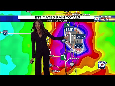
Tropical Storm Alex moves away, South Florida drying out following day of rain and flooding
Miami-Dade and Broward residents are cleaning up after over a foot of rain fell in parts of South Florida.

NOAA expects 6 to 10 hurricanes during above average season
Meteorologists expect the 2022 Atlantic hurricane season, from June 1 to Nov. 30, to be the seventh consecutive season to be above average.

NOAA espera 6-10 huracanes durante temporada más activa de lo normal
Los meteorólogos esperan que la temporada de huracanes en el Atlántico de 2022, del 1 de junio al 30 de noviembre, sea la séptima temporada consecutiva mas activa de lo normal.

Strong weekend storms possible across South Florida
Showers and severe thunderstorms possible both Saturday and Sunday

Here is why Floridians shouldn’t put away their winter wardrobe yet
The Arctic air’s zombielike iguanas are behind for eastern South Florida residents, but it is still too soon to put away the winter wardrobe.